
-
 3297 Hits
-
 82.48% Score
-
 15 Votes
|
|
Mountain/Rock |
|---|---|
|
|
47.82494°N / 15.74021°E |
|
|
Hiking, Skiing |
|
|
Spring, Summer, Fall, Winter |
|
|
4495 ft / 1370 m |
|
|
Topographic isolation: 4 km
Nearest higher peak: Wirtshauskogel (1486 m) in Schneeberg
Prominence: 632 m
![Freudentaler Mauern]()
Freudentaler Mauern![Falkenstein in clouds]()
Falkenstein in cloudsIf somebody wants to find a good hiking destination near Vienna, and he/she wants something else than Schneeberg or Hohe Wand, then Handlesberg would serve him/her well. It is only 90 km far from Vienna. But it seems that most people still want to go to Schneeberg and to Hohe Wand. Handlesberg is quite abandoned in the "shadow" of Schneeberg. It is adjacent to Schneeberg: they are separated from each other with the valley of Voisbach.
Handlesberg belongs to the mountain range of Gutenstein Alps, and it is the second highest peak of the range with its 1370 m altitude. The highest peak of the range is not much higher: it is the 1399 m high Reisalpe. The prominence of Handlesberg is 606 meter, and with this value it has rank 14 on the prominence list of Lower Austria.
The name of the mountain comes from the German word "Hahn" meaning Cock. Handlesberg is made of various kinds of limestone, and dolomite in the depth, with all typical character of the limestone mountain range of the alps: sharp rock ridges and rock walls, rich vegetation, karst activities like caves and karst spring.
Our mountain has three summits worth mention:
![Red limestone painted by bauxite]()
Red limestone painted by bauxite. Or iron-oxid?![One of the caves of Falkenstein]()
One of the caves of FalkensteinRecommended mountaineering activities are ski-touring and hiking.
Ski-tracks:
• From Handlesberg summit (1370 m) to Reitbauer (670 m)
• From Handlesberg summit (1370 m) to Steinhauer (990 m)
Marked hikig trails:
• From the valley of Voisbach (Wagenhof) to Handlesberg: , 2 x 6 km, 710 m elevation gain
• From the valley of Paxbach (Gschaiderwirt) to Handlesberg: , 2 x 6.5 km, 727 m elevation gain
• From the valley of Schawarza (Schwarzau im Gebirge) to Handlesberg: , 2 x 4.5 km, 767 m elevation gain
• From the valley of Schawarza (Bichl) via Kirchensteig to Falkenstein: , 2 x 2.5 km, 405 m elevation gain
Austrian Long Distance Route 06:
Actually Route 06 is a series of pilgrimage routes, all directing to Mariazell. Its eastern branch is called Burgenländische Mariazellerweg. It is a 145 km long route between Eisenstadt and Mariazell. It crosses the southern flanks of Handlesberg. The highest point of this route in Handlesberg is 795 m, in a saddle between Baumeckkogel and Mitterriegel.
![Summit cross of Handlesberg]()
Summit cross of HandlesbergA beautiful cross is erected on the rocky summit. From here you can have excellent view on the neighbouring peaks of the Alps, especially in southern and western direction. The most exposed neighbouring peaks are the following:
• S: Scheibwaldhöhe (1943 m) in Rax
• SW: Amaissbichl (1828 m) in Schneealpe
• W: Ötscher (1893 m)
![Heath Fritillary]()
Heath FritillaryThe western part of the mountain around Falkenstein belongs to the protected area of Naturpark Falkenstein-Schwarzau im Gebirge. But it doesn’t mean that it cannot be accessed on the marked trails.![Grubenfranzl Alm]()
No tourist huts here. This is the abandoned Grubenfranzl AlmThere is no tourist hut on Handlesberg. It is not really a problem, because the whole mountain can be walked through in a day. The nearest camping is 20 km far from our area:
Camping Kohlhofmühl
2763 Neusiedl bei Pernitz, Hauptstraße 2
Telefon: +43/(0)2632/74035
Naturpark Falkenstein: www.naturparke.at/en/Nature_Parks/Niederoesterreich/Falkenstein-Schwarzau_im_Gebirge
Nearest higher peak: Wirtshauskogel (1486 m) in Schneeberg
Prominence: 632 m
Overview
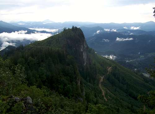
Freudentaler Mauern
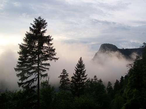
Falkenstein in clouds
Handlesberg belongs to the mountain range of Gutenstein Alps, and it is the second highest peak of the range with its 1370 m altitude. The highest peak of the range is not much higher: it is the 1399 m high Reisalpe. The prominence of Handlesberg is 606 meter, and with this value it has rank 14 on the prominence list of Lower Austria.
The name of the mountain comes from the German word "Hahn" meaning Cock. Handlesberg is made of various kinds of limestone, and dolomite in the depth, with all typical character of the limestone mountain range of the alps: sharp rock ridges and rock walls, rich vegetation, karst activities like caves and karst spring.
Our mountain has three summits worth mention:
The highest peak of Handlesberg (1370 m)
With a beautiful summit cross on its peak-rock and with good panoramic view on the nearby ranges of the Alps.
Freudentaler Mauer
It is a rocky ridge with an almost vertical north face. It is only 500 meter west to the highest peak. And only a little bit lower: approximately 1330 m high.
Falkenstein (1013 m)
It is 3 km far from the highest peak, on its western side. Though it is not too high, it looks to be really high if you look at it from the valley of Schwarzau, as it is towering just above the river bed. Falkenstein a nature-protected area, with intensive karst activities: 3 caves (Bärenloch, die Herrengrotte and Frauengrotte) and the karst spring of Klafterbach.
Activities
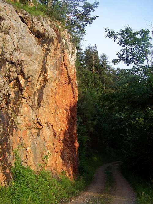
Red limestone painted by bauxite. Or iron-oxid?
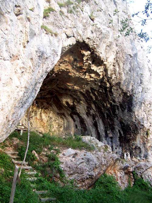
One of the caves of Falkenstein
Ski-tracks:
• From Handlesberg summit (1370 m) to Reitbauer (670 m)
• From Handlesberg summit (1370 m) to Steinhauer (990 m)
Marked hikig trails:
• From the valley of Voisbach (Wagenhof) to Handlesberg: , 2 x 6 km, 710 m elevation gain
• From the valley of Paxbach (Gschaiderwirt) to Handlesberg: , 2 x 6.5 km, 727 m elevation gain
• From the valley of Schawarza (Schwarzau im Gebirge) to Handlesberg: , 2 x 4.5 km, 767 m elevation gain
• From the valley of Schawarza (Bichl) via Kirchensteig to Falkenstein: , 2 x 2.5 km, 405 m elevation gain
Austrian Long Distance Route 06:
Actually Route 06 is a series of pilgrimage routes, all directing to Mariazell. Its eastern branch is called Burgenländische Mariazellerweg. It is a 145 km long route between Eisenstadt and Mariazell. It crosses the southern flanks of Handlesberg. The highest point of this route in Handlesberg is 795 m, in a saddle between Baumeckkogel and Mitterriegel.
On the Summit
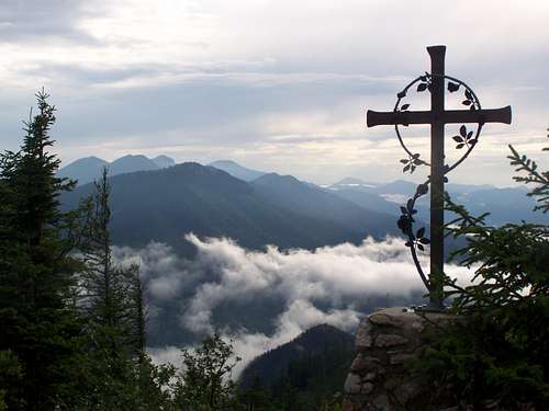
Summit cross of Handlesberg
• S: Scheibwaldhöhe (1943 m) in Rax
• SW: Amaissbichl (1828 m) in Schneealpe
• W: Ötscher (1893 m)
Flora and Fauna
Instead of words: Alpine cyclamen Alpine cyclamen |  Big-flowered foxglove Big-flowered foxglove |  Heath spotted orchid Heath spotted orchid |  Martagon Martagon |  Six-spot burnet Six-spot burnet |  Peach-leaved bellflower Peach-leaved bellflower |
When to Climb
In any season.Red Tape
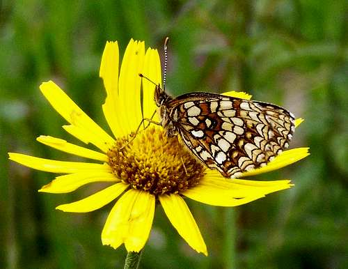
Heath Fritillary
Camping and Tourist Huts
No tourist huts here. This is the abandoned Grubenfranzl Alm
Camping Kohlhofmühl
2763 Neusiedl bei Pernitz, Hauptstraße 2
Telefon: +43/(0)2632/74035
External Links
Online touris map of Austria: www.austrianmap.atNaturpark Falkenstein: www.naturparke.at/en/Nature_Parks/Niederoesterreich/Falkenstein-Schwarzau_im_Gebirge