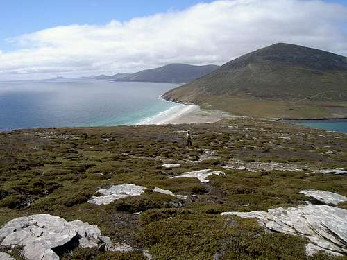
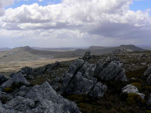
Typical open Falklands hiking terrain on Pebble Island
The last two weeks of November saw my wife and me once again in the wild and wonderful Falkland Islands. A previous visit in 2005 was mostly to see the incomparable wildlife in the Islands whilst trying not to eat too much without offending the locals’ incredible hospitality. We had plenty of opportunity to recognise, however, that with their open, trackless terrain the Islands would make a superb hiking destination and we accordingly made this the principle focus of our latest trip down there.
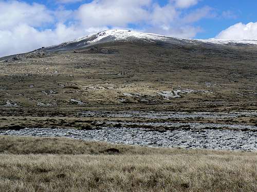
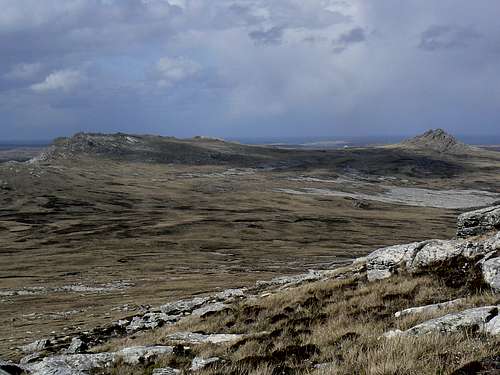
Falkland Island mountains are neither high nor rugged. They’re more like high heathland topped by ridge-like tors, not unlike Dartmoor in the UK or certain areas of Tasmania. What challenge is lost to simple lack of height, however, is more than made up for by the conditions. There are no trails. Risk of hypothermia is ever present. The constant frigid wind, uninterrupted on its passage from the Antarctic, can literally blow you off your feet. “Summer” weather includes sunshine one minute and a snowstorm/white-out the next. There are no trees and the mountainsides are mostly bare and open to the wind with limited possibilities for shelter in an emergency. Not, in the sparsely populated Falklands, that getting hold of anyone in an emergency would be likely anyway. On all hikes I carried clothing appropriate to climbing something more akin to Mt Rainier and often used all of it.
Later on I will post individual mountain pages with details on how to get to and climb various mountains in the Islands. For now I’ve selected three examples from our hikes that, I think, will provide a good cross section for those who, one day, may want to venture down to this wild and beautiful place.
November 15. Mount Usborne.
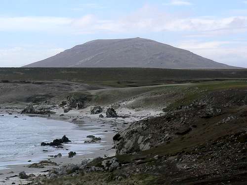
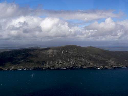
Mt Usborne from the west
At 706 metres Mt Usborne is the highest point in the Islands. It lies on the west/east arc of hills that run across the northern half of East Falkland Island roughly from San Carlos Water (the site of the British landing in the war of 1982) to Stanley, the Islands capital and only town of any size.
After spending the night at Kingsford Farm at the settlement at San Carlos our host, Terry, took us in his Land Rover back along the Mt Pleasant road to the point where he thought he knew of a track up Usborne. It was difficult to say if he was right or not since we were into thick fog pretty well as soon as we’d left the settlement.
Climbing Usborne in poor vis
Approaching summit plateau in better vis
Summit plateau in a very poor vis
Mt Usborne summit
In any event we turned left off the road at the chosen spot and headed up into the murk. We then got to experience the best of off-road driving that the Islands have to offer. On Vancouver Island, we think we’re pretty hot stuff when it comes to getting up all those decommissioned logging roads. Let me tell you that even the worst of such roads are a freeway compared to driving the “wet camp” (boggy moorland) of the Falklands. I would have been walking long before, in the middle of a bog somewhere on the saddle between Usborne and Canterra Mountain to the west, Terry declared the track at an end (what track?!) and said we’d be walking from here.
Usborne summit view W
Descending Usborne
Once clear of the bog it was straightforward hiking east up dry balsam bog and “diddle-dee“ covered slopes to the seasonal snow line. Mt Usborne has wonderful examples of what Islanders call “stone runs” on almost all of its slopes, although covered with snow, the broken, treacherous ground made for slow going. Once above this, however, the summit plateau soon came into view through the mist and snow and we followed the GPS across it to the high point. Apparently there’s a summit register but it was buried in the snow. The 360 degree summit views extended for all of 10 metres from the cairn.
Although not as strong as usual, the wind and cold temperatures combined to make our visit a short one and after 5 minutes on top we headed down.
As I have mentioned, conditions in the Falklands are changeable in the extreme and we were almost at the Land Rover when the inevitable happened. The wind picked up, the fog blew away and there above us was a clear hillside framed by blue skies. This was a chance not to be missed and with an abrupt about-face up we went again, this time much faster in the perfect visibility.
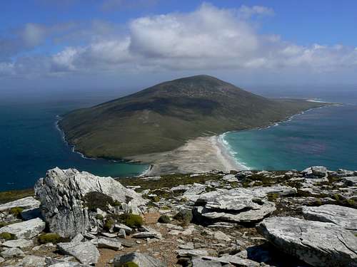
Canterra Mountain & West Falkland
So we finally got to see the view from the highest point in the Falklands and stunning it was too - at least 50 km across Falkland Sound to snow-capped Mt Maria, the second highest point on West Falkland and third in the Falklands.
Outside of cruise ship visitors, not that many folk visit the Falklands and not too many of those venture up Mt Usborne. We felt quite special, therefore, when a Falkland Islands Government Air Service (FIGAS) flight off in the distance made an abrupt left turn and made a pass over the summit to check out the rare visitors.
Back at the settlement that evening and over another huge and delicious Falklands dinner, Terry revealed that he hadn’t been up Usborne for 30 years. He guessed that doing it twice in a day made up for that somewhat!
Mt Usborne from the old gaucho corral
November 22. Saunders Island Traverse.
The Saunders Traverse from Mt Harston
Saunders Island is one of the largest islands to the north of West Falkland and we had been there to see the penguin colonies during our 2005 trip. Whilst there Gwen and I hiked over Mt Harston, the high point west of the cabin where we were staying. From Mt Harston it was readily apparent that an east/west traverse of the high ground down the length of the north part of the island should be feasible. A few minutes on the internet after we got home gave the identity of two of the eastern summits in our photographs: Rookery Mountain and Mt Richards. Two further significant high points separating Mt Richards from the “Neck”, the sand isthmus at the base of Mt Harston, were unnamed and probably regarded as satellites of Richards. The hike certainly went right to the top of the list for our second trip and to this end we arranged to stay at a new cabin at the eastern end of the chain of peaks that we’d seen from Mt Harston.
The weather was very questionable on November 21st so we contented ourselves with short walks around the cabin. One of the best rockhopper penguin colonies in the Islands was just 10 minutes away at the foot of Rookery Mountain. Even more impressive, however, were the black-browed albatross colonies that populate every cliff down the length of the north coast of the island between Rookery and Mt Harston. You could literally sit on the cliff edge in the flight path as the birds came and went just inches away.
November 22nd dawned windy but reasonably clear so I was up early and away from the cabin before 7. A long hike was in prospect so Gwen elected for another day visiting with the wildlife.
Rookery Mountain north aspect from the air
From the cabin I walked west until I could smell the rockhoppers and then struck southwest up to a low point in the ridgeline above where I turned right. Once on the ridge superb views south to West Falkland Island opened up and were with me for the rest of the day as long as I kept to the high ground. To the north was nothing but the wild South Atlantic.
Rookery Mountain start
Rookery Mtn summit view E
Rookery Mtn summit view W
Rookery Mtn survey monument
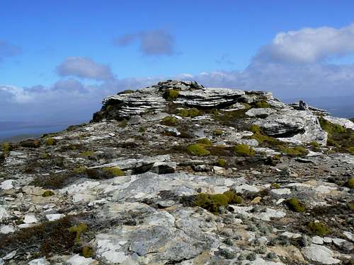
The ridge had a few boggy spots but nothing to impede progress at almost trail speed as I headed up to the highest point I could find on Rookery Mountain, the first summit of the day. The top was the usual rock fin but it had a cairn on top and, to my surprise, a survey monument – and an unusual one. The brass plate was placed on behalf of the Hydrographic Dept, MoD Navy, Taunton by the crew of HMS Endurance in 1995. Endurance has a long history in the area having been the only significant British military presence in the South Atlantic in the years before the 1982 war with Argentina.
Rookery Mountain summit
Even before I had reached the top of Rookery the weather had changed for the worse. The big seas to the north disappeared as the cloud came down and, at the same time, the wind rose to gale force. I took shelter in the lee of the summit, emerging on all fours a couple of time to take photos of the survey monument, and tried to be patient. Sure enough, after 20 minutes or so the squall passed and I could see Mt Richards across a saddle to the southwest.
The onward route west from Rookery Mountain and an example of typical Falklands wind conditions
Bypassing a high point on the ridge I dropped 250 metres south then southwest down rather tedious balsam bog slopes to the grassy saddle and then regained the same elevation west to the top of Mt Richards and another battle with the wind. Just the usual series of rocky fins this time, no cairn (so I built one) and certainly no survey monument. The two unnamed high points ahead to the west looked every bit as high as the point I was on but at least visibility was now good and I could see where I was going.
South from Rookery
Mt Richards summit
Mt Richards summit view S
Mt Richards W satellite
Heading now northwest from Richards I dropped another 250 metres to another, much wider, saddle where I encountered a big cairn and a fence. I could see that the latter dropped right down the north side to the ocean below. My route, however, lay further west so up I went once more.
I knew that that I was approaching the last two high points before the final descent down to sea level to “The Neck” at the foot of Mt Harston. So, instead of going right over the tops, I chose to start a descending traverse from about 50 metres below the first summit on a line that I reckoned would take me down to the sand and save a bit of unnecessary climbing. Big mistake! The line took me right into a steep stone run. Teetering across razor sharp unstable rock in 80 kph winds brought several unhappy thoughts to mind. Chief amongst them was that within the whole compass of all that I could see there was not one other human being. In fact, apart from my wife at the cabin and the people in the settlement, 10 miles away, considerably more than what I could see contained no human being. This was not a very sensible thing to be doing alone. An accident here didn’t bear thinking about. So with sea cliffs below I did the only practical thing and headed carefully up and back into the wind and the safety of the ridge.
Richards W stone run
Stone run from ridge
Mt Richards W summit
Mt Richards W summit view S
Now on the last high point and with the bulk of Harston over 6 km away, there was no shelter from the west wind which, once more, was blowing at gale force. Head down I trudged directly into the wind along the ridge and then down until, about 200 metres above the sand, I decided that honour had been satisfied and that I’d save a bit of energy for the return trip.
Once in the lee of a convenient outcrop I settled in for lunch and to take in everything around me. To the south, islands and islets without number in a bluer than blue ocean. To the north, the storm-wracked black South Atlantic. Brown, barren hillsides devastated by the winds of ages in all directions. Below, a white sand isthmus dotted with thousands of penguins. Fan-bloody-tastic. I got up, wedged my legs into a crevice in order to be able to stand upright and whooped and hollered my approval into the gale.
Mt Harston and The Neck
Heading back finally, with the wind now at my back, I stuck to the ridges until I reached the wide saddle below Richards where I headed north and down to the ocean. In the shelter of the ridge above everything was green. Pale Maiden (the Falklands national flower) and pink and white so-called Scurvy Flower were everywhere. I followed a flat bench above the ocean to its end at the foot of Rookery Mountain where further progress along the sea shore was barred by cliffs. Then up the north slopes of Rookery to a point where I could turn east above the cliffs and finally down to the rockhoppers and home.
Returning to Richards
Return route below Richards
Rookery Mountain sea cliffs
What a day. My GPS showed 25 km covered with accumulated elevation gain of over 1,600 metres. And this was without going back over Richards and missing some of Rookery. So much for the small mountains of the Falklands.
November 27. Battlefields Hike.
Argentina has long claimed sovereignty over the “Malvinas”. Frustrated in efforts to negotiate a peaceful transfer of power - one which would require the unlikely agreement of the Islanders - and, some would argue, driven by the need to divert its citizens’ attention from a brutally repressive military dictatorship and an economy on the verge of collapse, Argentina summarily invaded the Islands on April 02, 1982. The ruling junta was probably sure that Great Britain would, after suitable posturing to the contrary, eventually walk away from a colonial anachronism 8000 miles away in the middle of nowhere. Unfortunately for many young men and women on both sides, this didn’t happen. The British equipped and dispatched a military task force in just a few days. The force eventually made a landing at San Carlos, fought its way overland via Goose Green and, by late May, was facing a largely conscript Argentine army in the low mountains to the west of Stanley. A series of short and violent engagements, fought mostly at night, culminated in the surrender of the Argentine forces on June 14.
The Battlefields on the approach to Stanley
By the end of our stay in the Islands, I had a pretty good feeling for the terrain and attendant conditions in what passed for summer down there. I wondered, however, what it must have been like to fight a pitched battle over such ground in the middle of the antipodean winter. The only way to find out, of course, was to visit the ground myself. Our landlady, Arlette, in Stanley thought that this was a fine idea and very kindly dropped me off on the Port San Carlos road where it crosses the lower slopes of Mt Kent.
Mt Kent from the S ridge
Mt Challenger
Mt Challenger summit
Two Sisters
At 460 metres, Mt Kent is the highest ground on the western approaches to Stanley and was, therefore, the British army’s primary initial objective as they sought to take the capital.
Starting my hike from the road, I headed west at first in order to get a good look at Kent. Nowadays there is a permanent military installation on the summit so I was careful to keep to the south side of the ridges that swing round to the top from that direction and took my photos from there. Thereafter I headed down into the valley between the ridge and the summit and started walking the 25 km back to town.
Keeping above the unfriendly stone-runs below, I took a lower parallel course back east towards the Port San Carlos Road. Crossing the road once more I continued east along the sharp ridge of Mt Challenger and on towards Mt Harriet with the Two Sisters to the north. Before I could reach Harriet, however, I was thwarted by a minefield across my intended line of travel. Unsure of how far this extended north, I exercised prudence and dropped south down to the Mt Pleasant road and around that end of the marked area before resuming my easterly course towards Mt Harriet.
Mt Harriet & minefield
Approaching Mt Harriet
Mt Harriet summit
Mt Harriet bunker
The battle for Mt Harriet and Goat Ridge to its east began on the night of May 30, 1982 but didn’t reach its conclusion until June 11 and, even then, only after several heavy naval bombardments as well as “softening up” ground attacks. Accounts of the battle written by both sides belie the commonly held opinion that the Argentine conscripts were no match for the professional British forces opposing them. For nearly 2 weeks they held their positions on Mt Harriet and fought bravely. In the end they were undone because they expected the British assault to come from the west. In fact the British walked through the minefield I encountered, around under the height of land and made their eventually successful attack from the east.
My course took me through what would have been the main Argentine line of defense. The battlefields have supposedly been thoroughly picked over in the intervening 28 years but I found detritus everywhere. Gun emplacements - all with the main fortifications pointing west - gun mounts, batteries, entrenching tools etc etc. What was surprising was the lack of obvious shell damage. The bombardment of Mt Harriet was amongst the heaviest of the war and yet, with the exception of the various military bits and pieces, the countryside appeared unscarred and pristine.
From the gun emplacements I could see Stanley harbour to the west, still over 10 km away. How inviting it must have looked to the Argentine forces as they waited for weeks, enduring the privation and miserable winter and anticipating the inevitable appearance of the British.
With Two Sisters now on my left I headed down off Mt Harriet with Goat Ridge on my right and then up to the saddle between Mts Tumbledown and William.
The Battle of Mts Tumbledown and William
The British attacked the long ridge of Mt Tumbledown on the night of June 13th in two phases. A diversionary attack from the south at 8.30 pm ended up securing the high ground on Mt William whilst the main advance started from the west near Goat Ridge at 9. The subsequent battle was amongst the fiercest of the war. After taking the west end of the ridge against minimal opposition, Scots Guards encountered stubborn resistance and it was only with the help of a naval bombardment and after hand to hand fighting that the Argentines were finally overwhelmed at about 3 am on the 14th. At about the same time that Mt Tumbledown was taken, the Parachute Regiment captured Wireless Ridge to the northeast.
Mt William
Approaching Mt William
Mt William summit
This was the last significant fighting of the war. Opposition melted away and the defeated Argentine troops streamed back towards Stanley and their surrender that evening. I followed in their path now on the long trudge down from Mt William towards Moody Brook and the town beyond thinking all the while of those brave men on both sides who endured simply because it was their duty. Three weeks short of the antipodean summer solstice, I had been buffeted all day by strong winds, sleet and rain. I had staggered through stone runs and squelched through bog after bog. What must it have been like to cover this ground in the middle of winter? And to do so under the constant threat of enemy fire? Even our most fevered imaginings can probably only touch the surface of what it must have been like and my trip was at best a parody compared to the suffering that these men endured. I hope, however, that in some small way it pays tribute to those who so richly deserve it.
The last act of the conflict
Postscript
On our way down to the Islands we spent some time in Argentina. Buenos Aires was seething with demonstrations by Malvinas veterans who, 28 years on, have received neither sufficient recognition from their government nor pensions adequate to the service they gave and the suffering they endured. It seems that there are still plenty of reasons left to cry for Argentina.
Yes there are still many minefields - in fact there's one mentioned in the last of the 3 essays. Walking is not a risk because everything is so well fenced and marked. Just in case anyone's still stupid enough to enter a field, the government has made it an offence to do so.
There have been negotiations going on for a number of years with Argentina to settle the conditions under which the mines will be finally cleared and who will pay. It appears that agreement had been reached. A crew from Zimbabwe was on the ground and beginning the task in the last few days of our visit.
One often reads about the likes of the Andes or the Himalaya... But this was a truly great read about a place way off the beaten track, and to be honest, a much nicer read anyway than the 21st TR about Cho Oyu or the 37th about Aconcagua, just because it catches the spirit of exploration: to go where not many have gone before. Now I would just love to see something about Olavtoppen on Bouvet Island, Swart Peak on Marion or Le Dome on Kerguelen... If you ask me, 11/10 for this page.
I never thought the Falklands looked *that* similar to Northern Scotland though...
Many thanks for reading my piece and the kind words.
To me the Falklands resemble the Outer Hebrides more than N Scotland. And the tor-like summits are very reminiscent of Dartmoor. But, really, the country has its own VERY unique character.
Great page Martin,
you must have had some spooky experiences on some of the tops, thinking about the fierce battles that were so recently fought there.
cheers Johnnie
So many wasted and ruined lives!
But a prime example of sheer grit overcoming injury is Simon Weston who was seriously burned on a troopship. I stood next to him in a Cardiff pub after an England/Wales rugby match (the last one at the old Arms Park I think).
He is an inspiration to all those wounded soldiers who have to get on with their lives in spite of serious physical & mental damage.
But seriously - you're absolutely right. The waste of, above all, human life beggars belief. And that applies to both sides. The only characters who are guaranteed to survive war are those who cause it in the first place.
totally agree Martin, I've always blamed the Iron Lady, but like others that start wars instead of negotiating settlements, no doubt she doesn't lose any sleep over the victims.
Hi Martin, you wrote an excellent page. I'm Argentine and I think you described very well the reasons of the begginig of the war, the course of the battle and the final combat and surrender. But I'm not agree with the postscript; i guess you didn't see the truth of the situation; Buenos Aires is not seething with demonstrations by Malvinas veterans. Perhaps you have seen one demostration (I don't know in what occasion, perhaps for the veteran's day or the sovereignty day); but all argentinians know that Buenos Aires is not seething with demonstrations by Malvinas veterans.
Congratulations for the page again. Sebastián.
Hi Sebastian. Thanks for your nice words and your comment.
Everyone is entitled to their opinion and perhaps there is a slight language issue here since I don't speak Spanish.
Of course BA is not "seething" with demonstrations by Malvinas vets right now but during our visit in early November it most certainly was. If hundreds of noisy, banner-waving, highly pissed off ex soldiers isn't seething I don't know what is. Of course, as foreigners, we didn't know what was going on and so politely enquired. That's when we learned what they were protesting about and why - as I describe in my article.
So, as we say, I called it as I saw it. Sorry you disagree but, as I saw it, my description is accurate.
Nice to hear from Argentina anyway and good luck in the World Cup. Oh and thanks for Carlos Tevez. What a player!
Hello Martin,
What a lovely account you have written. I am planning a trip of 2 weeks to the Falkland Islands myself in December 2012, I have been wanting to go there for a long time. I go mainly for the wildlife, but I do intend to take a couple of hikes there. It's nice to know in advance that the terrain is very rugged, that there are practically no paths and that the wind is mostly galeforce. This promises to be a very interesting trip indeed! O, and the photographs are stunning. I intend to take lots and lots of photos myself.
I throughly enjoyed reading your account, and looking at the photographs. I also hiked the Mount Usborne range (from a spot east of San Carlos to Bodie Peak to Cantera Mountain to Mount Usborne and return). I followed the summits on my hike to Usborne, but thought I'd 'save some time' cutting through the lowland bog on my return journey (and hopefully avoid crossing anymore stone runs). Needless to say, I did not save any time, but would not have traded the experience for anything. The wind was legendary, and overall I probably covered about 15 or 16 miles. I also spent 3 days on Saunders, so I also enjoyed your account of that island as well. I did the hike to the summit of Mount Harston, but did not venture very far east. It was really a nice treat to stumble on this website and this article. It brought back some wonderful memories.
Parents refers to a larger category under which an object falls. For example, theAconcagua mountain page has the 'Aconcagua Group' and the 'Seven Summits' asparents and is a parent itself to many routes, photos, and Trip Reports.


Comments
Post a Comment