> AUG 23rd, 2019: Some historical information added. > JUN 19th, 2006: Added: North Route, Kleinobir/Mali Obir chapter, a few pictures. > AUG 12th, 2005: Northern approach mentioned. > APR 9th, 2005: Initial page set up.
The broader massif is called Obir. The highest summit is called in German Hochobir, in Slovenian Ojstrc (because of its sharp cone) or also only Obir.
General
The fourth highest mountain of Karavanke / Karawanken range is a kingdom for itself. Standing on the very northern side of the range, just above the Drau / Drava river, it offers one of the greatest panoramas in the group. But also the diversity of the mountain is very interesting: nice hikes, various ski tours, mountain biking, cultural diversity of the landscape, a nice system of karst caves, a spa resort, remains of abandoned mines and more...
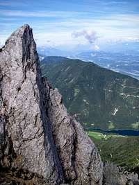
Towards the south Hochobir/Ojstrc shows a broad shoulder and only a small summit cone is more sharp. Towards the north, the view on the main summit is obscured by the broad fore-summit and only if you go a bit towards the east, a sharp, rocky mountain shows up. The most magnificient is the view from the west, where Hochobir/Ojstrc sends a broad rocky face, rugged and intermitted with many ravines.
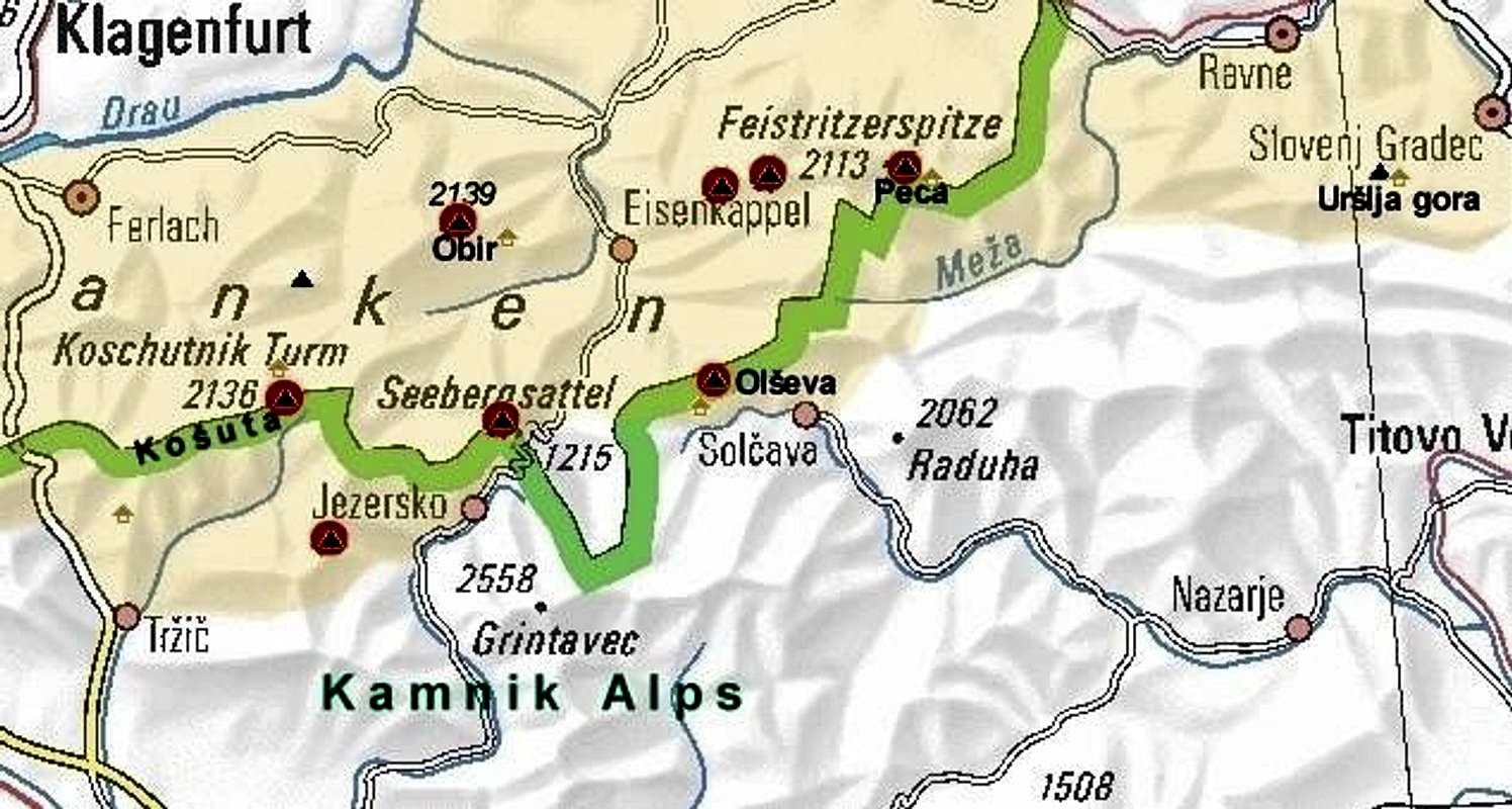
The northen border of Obir massif is the river Drau / Drava. The eastern and western borders are two creeks, flowing into Drau / Drava river: Vellach / Bela on the east and Freibach / Borovnica on the west. On the southern side, the Obir massif is attached to the rest of Karawanks on the Schaida / Šajda saddle, 1068 m. From this saddle towards the east the Ebriachbach / Obirski potok (creek) flows. While the mountaineering highlight of the massif is actually only the highest point, the massif consists of a few more summits. North of the highest point the Kleinobir / Mali Obir (Small Obir) stands, 1948 m. This summit obscures the view on the main summit from north, from the Drau / Drava valley. In the SW ridge there's an elevation, called Kuhberg / Kravji vrh, 2024 m, while the two other ridges, the SE and the NE ridge, carry only lower and less important elevations.
The summit of Hochobir/Ojstrc
Obir from the east
Hochobir/Ojstrc from the N
Mountaineering history
In previous centuries on many places on Obir led was mined. That's why the mountain was very frequented and criss-crossed by many trails. Miners' huts were also offering shelter to early tourists. Even if made of limestone, Obir is the only summit in Karawanks, where even above 1800 m water sources can be found. Just below the summit one such source is even on 2000 m. There were miners' huts as well and also the highest lying metheorological station in the former Austro-Hungarian empire. It was operating till 1846 and was famous because the observations, carried by its staff, described for the first time temperature inversion in mountains. The house was also a shelter for hikers, called Rainer Schutzhaus. It was burnt by partisans in September 1944.
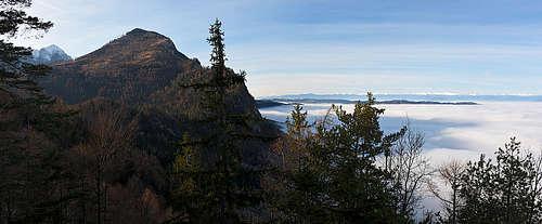
Wiews On The Massif From The Distance
From the South
From the South
From the West
Kleinobir / Mali Obir
North of the main summit a 200 meters lower shoulder rises, called Kleinobir / Mali Obir (=Small Obir). Its western and northern slopes are still steep and rugged, towards the South, a gentle summit plateau descends. Between the two summits there's a saddle, called Freibachsattel, some 1700 m, and on the western side of it the picturesque Jagoutz alpine meadow.
Kleinobir / Mali Obir is often ascended, as it is a great panoramic point and also the view on its taller brother is excellent.
Kleinobir / Mali Obir
The summit
Drava valley
A Bit Of Geology
The chain of Northern Karawanks, with Hochobir as the highest summit, belongs to the big geologic group of East Alpine mountains, the subgroup of the so-called Drauzug (Drau chain). The famous Periadriatic fault goes just south of it, by the Ebriach valley, thus separating Northern Karawanks from the Southern chain. The upper rocks of Hochobir are from triassic limestones, more precisely from the Wetterstein limestone (Ladinian, Carnian period). On the southern side, along the Ebriach valley and Eisenkappel basin, so on lower altitudes, narrow stripes of old crystalline and granite rocks are stretching towards the east.
What To Do There?
Wildenstein waterfall
The primary goal of most visitors of Obir is hiking by many of its paths. They are well marked and the summit offers a great panorama on the Karavanke / Karawanken chain and Kamnik Alps.
The massif offers also some nice ski tours. The most frequented is the route from the summit down to the Eisenkappler hut and further to Ebriach / Obirsko (the upper part - nice 600 m of downhill, below a forest road). Skiing is also possible in some other directions, also from Kleiner Obir / Mali Obir down to Jagovc farm (Sele-Hmeliše / Zell Homoelisch). Towards the W two more ski descents go: the descent through the NW ravine (Gipfelrinne, falling down from Obirscharte, 2100 m), is demanding (D- grade), doable only in ideal snow conditions. The other ski descent is by the Celovška riža, a ravine descending from the notch below Kuhberg. Finally, there's also the ski ascent/descend from/to Šajda/Schaida road pass.
On the northern side of the massif the Wildensteiner waterfall is a nice tourist attraction. In Slovenian language Wildenstein is called Podkanjska vas, so the waterfall is referred also as Podkanjski slap. It is 54 meters high and can be reached from the end parking place in some 15 minutes. They say that in 1348 earthquake a landslide blocked the creek, so water was redirected and started to fall over the rock step.
One of the greatest attractions of Obir is the nicely decorated karst cave, called Tropfsteinhoehle. Tourist visits are arranged from Bad Eisenkapel / Železna Kapla (bus + guided cave visit). The cave has no natural exit, so it was discovered by miners only in 1870. Here is the tourist page of the cave with bus schedules.
Türkenkopf ferrata entry
In the gorge of Vellach / Bela, in the Tabora narrows, just south of Eisenkappel / Železna Kapla town, there's a crag with a popular, but very difficult ferrata (Türkenkopf, D/E by the Austrian scale). You reach its entry across a small wooden bridge, on the other side is a parking place and the description plate.
Because of many abandoned mines in Bad Eisenkapel / Železna Kapla and in its surroundings, also fans of mineralogy will find many interesting sites.
The summit of Hochobir/Ojstrc can be reached from all sides by marked paths. Some of them are shown on the map above. Except from the south and from the Eisenkappeler Huette all approaches from valleys are long, but technically easy hikes (except the northern ascent).
The ascent from the Eisenkappler Huette (hut), 1553 m, is the most obvious and often done. From the parking place by the hut we go northwards and through a steep wood (a learning path, equipped with demo tables) to the plateau of Kraguljišče, 1828 m, from where we first see the main summit. Now we ascend towards W by a broad shoulder and over a short summit slope to the highest point. 1 h 30 min.
On the SW ridge of Hochobir/OjstrcThe route from Šajda saddle, 1069 m, is also often used. Good marked (yellow plates and usual red marks, No. 623) will bring you on the summit in some 3 hours. From the parking lot on the saddle, you begin walking up by the mountain road (closed for public traffic), but the path soon starts crossing turns of the road. We hike up by steep forrest slopes, but the path goes in wide turns and is so quite comfortable. On some 1600 m we leave the road for the last time (by wooden staircase). After some 100 m we reach a nice God sign and continue less steeply across the eastern slopes of Kuhberg / Kravji vrh, 2024 m. On the saddle betwen Kuhberg / Kravji vrh and Hochobir / Ostrc a broad panorama towards the NW opens. Now we continue by the main ridge or just below it to the summit. 3 hours.
The route from Wildenstein waterfall parking place is also very rewarding. It brings you by this nice waterfall, through the valley of Krtolovec and on the Eastern ridge, where it joins the route from Eisenkapeller Huette. 4:30 h - 5:00 h. You also don't need to go around, on the east ridge. From the meadow at the end of Krtolovec (Hofovška planina), you can go right (also marked) until in an hour you reach the ridge (saddle) above Jagouc alm (meadow). Then you continue on top by the north ridge (see below and the link).
Interesting is also the Northern ascent. To Jagovcevo sedlo, between Mali Obir / Kleiner Obir and the highest summit, we can ascend by a marked path, either from the west, either from the east. From there we follow southwards a tiny path, which later gets lost and we reach the summit in an easy climb (UIAA I). 4 hours from the valley, 1 hour from the saddle.
The northern villages below Obir massif can be reached by local roads of Drava/Drau valley. You deter from the Klagenfurt - Graz highway towards the south. To reach Bad Eisenkappel / Železna Kapla town you drive by the Vellach / Bela valley. From the southhern side, it means from Slovenia the town can be reached over the Seeberg / Jezerski vrh saddle, 1218 m.
The southern side of the mountain can be rached by a good local road either from Bad Eisenkappel / Železna Kapla (from the east) or from Ferlach / Borovlje (from the west). The valley below Obir is called Ebriach / Obirsko and consists of many picturesque settlements. High mountain farms are scatteres over broad, sunny slopes. From this valley the Obir panoramic road ascends up to the Eisenkappler Huette, 1553 m. It is opened from April till winter (depending on snow conditions).
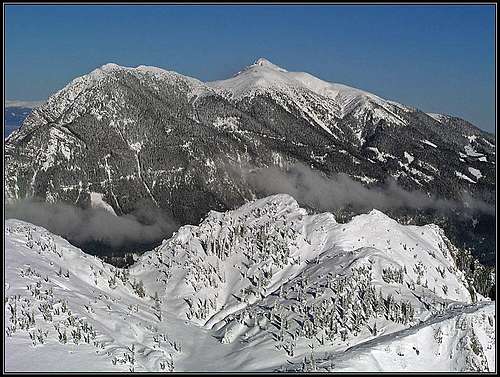
Because Obir massif is rising in the northern chain of Karavanke/Karawanken, it offers an immense panorama. Perhaps the most interesting is the view towards the west, along Karavanke/Karawanken chain. Great is also the view on Kamnik and Savinja Alps, we see this group from the northern side. Towards the north we see Gurktal Alps and in a clear day also Niedere Tauern, Dachstein and towards the NW Hohe Tauern. Below us, there is a nice landscape of Kaernten with several lakes and river Drau/Drava.
No restrictions. The Obir panoramic road must be paid during the season (€5,5).
Rechberg / Rebrca
Rochusberg panorama
This is a small, historical village, which, due to it's strategic position, played an important role in the middle ages and a bit later. It lies on a small plateau, which closes the exit of Vella / Bela creek valley, by which since prehistoric times an important trade route has been running. The gorge below the village was long unpassable, so all traders had to do the final steep climb into the fortified village. Above the village, since at least the 13th century also a castle was guarding the passage. Today, it can be hiked up, but it's all in ruins. Later, just above the village also a mansion and a commandery were erected, with a cute nearby church today forming a nice historical complex. Even higher, there's a panoramic hill, called Rochusberg (St. Rochus Peak), with a chapel and nice views around.
When To Climb
Hochobir/Ojstrc can be ascended any time of the year.
For weather see here and then choose on the menu: Kaernten.
Huts and Camping
The only alpine club mountain hut, supporting outdoor activities on Obir is the Eisenkappler Huette. It is opened also in winter if the weather is nice. Tel.: 0664 – 38 58 907, e-mail: orasche.hirtl@aon.at. Ask for Silvia & Marian Orasche.
Because of the Obir panoramic road, which reaches 1553 m, only to reach the summit camping is not needed.
Children refers to the set of objects that logically fall under a given object. For example, the
Aconcagua mountain page is a child of the 'Aconcagua Group' and the 'Seven Summits.' The
Aconcagua mountain itself has many routes, photos, and trip reports as children.
Parents refers to a larger category under which an object falls. For example, theAconcagua mountain page has the 'Aconcagua Group' and the 'Seven Summits' asparents and is a parent itself to many routes, photos, and Trip Reports.

 16697 Hits
 89.39% Score
 29 Votes