
|
|
Mountain/Rock |
|---|---|
|
|
46.90577°N / 10.23445°E |
|
|
Hiking, Mountaineering |
|
|
Spring, Summer, Fall, Winter |
|
|
9872 ft / 3009 m |
|
|
Overview
Geographical Classification: Eastern Alps > Silvretta Group > LareinfernerspitzeThe Lareinfernerspitze / Piz Larain is a 3009 meters high summit of the Silvretta Group. The summit is located in the Fluchthorn Group, named after the heighest summit, the Fluchthorn (3399 m). The summit lies just north of the Fluchthorn and south of the Heidelbergerspitze (2963 m). On the western side of the summit you'll have the Jamtal Valley while the Fimbatal Valley is located at the eastern side of the mountain.
The summit isn't very prominent because of it's much higher southern neighbour mountain. Due to the easy climb and acces to the mountain it is pretty popular in both summer and winter. The normal route is a 3 hour scramble from the Heidelberger Hut. The main starting points to reach the hut are the famous skiresorts Ischgl and Samnaun. Unfortunatly the acces roads from these villages run
partly through the ski area. More interesting information about the ski area and it's concequences can be found on the excellent
Palinkopf SP-page.


Getting There
In General: There's only one common starting point to get to the summit: the Heidelberger Hütte. This starting point of the climb can be easily reached from the Paznaun valley in Austria. Enter the Paznaun valley just west of Landeck and take Silvretta Hochalpenstrasse (B188) to reach the famous skiresort Ischgl.Other ways to reach the Heidelberger Hütte, from Switzerland, are a bit longer.

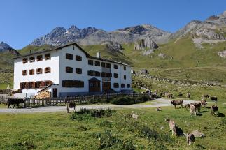
Source: www.heidelbergerhuette.com
Heidelberger Hütte 2264 m
Fam. Huber
Seichle 422
6555 Kappl
Telefon Hut: 0043/664/4253070
E-Mail: info@heidelbergerhuette.com
www.heidelbergerhuette.com
Getting to the Heidelberger Hütte
From Austria:
1. Common acces from Ischgl. start from the church in Ischgl to enter the Fimbavalley. Follow the road through Fimbavalley along Bodenalpe to reach the hut (Partly possible with cable car and backpack transportation possible!). Total: 4 hours.
2. From Mathon (Wildpark Silvretta). Enter the Larainvalley on a large path through the forrest. Follow it to Lareinalpe (Can be reached by Taxi). Continue to a small custom-house. Turn left just before the custom-house and climb to Ritzenjoch (2690 m). Descent along a good path to reach the hut. Total: 4 - 5 hours.
From Switzerland:
3. From Samnaun, taxfree shopping paradise. Enter the Val Musauna and take the marked path to the Zeblasjoch (2539 m), Swiss/Austrain border. Continue to Piz Val Gronda (2752 m) and descent to the hut. Total: 4 - 5 hours.
4. From Ramosch in Val Sinestra. On a sandy road to Weiler Zuort (Taxi transfer possible). Continue to the Val Chöglias to reach the Fimberpass (2608 m). Descent on a well marked path to the hut. Total: 4 - 5 hours.
5. From Scoul. Take the cable car and ascent towards Mot da Ri and F. da Champatsch (2730 m). Along marked path (302) through Val Laver, along Fuorcla Davo Dieu (2807 m) to the hut. Total: 4 - 5 hours.
Routes
Normal route from Heidelberger Hütte Map of the Lareinfernerspitze
In summer: because of the hill-shape of the mountain on the Fimbavalley side there are various possibilities to reach the summit. Most common are the routes from Heidelbergerscharte (2819 m) and Lareinfernerjoch (2853 m). For practicing you route finding and climbing skills it also possible to find your own way directly from the hut to the summit.
Starting point: Heidelberger Hütte (2264 m)
Highest point: summit of Lareinfernerspitze(3009 m)
Height gain: 745 m
Time: from the hut to the summit about 2 - 3 hours.
Difficulty: T3, no rope required.
In winter:
As I've mentioned before, the Lareinfernerspitze can also be climbed in winter. For more information (in German) see this page: www.heidelbergerhuette.com
 Lareinfernerspitze in winter
Maps and Guidebook
Map 1:25 000:- Silvrettagruppe
Alpenvereinskarte 26
(summer and winter edition available)
- Silvretta-Verwallgruppe
Kompass Map WK41
ISBN: 3-85491-047-9
- Silvretta Hochalpenstraße, Piz Buin
Freytag & Berndt WK373
EAN: 9783850847735
- Silvretta Alpin
Günter Flaig
Alpenvereinsführer
Rother Verlag
ISBN: 3-7633-1097-5
To order Freytag & Berndt maps: www.freytagberndt.at
To order the Rother Wanderführer: www.rother.de
To order the Alpenvereinsmaps: www.alpenverein.at
External Links
* Weather forecast* Avalance Bulletin
* Time Table Bus
* Time Table Train