Introduction
![Tribulaun Group]() The Tribulaun Group as seen from Hoher Lorenzen in its east The Tribulaun Group as seen from Hoher Lorenzen in its east |
I want to avoid misunderstandings right from the start: the Brenta in question here is the mountain range of the Brenta Dolomites, not the SP-member of the same name. Thus the look-alike I am going to present in this trip report also is a mountain range, but of considerably smaller proportions: the Tribulaun Group on the
Stubai Alps Main Ridge. You can make comparisons with the help of the pictures but the real feeling is spared to those who visit both groups.
But before I plunge into the tale I should start with some words about said Brenta Dolomites. The range, though composed of Dolomite rock, is not considered to be part of the Dolomites themselves, probably mostly because it is located some 40 km to the south-west. It is famous for its towers and spires, famous for its huge vertical faces with great climbing possibilities, famous for the ledges which run straight through said vertical faces and famous for the vie ferrate, the secured “climbing trails” which crisscross the whole range. Finally, the range is also famous for its fogs, which happen to roll over it, whenever you are in its more picturesque places. Pure Dolomite I would call it, maybe purer than most mountain groups in the “real” Dolomites. What always struck me, however, was that when seen from afar the Brenta Dolomites lose their features. While other Dolomite Groups are readily distinguishable from the outside the Brenta Dolomites look like a long stretched rounded range. The real beauty lies within!
If you promise to return here, I recommend you to take a look at the
Brenta Dolomites page before proceeding.
And now we’re off to the Tribulaun Group…
The Birthplace of the Dolomites
So here we are, some 70km north-west of the Dolomites, about 5km to the west of the Brenner Pass. We are on the main ridge of the Stubai Alps, which starts at Brenner and ends at Timmelsjoch / Passo del Rombo. A curious ridge it is: mostly made up from brightly red micaceous schist, it nevertheless contains large layers of marble and limestone. And here, between Pflersch / Fleres and Gschnitz you find pure Dolomite.
That this rock is called Dolomite dates back to 1788 / 1789, when a French geologist, Dieudonne Guy Sylvain Tancrede Gratet de Dolomieu, visited the area and started to investigate the various different rocks. He found out that the rock of the Tribulaun Group, though resembling limestone, lacked some of its usual qualities: there was no water contained in the rock and in contrast to other limestones, treating it with acids didn’t produce any gases. One thing led to another: the rock was called Dolomite and 80 years later a whole region was called “the Dolomites”.
Curiously enough, its birthplace was excluded…
Tribulaun
![The principal summits of the Tribulaun Group]() The Tribulaun Group summits seen from Roßkopf
The Tribulaun Group summits seen from Roßkopf
But let’s get back to the Stubai Alps Main Ridge. At its eastern end it turns into Dolomite and it is here that you find the Tribulaun Group. Three Valleys run towards that group from the Brenner Pass Road: Pflersch Valley / Val di Fleres, Obernberg Valley and Gschnitz Valley. The latter two are on Austrian ground while the former is Italian. Each of these valleys has its own Tribulaun, a massive Dolomite mountain of about 3000m, which dominates its valley end. The lowest is Obernberger Tribulaun at 2780m. It is also the easiest to climb with two marked and secured trails. Gschnitzer Tribulaun reaches 2946m and can be reached by an old ferrata. The highest of the three – and also the highest mountain of the small group is Pflerscher Tribulaun (3097m), a massive double-peaked summit, which drops off vertically on all sides. When seen from afar, only this mountain stands out among the peaks of the group.
Outside Glimpses
![Pflerscher Tribulaun]() Pflerscher Tribulaun behind Wetterspitze (right)
Pflerscher Tribulaun behind Wetterspitze (right)
In September 2006 we spent three weeks near Sterzing / Vipiteno, where the Stubai Alps, Zillertal Alps and Sarntal Allps meet. Right on the first day, when we did the whole Jaufenkamm traverse in the very south of the Stubai Alps, Pflerscher Tribulaun raised its head above the ridges in between. The double peaked summit was clearly visible at all times, a summit, which locally (and formerly) was called “die Schaar” – the scissors.
![Tribulaun Group seen from Telfer Weißen]() The Tribulaun Group as seen from Telfer Weißen
The Tribulaun Group as seen from Telfer Weißen
Two days later saw us standing on Telfer Weißen on the southern side of the Pflersch Valley. Undoubtedly there is no better place to look at the Tribulaun Group. The main summits are clearly visible and you can almost feel that 2000m drop into the valley underneath. Also you can see some of the hiking paths and ferrate in the group as well as the passes, which all are part of the ascent routes to the summits. Further days gave us additional views and we decided to take a closer look.
![Pflerscher Tribulaun]() From Portjoch From Portjoch | ![Pflerscher Tribulaun]() Pflerscher Tribulaun Pflerscher Tribulaun | ![Tribulaun Group]() From Ganskragen From Ganskragen |
Lakes and Ridges
![Obernberger See and Obernberger Tribulaun]() Obernberger Tribulaun
Obernberger Tribulaun
At the end of Obernberg Valley, just underneath its Tribulaun, a large lake, Obernberger See, serves as trailhead for a number of trails into the sobgroup. On Sept 22nd we decided to start there on an exploration of the easternmost part of the Stubai Alps ridge. This tour would take us to Portjoch saddle and from there on along two ridges and five summits. While not leading inside the Tribulaun Group itself (Portjoch is its eastern boundary) it would offer close-up views of the summits in its midst. The weather was fine and expectations were met.
We started from the large parking lot at the end of Obernberg Valley. I paid an 8h parking fee not believing I would be evading payment – like it turned out in the end. A 30 min hike took us to the lake and though it was still rather early the lake shore was already crowded with people. We didn’t stay long – just a couple of photos of the mountains in the lake mirror – and headed on to Portjoch saddle. There we were too close for the Tribulauns but the Dolomites and Sarntal Alps Panorama was developing in front of our eyes. Unfortunately, however, the day was hazy and most of the summits were still only barely visible from our lookout.
We turned east – away from the Tribulaun Group – and started to climb the ridge towards Grubenkopf. Here we found anachronism in the times of open European borders: a barbed wire fence between Italy and Austria. The bleating of goats, a couple of minutes later, explained the fence however. We reached Grubenkopf around noon and finally turned around to get this beautiful view of the Tribulaun Group from up close:
![Tribulaun Group seen from Grubenkopf]() Tribulaun Group from Portjoch
Tribulaun Group from Portjoch
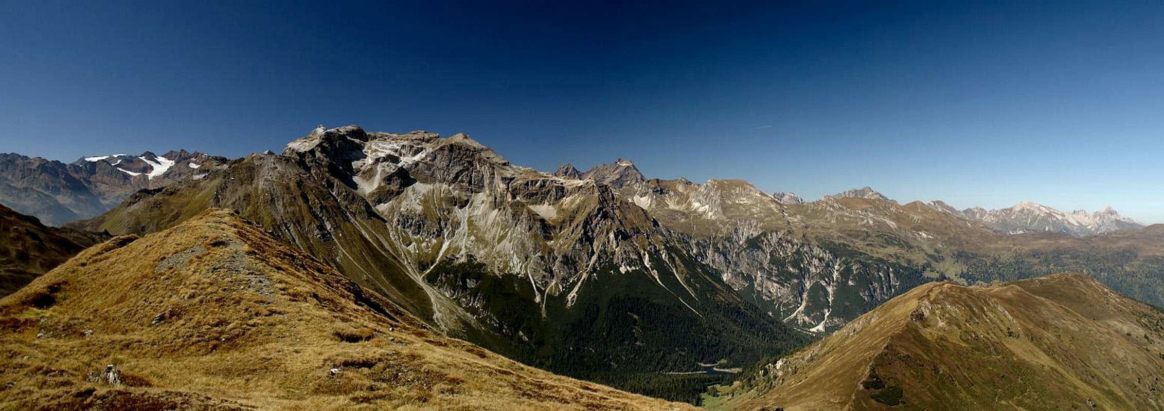
Time for lunch and time for a 360°-panorama – but we still had four summits on our agenda. Geierskragen was the next, then Hoher Lorenzen, a mountain that also can be reached from Brenner Pass, so that we met our first and only crowds up there. Hoher Lorenzen was the easternmost point of our loop and somehow we could see the whole loop from up there. The Tribulaun Group was glistening in the early autumn afternoon sun.
The Tribulaun Group as seen from Hoher Lorenzen |
From Hoher Lorenzen we headed down the “Lakeview Trail” (you only see parts of Obernberger See) and across the summits of Koatnerberg and Allerleigrubenspitze, always with the Tribulaun Group to the west and the Tux Main Ridge of the Zillertal Alps to the east. We took our time enjoying the views because soon enough we would get below the timberline again and then the views would be lost. Allerleigrubenspitze turned out to be another perfect lookout peak but then we plunged into the woods. After 8 1/2h we emerged somewhere near our parking lot. The batteries of camera and GPS receiver had given up and we ourselves barely managed the last meters. But anyway we decided to go to the inside of the group anytime soon.
![Tribulaun Group from Allerleigrubenspitze]() Summit View Allerleigrubenspitze
Summit View AllerleigrubenspitzeFinally: From the Inside
The choice was Garklerin, a summit on one of the northern ridges of the Tribulaun Group. It can be reached from the end of the Gschnitz Valley along a protected chimney climb. However weather turned to the worse and since the forecast called for nicer weather in the south the tour was postponed, then abandoned. We did some fine climbs elsewhere, but always had to deal with low hanging clouds.
![During the only short break in the clouds: Pflerscher Tribulaun seen from Sandsee]() Pflerscher Tribulaun seen from Sandsee
Pflerscher Tribulaun seen from Sandsee
Finally, on the last day of the vacation – we headed to Pflersch, trying to climb to Sandjoch in the heart of the Tribulaun Group. The weather forecast still called for fog and low clouds but this was our last day and we were determined to finally get inside the group. To the west of Pflerscher Tribulaun you find the Italian Tribulaun Hut near Sandsee and this was our first destination. If Sandjoch couldn’t be reached because of the clouds we wanted to turn onto Pflerscher Höhenweg which crosses the slopes south of the main summit of the group.
It turned out that we had to do just this since clouds were rolling in from the south-west. The summits of the next crest to the south, Maratschspitze and Hocheck only made short appearances, then vanished in a cap of clouds again. Pflerscher Tribulaun, the main reason for our climb, was invisible from the start, only now and then one of the towers around its bases would pop out of the fog. Also, even the cirque, in which Sandsee and the Tribulaun Hut are located, was hidden from sight. We made haste – that way we would have ample time at night to pack our things and make ready for the drive back home the next day.
![Rolling Clouds: Tribulaun Hut in front of the west face of Pflerscher Tribulaun]() Tribulaun Hut among the clouds
Tribulaun Hut among the clouds
We arrived at the hut around 11 a.m. A small patch of blue sky made us hope for a short break, which might enable us to reach Sandjoch – but soon the world turned black around us. The group seemed to deny access and wanted to evict us. A bit frustrated we retreated. There was only one short glimpse of the 1000m wall of Pflerscher Tribulaun, a sight I had hoped to see so much, and now I was directly underneath it but couldn’t see a bit!
Pflerscher Höhenweg
![Pflerscher Höhenweg]() Pflerscher Höhenweg underneath the Tribulaun south faces
Pflerscher Höhenweg underneath the Tribulaun south faces
So now we descended a bit and reached the intersection to Pflerscher Höhenweg. From our map we saw that it ran along underneath the very south face of Pflerscher Tribulaun. We had hoped for some impressive sights but in this weather – what was there to hope? We crossed a scary steep scree field and each time a the south face would pop out of the fog I tried to take a photo. These occurrences happened more and more often and I got the impression, that the group – once it had got rid of us – was preparing for good weather. It was here that the similarities to our Brenta experiences started to strike me. There we also had had fog on and near the summits and perfect weather underneath.
![The rests of a snowfield in September]() Snow in September Snow in September | ![Pflerscher Tribulaun South Face]() Switchbacks beneath the walls Switchbacks beneath the walls | ![The Tribulaun South Faces]() Pflerscher Höhenweg Pflerscher Höhenweg |
Also, the trail somehow reminded me of the ledges I had hiked three years before, and thanks to the ever improving weather we really started to see where we were going. Huge vertical faces loomed above us, a small snow field (on the south face!) remained in one of the gullies and goats accompanied us on our way. We reached the point were we had planned to leave the panoramic high trail and had lunch. It was still early – thanks to our efforts in the morning and I proposed to hike on a bit further. There would be another trail heading down the mountain several kilometres further on, it would join the trail we had originally planned and time was no issue. Furthermore, a high trail is supposed to run along at more or less the same elevation, isn’t it?
![The south-easternmost rampart of Gschnitzer Tribulaun]() The southernmost wall of Gschnitzer Tribulaun
The southernmost wall of Gschnitzer Tribulaun
I sould have known! It’s always like this and especially on the last day of a vacation! The trail remained level at first – there were several ferrata-like secured stretches and once we had to descend into a gully and climb out of it again. But as we neared the place where we thought our trail would take us down again we realized that now the real tough part would start. We needed to descend into a narrow creek valley, with very loose scree under the soles of our boots, then scramble up this valley to a point, where a secured ledge led us out on the other side. Then climb up a steep slope, only to zigzag our way back down into Pflersch Valley.
![Pflerscher Höhenweg]() Climbing out of one of the gullies
Climbing out of one of the gullies
We cursed! But what was there to do? We went along with the programme and in the end – were happy we did. As we started to climb out of the creek bed we realized that the clouds had retreated and that more and more rocks were starting to be visible around us. Moreover the creek bed had taken us to the inside of the Tribulaun Group, which is where we originally had intended to go. We were a cirque further to the east than we had planned to be but so what? Maybe we were a bit too close to the mountains now but our way back into the valley would change that.
![Gschnitzer Tribulaun east face]() The east face of Gschnitzer Tribulaun
The east face of Gschnitzer Tribulaun
As we zigzagged downwards each switchback on the way offered better and better views towards Pflerscher Tribulaun. Its summit was still in the clouds but the lower walls rose above us. Also, Schwarze Wand and some of the towers south of Gschnitzer Tribulaun were visible as well as the west and south faces of Nördlicher Roßlauf. We descended further down and just before the trees swallowed us we had a great view into the group.
![Schwarze Wand]() Schwarze Wand Schwarze Wand | ![South-west faces of Nördlicher Roßlauf]() Roßlauf west face Roßlauf west face | ![The Tribulaun Group from the near outside]() Tribulaun Group Tribulaun Group |
Now it was getting late and cold and we still had about 800m to descend, then get back up to the place the car was parked. The mountain shadows lengthened and soon everything was dark again. It took forever to get down to Innerpflersch, the village at the end of the valley. When we did, the Tribulaun Group loomed above the village and in one of the rare spots where we had some sun I took a last shot.
![Pflerscher Tribulaun]() Pflerscher Tribulaun above the village of St. Anton
Pflerscher Tribulaun above the village of St. Anton
All’s well that ends well – and this day had ended well enough – though the beginning had been less than promising


Comments
Post a Comment