
Comments
No comments posted yet.
|
|
Trip Report |
|---|---|
|
|
45.98861°N / 9.23366°E |
|
|
Nov 30, 0000 |
|
|
Hiking |
|
|
Summer |
We had travelled to Lake Como at the height of summer to celebrate my birthday. Neither of us had been there before and as this was only a short, 5-day break, we knew we would only get a couple of days that we could go walking.
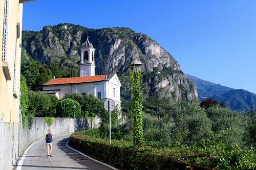
Having just arrived from the UK, we explored the area around our hotel in Cadenabbia. Walking along the lakeside in bright sunshine, we spotted a white church high on a hillside and standing below a huge rockface. Chiesa di San Martino sits above the hamlet of Griante, looking across Lake Como towards the Bellagio peninsula. It is a popular destination for many tourists visiting the area and is a good rest stop on the way to the top of Sasso San Martino. The weather was hot, so we decided to start early the following morning.
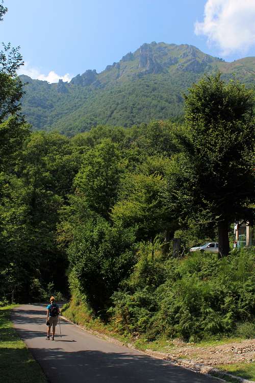
At 8.20 am it was already quite warm as we left the main lakeside road and set off up a steep alleyway.
“I’m going to take this slowly” Marie said as we ascended the small but steep steps.
From the lake side, there are several ways to start this route, all the route options start off steeply. We were starting from near the Grand Hotel.
It was warm but we were in the shade of the surrounding buildings which offered us some coolness. We had found this route up the Passeggiata Adenauer the previous day, it was well signposted to San Martino and followed mainly cobbled footpaths until we reached a carpark at the end of a narrow but drivable road.
Ahead, we could see San Martino on the hillside as we walked through the quiet streets and our route took a more or less direct line towards it.
We paused at Chiesa dei Santi Nabore e Felice to read an information board on the origins of the church and then, headed straight on following a sign for San Martino which took us on a path through an arch in a house and on to a road. Turning left here, we continued down the road before leaving this at a sign directing us onto a cobbled path.
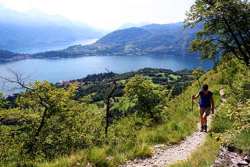
It was clear that this path had been constructed and maintained for anyone who wanted to visit the church. It was wide and in good condition and along the way, there were shrines containing scenes depicting the stations of the Cross which we passed at regular intervals. The path gradually gained height, shaded by trees we got tantalising glimpses of the lake as we got higher. The trees seemed to be full of Crickets chirping loudly although, we never saw any of them.
We passed the First World War memorial at Cappella degli Alpini, a peaceful chapel with a lovely viewpoint complete with interesting murals inside depicting soldiers struggling through the winter in the mountains.
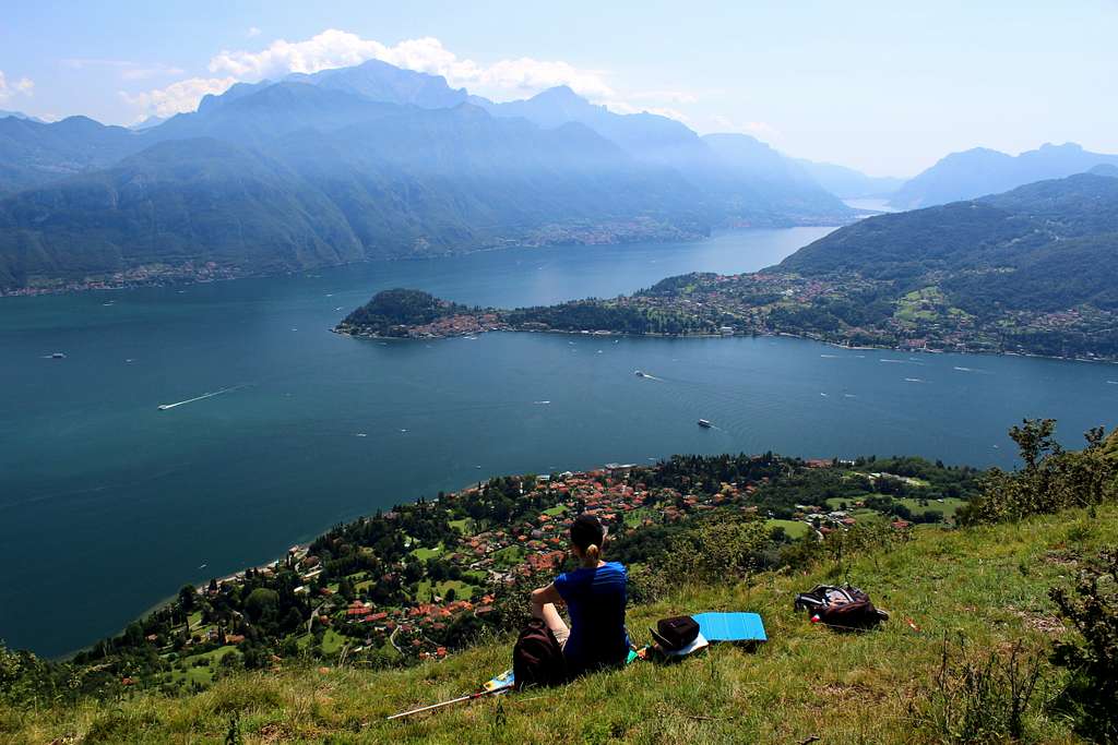
Although it was Sunday and there were a few people heading down as we went up, no one was going up with us. The trees started to thin out and as we traversed the hillside towards San Martino, we got our first clear views of the lake.
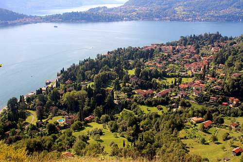
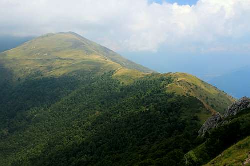
Immediately beneath us were the large (and expensive looking) villas with even larger formal gardens. Then, the expanse of Lake Como itself and on the opposite shore, the town of Bellagio, set on a peninsula. Behind that, we could just see the other “leg” of Lake Como and then the mountains of the Grigna massif with Grigna Settentrionale being the highest point at 2410m. The view to the mountains was a little hazy looking into the sun.
Chiesa di San Martino was originally built in the 16th century but when a wooden statue of the Madonna with child was found on the mountainside, it was enlarged to house this statue in the 17th century.
The church of itself was locked when we visited but a small hole has been made in a window for those who would like to see inside. We sat outside in the sunshine and admired the view.
“Look at that one with the circular swimming pool”, Marie pointed to a castle-shaped villa with swimming pool in its garden.
The sound of church bells from the town drifted up to us above the hum of the lakeside traffic and the occasional horns from the ferries.
After a rest, we left the peace of the churchyard and re-traced our steps along the path. Where the main path descended, we carried on upwards on a smaller path towards some summer houses. After we passed these, we started up the zig zag path which ascends the hillside steeply.
Soon the trees ended and we were out in the open and heating up in the full sun!
The path was quite rough but had no difficulty
“What’s the hottest route we’ve done?” I asked Marie as we stopped for a drink.
“That last day in Gran Canaria? Coming down from Mt Toubkal? What about Montenegro? Marie came up with several possibilities. This started an ongoing conversation about the hottest, longest and best days we have had in the mountains as we toiled upwards.
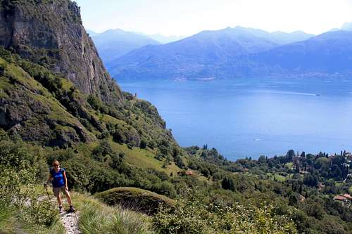
Every now and then we would stop to admire the view which, although it was essentially the same one, changed as we gained height. The church at San Martino was below us for a while before it was lost around a spur of the hillside as the path moved further around a corner.
We stopped frequently for more fluid and admired (and tried to photograph) the many different butterflies we saw fluttering around us. I’m familiar with the ones that are common in the UK but I didn’t recognise these brown and white ones. We did see a Swallowtail butterfly just once. We were also accompanied by birds, particularly Swallows wheeling in the summer warmth to catch insects.
After a while, we reached some old farm buildings and followed the path in front of them. We had originally planned to go up to the summit of Sasso San Martino but somewhere here we missed that path and continued onwards, upwards and away from this top. By the time we had realised our mistake, we didn’t want to have to lose the height we had gained to return.
Continuing, we reached the highpoint of our route at Il Dossone (885m) and found an open hillside to sit and admire the view. As well as the view across Lake Como we had before, we now had extensive views northwards to the end of Lake Como (towns?) and the snow-capped mountains around St Moritz. At last, we had a breeze and as we ate some lunch, we realised we had to start rationing our dwindling water supplies.
Sitting in the warm sunshine, it was a lovely, quiet spot.
“Not a bad way to spend a Sunday?” Marie commented.
Behind us, we could see the summit of Monte Crocione (1641m) above us and too far away to reach today.
We finished lunch and headed down westwards through the trees to join the long-distance footpath “Via Monti Lariani” and follow this north and down towards the village of Croce.
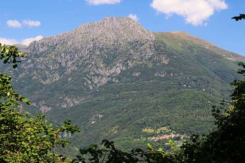
Ahead and across the valley we could see the summit of Monte Grona – our target for the following day - shimmering in the sun and gradually as we walked, we returned to civilisation, passing the chapel of Madonna di Paullo.
Back into the heat and noise of Mennagio we got the short bus ride back to Caddenabia.
We got off the bus in the quiet village of Breglia, set in the mountains above Mennagio and at the end of a road with a long series of hair pinned bends.
Marie studied the return bus timetable whilst I checked the map for our route.
“There is a bus at 4.00pm, the next one after that is at 6.00 pm. So, we need to get the earlier one”.
I looked at my watch, it was 9.05 am. “We have 7 hours, should be enough!”. I said.
Again, it was a warm morning and our route started up the toll road. As the road zig zagged upwards and cars passed us regularly heading upwards, our route cut corners through the woods on rough, stony paths.
It was very humid and instead of the clear views of the previous day, it was very hazy. Lake Como sat beneath us, the lakeside showing as a hazy border between the land and the water.
We had learned our lesson from the previous day regarding water and I carried 2 ¼ litres whilst Marie carried another ¾ litre for the day. Only trouble was that my rucksack was much heavier than normal and in the heat, I was soon sweating.
It seemed to be ages before we finally passed the car park at the top of the road and found a number of groups just setting out. Most of the people we saw seemed to be heading to the Rifugio Mennagio for lunch and we managed to overtake quite a few when they stopped for a breather.
Soon the trees thinned out and we got a view. The rifugio seemed to be at more or less the same level as us on a spur of the hillside. We set off towards it and arrived there about 10.30 am.
After a stop for refreshments, we continued. Above the rifugio there were several signposts and at first, we took the wrong one, taking us around the south side of the mountain. Returning to the rifugio, we ascended a little higher and found a choice of routes between the “direttisima” and the “normale”.
“I’m not going very well today” Marie said. “I’m going to stick to the easy route.”
We weren’t sure what the difference between them would be but I decided to head for the “direttisima” and Marie headed for the “normale”.
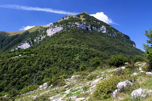
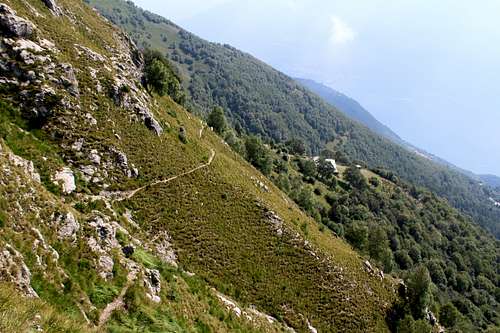
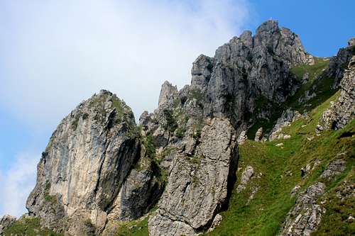
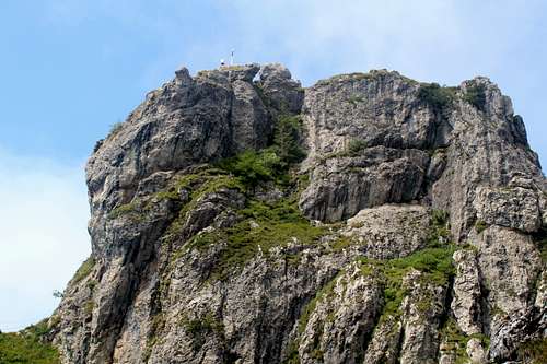
The “direttisima” headed across the hillside on a narrow path that contoured around towards a rocky, limestone ridge. I reached the ridge and could see over to Lake Lugano in the hazy, distance. In the foreground, a steeper, rocky ridge had several pairs of climbers on it, this was obviously the ferrata route to the summit, “Ferrata Centenario CAO”.
My route followed a steep, rocky path up the grassy gully to the right of the ridge which has the ferrata. On a square outcrop at the top, I could see the white cross showing the summit.
There appeared to be no one else on my route and as I expected to have to do some scrambling, I packed away my walking poles and set off upwards. The going was mainly steep walking with the occasional outcrop of rock that needed to be scrambled up. Every now and then, I stopped to watch the ferratistas on their route – it looked hard!
|
|
I paused to catch my breath. I didn’t really feel completely “mountain fit” but as it was only our second day in the mountains, I put it down to that.
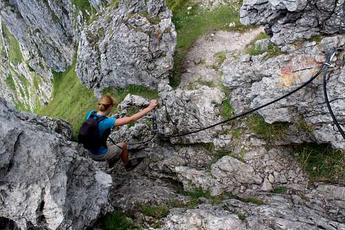
Towards the top of the gully, the path veered towards the rocks on the right and steepened, there was a bit more cable protected rock to scramble up but I soon reached the top.
I briefly spoke to a couple sitting there, then I walked to a nearby viewpoint and saw Marie coming around a corner along the “normale” route, a minute later she arrived. It had taken us both about an hour from the rifugio.
|
|
We scrambled up to the summit rocks using the fixed cables and found a place to eat our lunch. The breeze was warm and did nothing to disperse the hazy cloud that hung around the mountain tops, there were a few other people there.
“On a clear day you can see the Monte Rosa…” someone said. Unfortunately, today we could barely see across Lake Como!
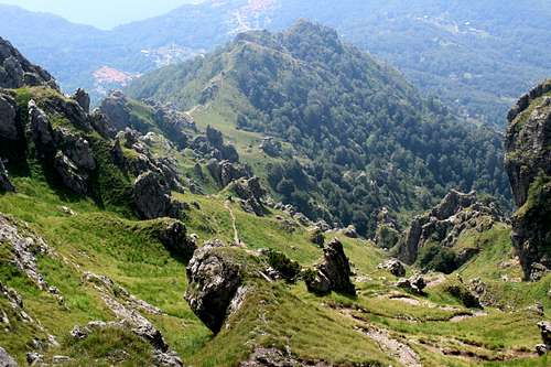
The view towards Lake Lugano and (town) was very hazy and even Mennagio beneath us was rather vague.
“I think I should have come up with you”, Marie said as she looked down on the “direttissima” beneath us. “The “normale” had scrambling on it as well and your route looks shorter.”
“It was mainly a steep path”, I replied by way of explanation.
We finished our lunch and scrambled back down the cables, returning along the “normale” route.
The main difference between the two routes seems to be that the “direttissima” takes a steeper and more direct line. It isn’t more difficult and there is a similar amount of rock scrambling on both.
We reached the Forcoletta and instead of descending from there, we decided to continue along the ridge in front of us towards the San Amate chapel. The ridge here is broad and grassy with no rock outcrops and few trees. It continues upwards towards Monte Bregano (2107m) beyond but according to our guide book, this was an extra 2 ½ hours round trip so we didn’t have time for that as well.
Instead, at the San Amate chapel, we turned downhill following a grassy path downwards and back across the hillside towards our ascent route. Again, we chased butterflies with our cameras and tried to step gently as the grass was teeming with grasshoppers of all sizes and colours, jumping as we descended through them.
We re-joined our ascent route and descended quickly to the car park at the end of the road. For a while, we stayed on the tarmac rather than use the steeper, rougher shortcut paths. Soon the road returned us to Breglia with 40 mins to spare before the bus was due to arrive. We had an anxious 5 minutes at 4.00pm when it failed to appear but it was just late and our driver hurtled down the narrow roads to try and make up the time on the way back.
A hot and enjoyable day.