
-
 6488 Hits
-
 79.04% Score
-
 10 Votes
|
|
Mountain/Rock |
|---|---|
|
|
28.62408°N / 17.84183°W |
|
|
Hiking |
|
|
Spring, Summer, Fall, Winter |
|
|
4468 ft / 1362 m |
|
|
Overview
 Montaña Quemada seen from Cumbre Vieja Montaña Quemada seen from Cumbre Vieja |
Montaña Quemada is a small mountain, which barely stands out from Llano del Jable (the sandy plain) in the centre of La Palma among the Islas Canarias. The mountain is overshadowed by both the Cumbre Vieja and Cumbre Nueva Ranges, beneath which it is located somewhat close to their connection point. Its very summit is covered by Canarian Pines so that you need to step down a bit to the west in order to get a glimpse of the fantastic view towards Caldera de Taburiente, the island's giant erosion crater. In all, Montaña Quemada appears to be a harmless mountain.
 Llano del Jable
500 years ago this surely was different. During two eruptions, one in 1470, one in 1492, Montaña Quemada emitted huge amounts of lava from its crater. Much of this lava was emitted as small Lapilli, the tiny volcanic cinder particles, and covered the area in the ultimate vicinity of the mountain with a thick layer of black sand. The plain, which was created by this ashen blanket was called Llano del Jable, a name it still bears today. The cinder covered much of the fertile ground to the east of the town of El Paso, bringing farming to a standstill. Farmers had to switch to different crops, first wine, later mulberry trees. You can say that Montaña Quemada laid the foundation of the Palmeran silk industry of the outgoing 18th and early 19th century.
 |  |  |
Thanks to the prevailing trade winds, which sweep the island from the north-east, most of the cinder was deposited to the south-west of the mountain while the lava flows followed the incline and flowed in the opposite direction. Here, the lava flowed through a kind of deep canal towards the outskirts of El Paso, where it piled up in huge brittle walls. Even today this Malpais (bad land) cannot be used for anything thoug it serves many species of birds and lizards as a safe home. You can witness the Malpais best, when you use PR LP 14, the hiking trail which leads from El Paso to Llano del Jable. Montaña Quemada has a lower and older neighbour, Montaña de Enrique, which also contributed to the lava flows. Today it is completelly covered in pines, which beautifully contrast from the black plain of the Llano.
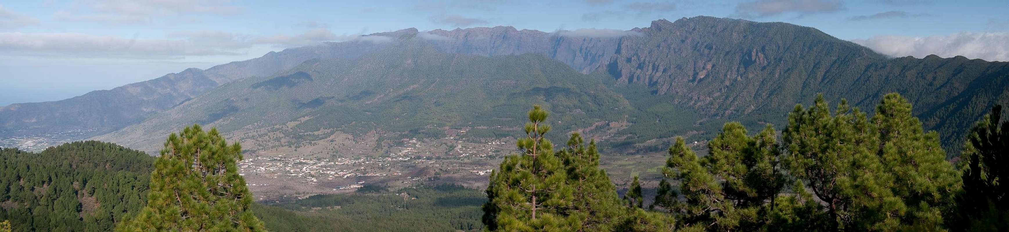
Summit Panorama
  |
Getting There
 Montaña Quemada, Montaña de Enrique
La Palma, like all the other Canariy Islands can easily be reached from almost all major European airports. The airport is rather small and compared to Tenerife or Gran Canaria air traffic is rather low. There are almost no regular flights but all year round you'll be able to book charter flights.
Montaña Quemada is located close to LP-203, the road which leads from El Paso to Rifugio el Pilar. The road winds through Montaña Quemada's lava flows before reaching Llano del Jable.
To reach the mountain head out northward from the airport on LP-1, which you leave at a roundabout, heading in the direction of Los Llanos along LP-2. You cross the Cumbre Nueva through the long Cumbre Tunnel and immediately afterwards (the two lane road combines into a single lane) turn onto LP-203 southward. Follow the road up to Llano del Jable. There is no parking lot but a good number of cars can be parked to the side of the road.
Red Tape
 Gallotia galloti palmae
The mountain is part of the Parque Natural de Cumbre Vieja. Inside park limits in principle you are not allowed to leave trails nor to camp. However, Llano del Jable at the base of the mountain has become quite a popular spot for walking dogs, jogging and similar recreational activities. Also, the dirt roads which cross the plain can be quite busy with the pickups of the local farmers.
There is no path to Montaña Quemada's summit though on maps you can find indications for one. Thus, it actually might be off-limits.
Accommodation
 Llano del Jable
There is a camping zones near Rifugio del Pilar quite close to the mountain. For reservations either ask at the rifugio or contact the Centro de Visitantes de la Caldera de Taburiente in El Paso.
Different types of accommodation are no problem. Every European travel office will be able to book hotels, rooms and apartments for you. I won't include any links here because all of them definitely are commercial. Another option is to rent a finca (rural house) from the owners directly. You'll have to google for these but sometimes prices are low enough for the scheme to be worthwhile.
Weather Conditions
 Llano del Jable
Usually all year round the Canarias have the same weather with little alterations: north-eastern trade winds which deposit fog and dew on the north-eastern slopes of the islands. The western and southern parts usually are very dry and there you'll get some hours of sunshine each day. Especially on the higher islands like La Palma you usually don't have to worry about weather too much. The mountaintops will stick out of the clouds.
There are no reliable weather forecasts for the mountain regions of La Palma. Often a cloudless day turns into a foggy one within half an hour. Especially the Cumbre Vieja Range is prone to these fogs and here orientation among the lava and scree fields gets very difficult. This is the main reason why you should never leave the trails there.
Forecasts for the coastal regions, however are available. You have to subtract 1°C for every 100m of altitude so that Roque de los Muchachos will still be near freezing when the coasts have already fine and sunny beach weather. The following table gives a little overview about the average weather data of the capital of Santa Cruz:
| Month | Jan | Feb | Mar | Apr | May | Jun | Jul | Aug | Sep | Oct | Nov | Dec |
| Avg. day temp.[°C / °F] | 21 / 70 | 21 / 70 | 22 / 72 | 22 / 72 | 22 / 72 | 24 / 75 | 25 / 77 | 26 / 79 | 26 / 79 | 26 / 79 | 24 / 75 | 22 / 72 |
| Avg. night temp.[°C / °F] | 15 / 59 | 14 / 57 | 15 / 59 | 16 / 61 | 17 / 63 | 18 / 64 | 19 / 66 | 21 / 70 | 21 / 70 | 19 / 66 | 18 / 64 | 16 / 61 |
| Water temp.[°C / °F] | 19 / 66 | 18 / 64 | 19 / 66 | 19 / 66 | 19 / 66 | 20 / 68 | 22 / 72 | 23 / 73 | 22 / 72 | 22 / 72 | 21 / 70 | 20 / 68 |
| Sunny Hours / Day | 5 | 6 | 6 | 7 | 8 | 9 | 10 | 9 | 8 | 6 | 5 | 5 |
Maps & Books
I have used a fantastic map by Freytag & Berndt which shows all of the many hiking and biking trails of the island. With its scale of 1:30000 it is still large enough to be usefu for car tours as well. Moreover here you will find all the new designations and acronyms (which were changed some few years back).
- La Palma
1:30000
Edition Freytag & Berndt
ISBN: 3-7079-0346-X
The guidebook I used is every bit as good as the map with excellent tour descriptions. It is available in English as well but I am not sure about the quality of the translation.
- La Palma
A. and W. Wolfsperger
Rother Verlag
ISBN:
978-3-7633-4246-4 (German)
978-3-7633-4808-4 (English)