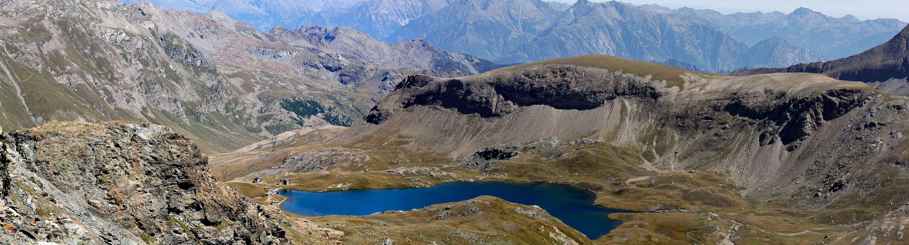
This mountain acts as a divider between the two Vallons of Banchi (Benches; East) and Miserin, lying immediately east of the latter. Topographically it originates from the watershed that falls to the North-northeast from Punta dell'Asgelas (3.021m) to reach the Mont de Dondena (2.548m) just above the eponymous refuge (2.200m). It is easily accessible from all sides, even if the best way is on its side Southwest where a small but easy trail reaches starting from the Lake, Sanctuary of "Notre Dame de la Neige" and Miserin Refuge (2.588m). the complete journey has views towards the top of the Valley of Champorcher, fully highlighting its major Summit which, starting from the East, the Rosa dei Banchi, Bec Costazza, Tour Ponton, Punta Tersiva and frontally Mont Moussaillon with Mont Delà and Mont Glacier, this last the highest of the entire area (3.186m).
Questa montagna funge da divisorio tra i due Valloni dei Banchi (Oriente) e del Miserin, trovandosi immediatamente ad Est di questo ultimo. Topograficamente si origina dallo spartiacque che scende in direzione Nord-nordest dalla Punta dell'Asgelas (3.021 m) fino a raggiungere il Mont de Dondena (2.548 m) appena al di sopra dello omonimo Rifugio (2.200 m). Risulta facilmente raggiungibile da ogni lato, anche se la via migliore si trova sul suo lato Sudoccidentale dove un piccolo ma comodo sentiero lo raggiunge partendo da Lago, Santuario di "Notre Dame de La Neige" e Rifugio del Miserin (2.588 m). la completa traversata offre uno splendido panorama verso la parte superiore della Valle di Champorcher, mettendo in grande evidenza le sue Sommità maggiori quali, partendo da Est, la Rosa dei Banchi, Bec Costazza, Tour Ponton, Punta Tersiva e, frontalmente, Mont Moussaillon con Mont Delà e Mont Glacier, questo ultimo il più elevato dell'intera area (3.186 m).
First Ascent
First on the Summit: Unknown.
In winter: Unknown.
Getting There
BY CAR:
From Torino, Milano, etc: Motorway A5. Exit Pont Saint Martin for then to continue on SS.26 toward Hone Bard.
From Switzerland: through the Grand Saint Bernard Tunnel or the namesake pass. Drive to Aosta, Verrès and Hone Bard..
From France: through Mont Blanc Tunnel or Petit Saint Bernard Pass. It isn't necessary to take Motorway A5: you can drive on SS.26, in the direction of Aosta and Verrès and Hone Bard.
BY PLANE:
Aeroporto "Corrado Gex" Saint Christophe (Aosta).
Specific Road
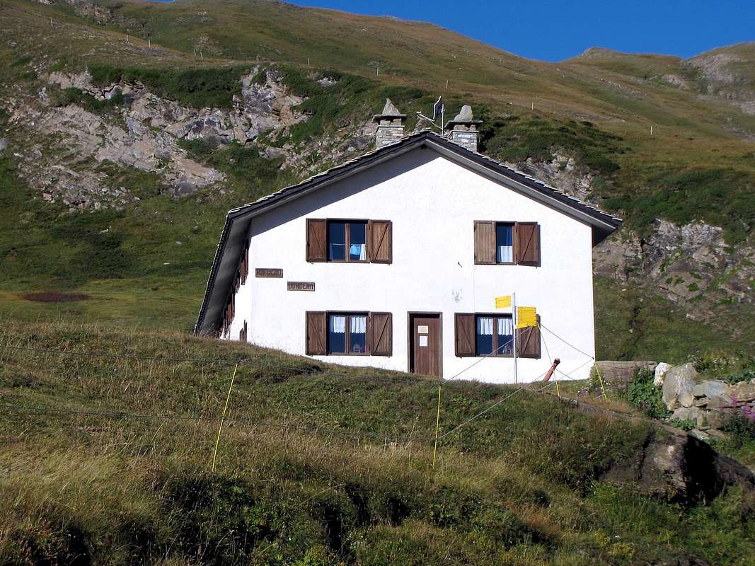
If you take the motorway, exit in Pont San Martin and follow the direction Aosta along the normal route; take care after Donnas: right side, immediately after the village, you can see approx. 100 meters of the roman consular road and a nice arc. A few hundreds meters after the fort there is a bridge left side, over the Dora Baltea River, with the indication Champorcher; follow it. Drive a few km, till the village of Chateau, and look right side for the indication Petit Mont Blanc. Follow this road, not too large, for a lot of km. Part is asphalted, the most part no. Usually the conditions of this second part are good, ask in the area. Follow this road till Dondena Village. At the end a sign forbids the traffic after the parking; there are 3/4 parking area, but the road is steep and demaged. Take care and park in the upper one. When you start walking, you will find a table with the indications, and the map of the area. Come down left till the Torrent Ayasse, pass over the small bridge and along the road shortly time arrive to the Refuge of Dondena (2.097m; 0h'15 from Parking).
Con l'Autostrada Torino-Aosta ed uscita al Casello di Pont Saint Martin; continuare sulla SS. per Aosta (un centinaio di metri dopo il centro di Donnas ed a destra sull'attigua strada consolare romana si può ammirare un bel arco nella roccia); non molto più avanti si incontra il Forte di Bard, famoso per la resistenza effettuata conto l'Armata di Napoleone, e, tramite un ponte sulla Dora Baltea, passare sul lato opposto della medesima in direzione del centro di Hone (cartelli indicatori per la Valle di Champorcher). Percorrere tutta la strada regionale della vallata e, dopo il Comune di Pont Bozet, raggiungere quello di Champorcher in località Chateau. Voltando a destra sulla piazza centrale continuare verso i Villaggi di Mont Blanc e Petit Mont Blanc in stretta strada in asfalto e, successivamente, sulla strada sterrata costituente la ex Strada Reale per Dondena, generalmente in discrete condizioni. Raggiunto il Parcheggio con divieto di proseguimento per i mezzi e con abbondante segnaletica tramite panneaux, cartelli e mappe, scendere brevemente verso il Torrente Ayasse, presso una caratteristica casa contro un roccione. Oltrepassarlo tramite un ponticello e continuando con alcuni tornanti sulla poderale, in breve tempo pervenire al Rifugio di Dondena (2.097 m0h'15 dal Parcheggio).
Approach and Route
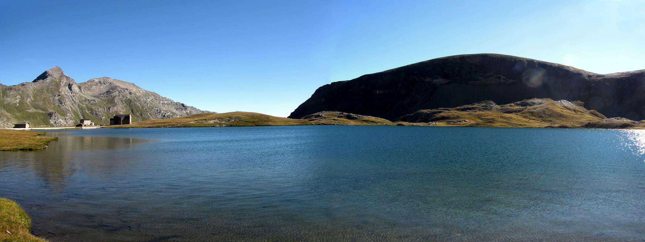
From Dondena Village (2.110m) to come down the small bridge on the Torrent Ayasse, nearby in a characteristic house because built against a great rock, for the old real road and path before signed n° 7B/7C High Route n° 2 and after exclusively through the earth road n° 7B High Route n° 2 to reach the Lake Miserin (2.578m) with Hut and ancient Santuario della Vergine Maria of the Snow (2.582m; 1h'30 from Dondena Village), passing through the Dondena Shelter (2.097m, see above "Specific Road"). From Lake Miserin, Eastern shore, always directed in that direction without following the trail n° 7 to Lac Gelé (2.767m) and the Hills of Balma (West) and Rosa. Instead climb almost directly towards Mount Rascias following a small path that alternates with traces discontinuous and, after a brief band rockier, reach the Summit (E/F; 0h'30/0h'45). From this you can easily walk to the South throughout the watershed, composed of various unimportant altitudes, until you reach the terminal part towards the Lac Gelé. Wanting to complete the round, reaching down towards the Southwest through the same screes and back to Lake Miserin through the route n° 7 that runs through the valley of the same name (EE/F; 1h'30/2h'00 for the whole tour).
Dal Villaggio di Dondena (2.110 m) scendere al piccolo ponte sul Torrente Ayasse, vicino ad una casa caratteristica perché costruita contro una grande roccia, per la vecchia strada reale e sentiero siglato dapprima n° 7B/7C Alta Via n° 2 ed in seguito solamente tramite la strada poderale n° 7B Alta Via n° 2 raggiungere il Lago Miserin (2.578 m) con Rifugio ed antico Santuario della Madonna della Neve (2.582 m; 1h'30 dal Villaggio di Dondena), passando dal Rifugio di Dondena (2.097 m, vedi sopra "Strada Specifica"). Dal Lago Miserin, sponda Orientale, indirizzarsi sempre in quella direzione senza seguire il sentiero n° 7 verso il Lac Gelé (2.767 m) ed i Colli della Balma (Ovest) e della Rosa. Salire invece quasi direttamente verso il Monte Rascias seguendo un sentierucolo che si alterna a delle tracce discontinue e, superata una breve fascia più rocciosa, raggiungere la Sommità (E/F; 0h'30/0h'45). Da questa è possibile percorrere verso Mezzogiorno facilmente tutto lo spartiacque, composto da varie quote, fino a raggiungere la parte terminale sopra il Lac Gelé. Volendo completare il giro, scendere verso Sudovest raggiungendo attraverso pietraie il medesimo e rientrare al Lago Miserin per mezzo del sentiero n° 7 che percorre l'omonimo vallone (EE/F; 1h'30/2h'00 per l'intero tour).
"Guida delle Alpi Occidentali" di Giovanni Bobba e Luigi Vaccarone C.A.I. Sezione di Torino Volume II (parte II), 25 Maggio 1896.
"Guida dei Monti d'Italia–Emilius Rosa dei Banchi Parco del Mont Avic" di Giulio Berutto e Lino Fornelli-Club Alpino Italiano/Touring Club Italiano, Marzo 2005 (in Italian).
"I Rifugi della Valle d'Aosta" di Stefano Ardito, Ed. Guide iter, Febbraio 2003.
"Guida della Regione Autonoma Valle d'Aosta" di Mario Aldrovandi; Ed. S.P.E. di Carlo Fanton, Torino 1964.
"Diari Alpinistici" di Osvaldo Cardellina e Indice Generale accompagnato da Schedario Relazioni Ascensioni 1964-2019 (inediti).
MAPS:
Enrico Editore Ivrea-Aosta "Gruppo del Gran Paradiso" 1:50.000.
I.G.C. Istituto Geografico Centrale Torino "Ivrea Biella e Bassa Valle d’Aosta" (n° 9), 1:50.000.
L'Escursionista "Valle di Cogne Carta dei Sentieri" 1:25.000.
Parents refers to a larger category under which an object falls. For example, theAconcagua mountain page has the 'Aconcagua Group' and the 'Seven Summits' asparents and is a parent itself to many routes, photos, and Trip Reports.

 1831 Hits
 83.69% Score
 17 Votes