
|
|
Route |
|---|---|
|
|
39.35140°N / 106.1108°W |
|
|
Hike/Scramble |
|
|
Half a day |
|
|
Class 2 |
|
|
Approach
Try something a little different! Head south from Breckenridge (or north from Fairplay) on highway 9 to a dirt road on the west side of highway 9, a mile south of Hoosier Pass. Follow the road northwest down to Montgomery Reservoir, and circle to the right of the reservoir until you're at the far west corner - park on the side of the road
Route Description
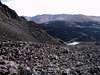
Look up to the western corner of Montgomery Reservoir - that's where you're going. You are at about 10,800'. Climb straight up through the woods, and then angle to the left (South), then curve back to the West and enter the Lincoln Amphitheater - a rocky, broad, passage upward. You enter it at about 11,600' Continue up the amphitheater west, curving to the right until you exit at about 12,800'. Then head WSW straight up to Mt Lincoln - a little less than a mile. Mt Lincoln isn't impressive from this side - just a smooth slope that ends at the top - you don't see the knife edge until you get to the top. From then on you can mix with the other hikers, and the occassional SUV in the Lincoln/Bross saddle. To make it a loop, once you've conquered Bross, descend to the west and link up with the jeep trails heading down the Cameron Amphitheater. You can hike direcly back to the reservoir and around the east side, of bushwhack through the steep, wooded terrain on the west side. Round trip this way is a little less than 7 miles, and about 4,000' of climbing elevation.
 |
 |
 |
Essential Gear
Non technical - just water, good boots, and backup clothes for the unpredictable Colorado mountain weather (summer). No water on this route once you leave Montgomery reservoir.
Miscellaneous Info
If you have information about this route that doesn't pertain to any of the other sections, please add it here.