

|
|
Mountain/Rock |
|---|---|
|
|
39.28957°S / 175.56256°E |
|
|
Hiking, Mountaineering, Trad Climbing, Toprope, Ice Climbing, Mixed, Scrambling, Skiing |
|
|
Spring, Summer, Fall, Winter |
|
|
9177 ft / 2797 m |
|
|
Overview
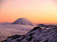
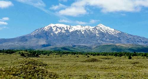
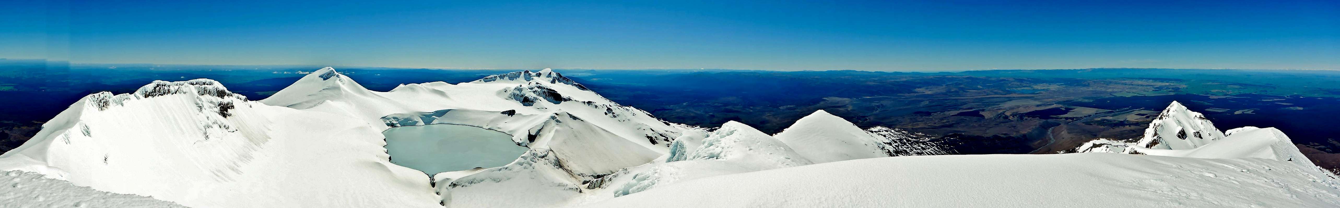
Mount Ruapehu is the highest volcano on the north island of New Zealand. Its volcanic status is currently active and the most recent major eruption were between 1995 and 1996 with additional activity in 2007. A lake currently sits over the vent, changing in nature and hazard level with mood of the volcano. Along with Ruapehu there are two other active volcanoes in the Tongariro National Park, they are Tongariro and Ngauruhoe. They form part of the extensive Taupo Volcanic Zone which runs up to White Island and beyond.
Ruapehu has wide mixture of climbing and tramping challenges and can be visited all year round. From round the mountain tracks to ice climbing there's something for everyone. Accessing the crater and the lake within is achievable for most people via one of several routes with the highest of the many peaks on the rim, Tahurangi, a more technical challenge. The journey up and views from the top are quite breath taking, including views all the way to Mount Taranaki/Egmont on the west coast.
Despite the volcanic hazard, Ruapehu has three ski fields, Turoa, Whakapapa and Tukino that typically operate from June to October and are the prime destination for this activity in the North Island. The infrastructure developed for the ski industry has also made exploring other opportunities on the mountain more accessible and form the main access points for tramping and climbing also. This wide ranging popularity and focus has led Ruapehu to often being just referred to conversationally as "The Mountain".
The Department of Conservation (DOC) website has excellent resources covering most areas of interest.
 Ngauruhoe Ngauruhoe |
 Whakapapa side Whakapapa side |
 Crater Lake Crater Lake |
 Turoa side Turoa side |
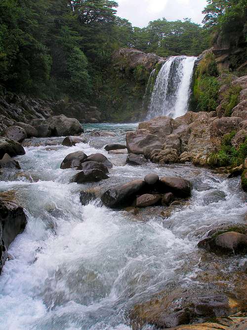 Tawhai Falls Tawhai Falls |
Getting There
|
View Larger Map (if no image above, right-click area and refresh) |
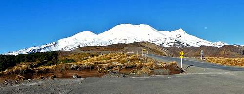
Tongariro National park is located in the middle of the North Island. It has a road circling it with State Highway 1 to the East which runs from Auckland to Wellington via Hamilton, Taupo and Palmerston North and State Highway 4 to the west which runs from around Tu Kuiti to Whanganui. There are also flights to Taupo or other regional centres as well as some train stations around the area. As mentioned above there are two main access points to the mountain due to where the ski fields are, Whakapapa to the north and Turoa to the south. The main local centres to these are perhaps the imaginatively named National Park, close to Whakapapa and Ohakune, close to Turoa. There is additional infrastructure at Whakapapa itself (Iwikau Villiage) but nothing closer to Turoa except for the ski base. There are also plenty of other regional hubs. Car rental costs in New Zealand are generally affordable and this is the easiest way to get to trail heads. From Taupo it is 100 km to get to National Park (a 1.25 hour drive), from Auckland a 324 km drive (4 hours) and from Wellington a 313 km drive (4 hours). The maximum speed limit in New Zealand is 100 km/hr (62 mph) with lots of single lane roads and trucks to sit behind so expect things to take longer that you might initially think as does driving around the park's perimeter. Road access in winter may be more challenging depending on road conditions when some may be temporarily closed or chains required. There's also an army firing range on the east side of the park. |
When to Climb and Red Tape
The mountain can be visited year round depending on interests, experience and road access/conditions. Due to the southern hemisphere location December through February are the warmest months and June through August the coldest. There will usually be at least some snow on the top of the mountain year round, with the least in perhaps March/April.
There's a lot of easily accessible avalanche information available for the park (during winter) as well as weather forecast information. You can also call the ski centres to get updates from the ski patrollers. Mobile phone coverage on the mountain exists.
There are no particular restrictions when visiting the mountain for your average visitor. The general ethos is New Zealand's national parks is that you're responsible for your own safety. While search and rescue teams do exist along with availability of various comms equipment it's not something to rely on per se, i.e. don't get into a bad situation on purpose. Check with the local DOC if in doubt/with any questions.
However this will vary if there is heightened volcanic activity at Ruapehu. The impacts may be keeping a particular distance from the crater lake to staying off the mountain entirely. Check before you go with GNS and the DOC. Also see the Volcanic Hazards and Activity section below.
Routes
Ruapehu is a big mountain with an infinite number of things to do and ways to go and pointy things to head up. Listed below are a few examples including the most common (easiest) routes. Additional information particularly on more complex routes and to other parts of the mountain can be found in the Resources section below. There doesn't seem to be much in the way of easily found information on technical routes specifically in summer unfortunately beyond references to "lovely/blocky scrambling" though there are a few potentially useful photos around on different blogs, there are some assorted links for those in Resources also. While the DOC does provide route information on summiting Tongariro and Ngauruhoe, their information on Ruapehu is limited to the easiest route to the crater and lake view, not the high point/true summit, Tahurangi, which is a technical route any time of year.
Crater rim peaks:
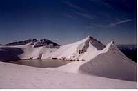
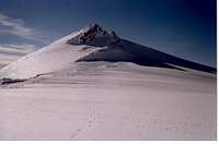
In addition to the high point Tahurangi (2797 m), there are a number of other prominent peaks at the top of Ruapehu, each with a large number of their own routes. Several may be taken in during a traverse of the mountain or as a crater circumnavigation for example. See the Resources section below for further information. These peaks include:
|
|


Whakapapa (north) side:
There are a couple of places to start these routes, e.g. Iwikau Villiage (1600 m) or The Knoll Ridge Cafe (2020 m) depending.
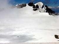
Crater access / Dome Shelter (2672 m) - Possibly the most common route for your average visitor as it's the most with the most documented information, including by the DOC. Between Iwikau Villiage and The Knoll Ridge Cafe there's the Waterfall Express chair lift that runs a lot of the year but if it's windy it won't be so anticipate having to hike on trails an extra 90 mins between the two. The DOC suggests two options beyond here depending on the time of year, Knoll Ridge better for when there's still snow about and Restful Ridge for when there's less (see links below for more details). They both have the same trajectory heading almost directly south up towards the rim. As there's not really a set route or markers it can be a bit disorientating either going up or down so be aware of what you're doing, a GPS track is useful for when you're in a cloud and can't see anything. You'll likely come across a view of the Summit Plateau first. Keep that to your left and follow the ridge round to the Dome Shelter and view of the Crater Lake. The big dome shaped peak you'll see on your right across a glacier is Paretetaitonga (2751 m) and not your primary objective. Before going beyond this point check the volcanic hazard level. Officially 5-7 hours / 7-10 km return. Consider that these kinds of values would perhaps require high fitness, little snow and not carrying much. See these links for more info: DOC crater climb guide and Additional DOC crater climb info |
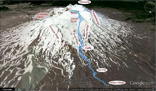 Dome Route map Dome Route map |
 Iwikau Village Iwikau Village |
 Top of Knoll Ridge Top of Knoll Ridge |
 Decisions Decisions |
 Summit Plateau Summit Plateau |
 Crater Lake Crater Lake |
Crater traverse / Tahurangi (2797 m) - ONLY IF NO VOLCANIC HAZARD WARNINGS! Continue past the Dome Shelter and skirt round the west side of the lake (be careful re. hidden crevasses) before heading up to the Summit Col between Te Ataahu and Tahurangi (north facing, snow may be very soft). Then depending on the season judge the best way of heading up to the summit by either heading straight up the West Ridge (steep with or without ice, NZ alpine grade 1+ or 2, class 4-5 scrambling ?, useful photo here) or heading SE and across to Skyline Ridge and up on to it where possible. Looks to be roughly 2 km to cover from the Dome to the summit, and 2 km back again. Ease of this will vary with the time of year as it can be cliff like at points but is generally rated as NZ alpine grade 1, i.e. you probably don't need a rope in winter unless there's a glacier/crevasse risk which there may be, see above but again may be a steep scramble if there's no snow.
 |
 |
Turoa (south) side:
There are several places to start these route, e.g. Blyth Hut (1380 m), the Turoa ski field parking lot (1623 m) or the top of the highest ski lift (2,322 m) depending on time/weather/inclination. You can get a special Mountaineering Pass from the ski centre for NZ$30 or so if you want to ride the lifts and skip some ascent/descent.
Crater access / Summit Col (2730 m) - Head up past the ski infrastructure and continue up the snow/ice ("Gliding Gladys"), curving north as you get higher till you hit the rim between Te Ataahua on your left and Tahurangi on your right. In winter it's a very open run out with nothing to hit. South facing so ice may be hard till after the sun's been up for a while. Usually plenty of snowboarders heading up in the afternoons, sometimes also falling unexpectedly as it's pretty steep. From the col you can climb down into the crater but be aware of the potentially soft north facing snow and an easy fall into the crater lake in addition to any VOLCANIC HAZARD WARNINGS! Maybe 1.25-1.5 hours from the top of the ski lifts. Skyline Ridge / Tahurangi (2797 m) - The most reliable way of doing this is by heading up Skyline Ridge which runs along the right of the ski field up to the top. It's graded as NZ alpine grade 1, i.e. you probably don't need a rope unless there's a glacier which there isn't really, at least on the ridge. The route gets increasingly steep, up to maybe 40 or 45 degrees before you reach the height of the rim and the ridge flattens out significantly. Then it's a relatively short and easy if bit airy walk along the ridge top to the summit. Quite how the route will be shaped and experienced will depend on the weather patterns and snow/ice level and firmness. The route doesn't feel overly exposed though there are some rocks to crash into if you don't self arrest during a fall though. Takes about 1.25-1.5 hours from the top of the ski lifts. Alternately you can head up to the Summit Col (mentioned above) and then as also mentioned on the Crater Traverse section, trying the West Ridge or traversing around to Skyline. |
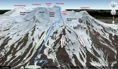 Ruapehu - Skyline Ridge route map |
 Heading on up Heading on up |
 Runout Runout |
 Getting there Getting there |
 Last bit Last bit |
 Return route Return route |
Volcanic Activity and Hazards
While there have been large magmatic eruptions at Ruapehu from time to time, one of the most common hazards is the water in the crater lake. On a number of occasions the lake has filled behind tephra dams which have eventually collapsed allowing the lake to drain catastrophically as lahars. Hydrothermal or phreatomagmatic eruptions have also produced the same effect. While on the mountain these are probably what you want to be most aware of the risk of aside from the usual climbing related ones.
A selection of recent events:
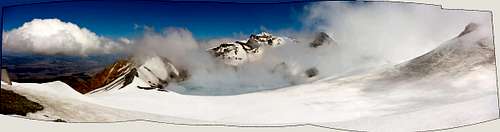
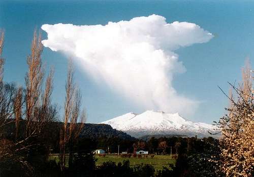 Plumes or clouds?
1953: A massive lahar went crashing down the Whangaehu River with no warning following the failure of a tephra dam holding back the crater lake. This dam had formed during the prior 1945 eruption. Sometime around 10:15 p.m., the lahar which was filled with ice, boulders and tonnes of water crashed into the weak old concrete pylons of the Tangiwai rail bridge, significantly weakening it just as a train was coming. A young man named Arthur Cyril Ellis tried to warn the driver by waving a torch at the train. The train applied its breaks but not nearly soon enough and the train's weight caused the bridge to collapse. 151 people were killed.Source
1995-1996: The most significant activity since at least 1945. Following almost a year of precursory activity, explosive activity occurred in August-October 1995 and repeated to a lesser extent in June-August1996. Large dramatic plumes were formed which spread to other parts of the North Island, impacting farming, air travel and hydroelectric plants. Lahars also occurred in different parts of the mountain. This activity led to further development of lahar and dam monitoring systems which had begun after the events of 1953. Source
2007: Earlier in the year a lahar formed as a result of a tephra dam collapse, the dam being generated by material from the 1995/1996 eruption sequence. Six months later a short duration explosive eruption occurred which deposited tephra around the summit region and generated lahars on the Whakapapa side. Damage was caused to the Dome shelter, injuring an occupant in the process. Source
Recently: In the years since and as recently as early 2015 there were some fluctuations in the crater lake temperature with the alert level currently set at 1 (signs of volcanic unrest). Source
Also see:
- GeoNet alerts/status/records/webcam,
- GeoNet bulletins and hazard maps
- Global Volcanism Program reports
- GNS documentation of Ruapehu's history
Camping and Other Accommodation
There are multiple camping opportunities in the area, either provided by the Department of Conservation or private entities. Some suggestions are listed below:
Whakapapa (north) side:
Mangahuia (DOC)
Discovery Lodge
Turoa/Ohakune (south) side:
Mangawhereo (DOC)
Contact the local DOC about camping outside of designated campsites. Camping in the crater is discouraged and is also hazardous from a volcanic point of view.
Accommodation options can also be fancier, for example on the Whakapapa side at the base of the mountain there is a well known and distinctive hotel called the Grand Château. This place has many features including tennis, a nine hole golf course, a cinema, heated pools and a gym.
In addition there are several huts on the mountain which are either run by the DOC for tramping purposes (there a Round the Mountain track) or run by clubs of the climbing or snow sports variety. You may be able to stay in them by contacting the relevant organisations.
Further Resources
Maps:
- "Tongariro - Parkmap 273-04" (1:80,000) by The Department of Conservation. (Huge map)
- "Ruapehu - Round the Mountain Track, Tongariro National Park" (1:60,000) by NewTopo. (Pretty small map)
- Whakapapa and Turoa ski area maps by http://www.mtruapehu.com/, also available at ski fields. (Good for side perspectives)
- Online topomaps: http://www.topomap.co.nz/NZTopoMap/nz49955/Mount-Ruapehu/ by NZ Topo Map.
Books:
- "Tongariro - a guide for climbers and ski-mountaineers" by Richard Thomson, a New Zealand Alpine Club publication. (Invaluable, your new best friend)
Websites:
- Ruapehu routes guide (Derived from the Richard Thomson book though route grades may not be entirely accurate/in line with it)
- Ruapehu climbing album
- Skyline Ridge photos amongst others
- L Peak and Pyramid Peak deets
Assorted links on summer/snow free conditions:
- http://www.lukefoster.com/2012/to-the-top-of-mount-ruapehu/
- http://www.flickriver.com/photos/tags/mangaturuturu/interesting/
- http://tramper.nz/?view=topic&id=116
Gear shopping/rental:
There are plenty of outdoor shops in New Zealand as you might expect with different customer type focuses. In my experience Kathmandu usually have the least technical stuff, followed by Macpac, with Bivouac and Living Simply (Auckland) more likely to have climbing related things and the staff experience to go with it.
atavist - Apr 16, 2012 2:02 am - Hasn't voted
Allow 3+ more hours to tag the 'summit' (as of 2012)"As for climbing the mountain the most common and simple ways of climbing it are simply walking up past the two ski feilds. Not a hard mountain to climb." Most visitors ride the skilift, then make the short hike up to the crater rim or the shelter overlooking the crater lake. For serious climbers the volcano has much more to offer. The true summit can be accessed by crossing a glacier sitting on a very active volcanic rift. The slide zone of the glacier ends in a 20 meter plunge into a glacier lake. Finally, the true summit can only be accessed via a full pitch of 4th class to easy 5th class rock climbing. There are other interesting peaks and spires scattered about the upper reaches of the volcano as well.
Baarb - Oct 30, 2015 9:39 pm - Hasn't voted
Re: Allow 3+ more hours to tag the 'summit' (as of 2012)Hi there, I've recently updated the page some. It would be useful to know a bit more about more specifically where the 4-5th class scrambling is, say the West Ridge for example? The Crater Face route initially looks like it would be higher rated than that though you also mention in you log that you down climbed that. Thanks.