
|
|
Route |
|---|---|
|
|
35.76484°N / 82.26512°W |
|
|
Hiking |
|
|
Spring, Summer, Fall, Winter |
|
|
Short, moderate, hike with strenuous sections. |
|
|
Overview
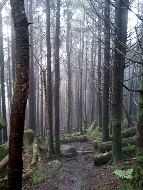
The Old Mitchell Trail was the primary trail for reaching Mount Mitchell during the late 1800s and the early 1900s. This trail originated along the North Fork of the Swannanoa River some 12 miles (as the crow flies) from the summit of Mount Mitchell. Nowadays this trail is typically hiked 2.1 miles from the Mt. Mitchel State Park office, or 1.8 miles from the restaurant parking lot, to the summit. Deer are often seen along this somewhat strenuous trail.
Getting There
From the Blue Ridge parkway follow highway 128 to the park headquarter, or another 1/2 mile to the restaurant.
Route Description
If parking is limited start the hike at the south end of the restaurant parking lot. Alternatively, start less than 0.5 miles lower at the park headquarters, and hike to the restaurant.
From the restaurant parking lot the trail leads uphill behind a map and sign board, and soon passes the employee barracks. Next the trail continues uphill through an open area with some good views, back toward the restaurant, of the surrounding mountains. As the trail crosses over the crest of the main ridge to the left is a green water tank. Shortly past the water tank it approaches the park road, and then drops off the ridge. As the trail loses and re-gains elevation several sets of log and rock steps will be encountered prior to the trail heading unquestionably downhill for a one hundred or more vertical feet. Much of the trail is rocky and can be slippery. Soon more sets of wood and rock stairs, and even a bridge, are encountered as it approaches a spur trail off the right which leads to the old logging camp known as Camp Alice.
Following the intersection of the Camp Alice trail, the Old Mitchell trail enters a dense stand of fir trees, and at times is very rocky. Highway 128, to the summit, is close by. Soon the trail tees into the main 1/4 mile paved trail originating from the summit parking lot. Turn right and follow the paved path uphill an 1/8 of a mile to the observation platform on the summit. A left, instead of the right takes one down, also an 1/8 of a mile, to the summit parking lot with its concession area, museum, restrooms, and picnic area.
The total one-way hiking distance from the restaurant parking lot located at about 6,100 vertical feet to the 6,684 foot summit of Mt. Mitchell is 1.8 miles.
The reverse of the trail can be followed to return to one's car. It is also possible to return via Camp Alice to the park headquarters.
Essential Gear
Comfortable boots, and some water. Depending on the weather, perhaps an insulating jacket and a rain coat.
External Links
Map: https://files.nc.gov/ncparks/maps-and-brochures/mount_mitchell_park_map.pdf
About the Author
As of 2019 the author has visited Mt. Mitchell twice. The first time was in May 2001 when he and two friends drove to the top of North Carolina’s Mount Mitchell. The second time was in October 2019 as part of a solo US State highpointing trip known as the Southern Six Pack. In 2019 he hiked to the summit and also camped, in the rain and wind, at the awesome nine-site tent-camping campground located about 6/10 of a mile below the summit.
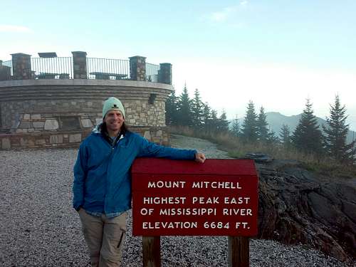 October 2019 - The Author at the Summit of Mt. Mitchell