Introduction
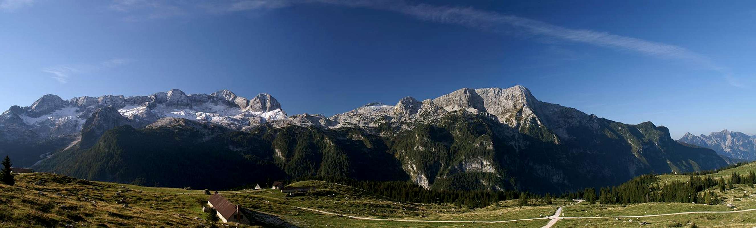
![Looking across the altopiano from the summit of Monte Sart]() Julian Alps seen from Monte Sart Julian Alps seen from Monte Sart |
The border region between Austria, Italy and Slovenia bears witness to a tumultuous history. Three ethnic groups, Slovenians, Italians, Austrians have made the area their home and for most of the time lived in harmony with each other. The sharp ridges of the Julian Alps separated the groups at first but over time people migrated across the passes to set up home “on the other side” so that even today villages, towns and mountains often carry three names. In the late 19th and early 20th centuries however, the concept of nationality, later nationalism put an end to peace and understanding. On May 23rd the Italian ambassador to Vienna handed over the declaration of war to the Austrian foreign minister, with which started the war in the mountains, Gebirgskrieg in German, which raged for four years across the mountain ranges along the Italian-Austrian border. The fiercest fighting occurred along the river Isonzo, Soča in Slovenian, a river which runs from its source in the Julian Alps to the Adriatic sea, less than 100km to the south. In its northern part this front climbed over the ridges of the Krn, Kanin and Vis/Montaz Groups which were fortified with dugouts, trenches and artillery positions.
Today most of the former war zone lies on Italian terrain. What remains are the ruins of forts and dugouts, often even now still decorated with pieces of barbed wire or empty shells. There are wartime cemeteries commemorating the Austrian and Italian soldiers who died here, often by cold and starvation rather than by the fighting itself. What also remains is a network of wartime trails, reaching up to the wild summits of the range, but also heading across the valleys and high plateaus of the range. They emphasise the incredible effort it took to get all the war materiel in place but also bear witness to dramatically improved relations between countries and people. Today a diverse crowd hikes and climbs along these wartime trails and the only sign about any difference among them is that everybody prefers to call the names of the mountains in their own language.
Ski Runs, Caterpillars And A Hole Issuing Cold Air
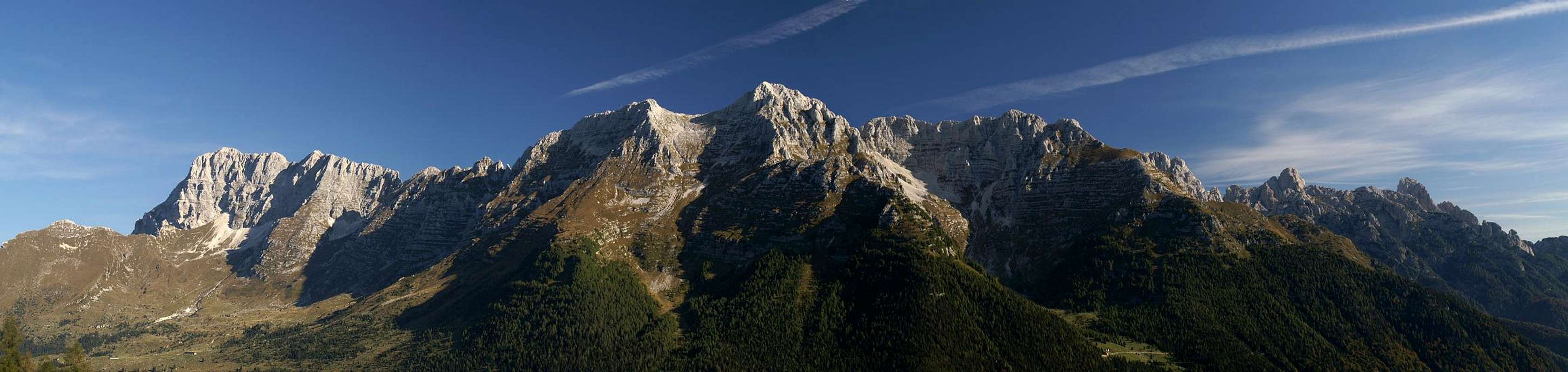
The picture shows the route from the ski runs in left bottom to Monte Sart to the far right |
For days Judith has been suggesting a hike in the north of the Kanin Group – from Sella Nevea to the eastern Altopiano, cross it to Rifugio Gilberti and back to Sella Nevea again. They say it is a beautiful hike in spring because of all the flowers but now it is the second half of September and all the beauty will have withered away. Also, I never ceased to point out that the snow which fell three days ago was bound to linger longer beneath the north faces of the Kanin Group than on any south face route, which redirected us elsewhere. Yesterday elsewhere was Cima di Terrarossa just across the saddle to the north of Sella Nevea and it was obvious that the snow had disappeared almost everywhere on the Altopiano. Consequently last night the discussion resurfaced again and all I could do was to suggest the western part of the Altopiano and a climb to Monte Sart, the westernmost mountain of the Kanin Group.
Monte Sard, Zrd in Slovenian, had featured in our discussions a week before. The last of the cable-cars was supposed to go up at that time to be closed for the remainder of autumn. Our climb should have been right after the
SP gathering on Dovski Kriz but Judith’s accident during that trip had forced us to abandon it. Now, without the cable-car it will be much tougher – 1800m elevation gain and some 18km to go with it – but we’ll both get what we want – a win/win situation.
The huge parking lot at the cable-car station is empty as we arrive. We abandon any hopes that the season might have been prolonged for a weekend. A last check on our map confirms that the shortest way is along a dirt road which basically follows a ski run. Certainly it will be ugly. But then it will bring us up to the Altopiano real fast. Ugliness greets us right behind the cable car building. Caterpillars are standing around, obviously parked there to work on the lowest part of the run. We’re glad that today is Sunday. Maybe even lucky – it looks like the road is closed on weekdays and there certainly is nothing more disconcerting than to hear the drone of these big machines. We’ve been through this near Cortina d’Ampezzo, also near Passo Tonale – in both cases ski runs had been expanded. Not today!
We walk between the machines, or rather – we scramble. Big grooves run through the ground and we climb in and out of them to reach the dirt road. It turns out, however, that the dirt road does not exist. There are tracks here and there but mainly we will have to follow the ski run directly. And as ski runs go – it is a very steep one. I remark on us being even quicker to reach the Altopiano but the lack of an answer proves to me what Judith thinks of this. Oh well!
The climb is steep – very steep and in some places even steeper than that. Every now and then we glimpse a view of the neighbouring Viz/Montaz Group but most of the times we see trees, poles and snow guns. We overtake a trio of Italians after a third of the way, then a second ski run joins from the top. A sign “Rif. Gilberti” shows which is the right one and we head up the one to the left. Though we have been climbing less than an hour our feet and legs are already tired and hurting. After the next bend in the ski run we realize that we are already close to the Rifugio. Above us the run heads straight for the upper cable-car station, a 1500m straight line which looks even less promising than the curving switchbacks underneath.
The Vis / Montaz Group seen from the ski runs of Sella Nevea |
Luckily for us a sign directs us to a narrow path which avoids the ski run and rather heads for the base of the giant east face of Bila Peč. We soon arrive there only to notice that the snow of four days ago is melting on the mountain producing a constant dripping trickle from above. The Bila Peč east face is slightly overhanging and our path leads us underneath these overhangs. We try to avoid the water - but to no avail. The path leads on directly underneath. Suddenly a second path turns off right, right to the wall. A sign indicates that this is the right path and we pass behind the sheet of dripping water.
Suddenly Judith stops and points at a hole in the ground – “There’s air coming out of it!” I join her and indeed – a jet of icy air hits my face as I lean over the hole. We had been told that there are a lot of caves underneath the Altopiano, a veritable karst landscape. We had been told the same on Crete or on Sardinia but nowhere had we witnessed an effect like this. Somewhere underneath us a large cave must receive lots of air through other openings. The whole over which we are leaning is probably like chimney channeling all the air out again.
Rifugio appears in our field of vision and our path turns into a “botanical trail”. Lots of signs in three languages tell us which plants grow here – but in September most of the plants are already invisible. There are some withered blossoms but in general I feel justified to have redirected Judith from the eastern part of the plateau. Here we’ll have the goal of climbing a summit, after all.
Sella Bila Peč
Rifugio Gilberti turns out to be a beautiful small builing, probably dating back to the 1920’s or 1930’s. It has a sort of veranda and rounded windows – a nice little building indeed. Obviously it is too small to accommodate hikers and skiers in the 21st century. Right beside it a huge concrete something is being built. The first floor is already finished – a crane hovers above it and other big machinery is parked around it. Again we’re glad that it is Sunday. But somehow the whole situation makes me sad.
![The slightly overhanging east face of Bila Peč]() Bila Pec East Face Bila Pec East Face | ![Bila Peč]() Bila Pec Bila Pec | ![Karst skeletons]() Karst Formations Karst Formations |
We turn westward and try to find our further route. Above us there is still the Bila Pec east face but now the less intimidating southern one opens up before us as well. To its south, west of our current location is the saddle Sella Bila Peč, which separates the mountain from Srednij Vrsic on the Kanin Crest. The karst-like nature of the Altopiano becomes evident right at our feet. Crevices cut through the limestone rock, giving a skeleton-like impression. Our route reads into a large doline, another proof that we are on karst. Here an underground cave must have collapsed, creating this huge funnel.
We head down and across the doline, then up towards the saddle, which we reach after 30 minutes. I contemplate climbing Bila Peč for a moment but then delay it until the time we will return here in the afternoon. Probably it won’t happen anyway. On Sella Bila Peč there is a WW I fort – or what remains of it after some odd 100 years. The walls are standing but there is no roof and the windows naturally have vanished long ago. Looking inside I can see the place where the latrine used to be but apart from that nothing is left. I shoot a few pictures from the saddle with one looking through a window through the fort at the summit of Bila Peč.
![Bila Peč]() Bila Peč seen throgh the WW I fort
Bila Peč seen throgh the WW I fortThe “Plateau”
![Karst!]() The Altopiano
The Altopiano
Altopiano means “high plain” and when you look at one from afar you’re tempted to expect a plane surface. Years of karst experience have taught me, however, that a plateau on limestone rock will be the exact opposite. Lots of crevices cut through the surface, caves have given way to form dolines and above all hover summits which had looked like hills from the other side of the valley. Here, on the altopiano of the Kanin Group this experience is confirmed, even emphasized. From Sella Bila Peč the altopiano looks like a veritable stone desert, very hard to traverse without a path to guide you. We had the experience of getting lost on the Altopiano delle Pale di San Martino when descending from Cima della Fradusta. Even in perfect weather the goal you’re aiming for is more often hidden than revealed and back in 2005 we only reached our cable-car in time because I had the track on my GPS showed where we had started. After many a deviation we finally managed to return in time, though barely and at running speed.
![Modeon del Buinz]() Modeon del Buinz Modeon del Buinz | ![Picco di Carnizza]() Picco di Carnizza Picco di Carnizza | ![Bila Peč]() Bila Peč Bila Peč | ![Vis / Jôf Fuart]() Vis / Jôf Fuart Vis / Jôf Fuart |
Today the task is much easier, thanks to the soldiers, who in WW I created a mulateria, a mule trail from Sella Bila Peč to Forcella di Terra Rossa, just beneath the east summit of Monte Sart. The trail heads along the upper outside of the altopiano, often running along ledges, especially near Sella Bila Peč. There is not much snow left but in several places it persists sometimes having transformed into solid ice. The ledges are sloping sometimes and though a fall would not be fatal it would certainly hurt much. We keep as close to the mountain as possible and carefully negotiate the verglassed sections. The sun is rising higher now, but here in the shadows of the Kanin Group north faces we’re still freezing. Every now and then we head out of the shadows and the sunrays heat us up immediately but then it’s back to the cold of the shadows again.
![Picco di Grubia (2240m), Monte Sart (2324m), Col Sclaf (2157m)]() The Altopiano The Altopiano | ![WW I war trail]() Warpath Warpath | ![Picco di Carnizza]() Picco di Carnizza Picco di Carnizza |
Finally the path drops away from the faces and into a large doline. Again karst formations greet us. Views towards Monte Sart and Col Sclaf to its north-east are perfect and so is the backwards view to Bila Peč. The Viz/Montaz group however, hides behind a thin layer of mist. Apparently it is a day for close-up views. The next stage leads to Sella di Grubia with its tin box of a bivouac, Biv. Marussich. From here you can perfectly take in the views of the Altopiano above which the big mountains of the Julian Alps rise – Jalovec, Mangart, Skrlatica, Triglav.
![Picco di Grubia]() Picco di Grubia Picco di Grubia | ![Bila Peč]() Bila Peč Bila Peč | ![Picco di Grubia (2240m), Monte Sart (2324m)]() Picco di Grubia, Monte Sart Picco di Grubia, Monte Sart |
Again I contemplate climbing another mountain, Picco di Grubia. As to my knowledge it is not yet on SP, so why not? It is a trail-less scramble of some 200m to the summit but again I postpone it until afterwards. Instead we hike along underneath its northface to reach Forcella di Terra Rossa. A dog barks on Picco di Grubia’s summit, then two men start descending towards us. We pass underneath them until suddenly the path is closed. A cave has given way and the ground beneath the trail has collapsed on a length of 30m. We follow the detour, descending to the right of the blocked passage. When we reach the collapsed section we can look deep into the heart of the mountain. Though it looks like being 20m deep only I have the feeling that underneath a huge cave is waiting for exploration. Another dog, another man head towards us – “Bon Giorno” – and they vanish in the direction of the hole in the ground. We climb to Forcella di Terra Rossa above which the twin summits of Monte Sart rise.
Monte Sart
![Monte Sart]() Monte Sart
Monte Sart
Monte Sart is a broad stretched mountain, culminating in two summits of almost equal height. The eastern summit under which we are standing is 5m lower than the broader main summit in the west (2324m). The best ascent route from Forcella di Terrarossa follows the east ridge across the east summit towards the main one. The south face is a steep grass slope while the north face is an almost vertical rock face. From the Forcella it is immediately obvious that the climb will be exposed, that there will be no protections anywhere, probably not even the possibility to place protections. But only 200m are missing now so we set out to find the entry point to the ridge traverse.
![On the east ridge]() Ascending the east ridge of Monte Sart
Ascending the east ridge of Monte Sart
A narrow path leads away from the ridge, then crosses the south slopes of Monte Sart. According to the guidebook this should be the return route. Another, even narrower path turns off from it and – after having avoided a vertical section heads back north to attain the east ridge. We follow it and suddenly become aware of marks on the rocks, an arrow here and there, to show the way. Up we go. There are a few sections where we get very close to the abysimal north face, then back off again and climb a short class II section, back to the ridge again and so forth. Views become better and our hearts are pounding, partly because of the views, partly because of the efforts, partly because of the exposure. Finally we reach the east summit, 2319m. A narrow ridge connects it with the main summit 500m further west. Since it’s already 1 p.m. we decide to have lunch, then look at each other and decide to forgo the main summit. We still have a long way to return and 5m surely won’t offer better views.
360° summit panorama Monte Sart |
The views indeed are great. We are on one of the westernmost mountains of the Julian Alps and the range stretches out to the east and north of us. To the south a glimpse of the Adriatic Sea can be seen and to the west the huge range of te Carnic Alps stretches towards the Dolomites. It is still a bit hazy in that direction so that the Sexten and Cortina Dolomites can only be guessed. Far in the north the glaciated summits of the Hohe Tauern Range glisten in the sunlight. We goof around a bit with self timed summit shots and discuss the summits which are in view. The sun is shining, finally it is warm and we don’t feel like heading all the way back already.
But a cloud brings us back to reality – suddenly it’s dark and cold and even if we are fast we will be in Sella Nevea around 6 p.m. only. Packing our things we sigh and get going again.
Return Journey
![Dream-like colours during descent]() Descending Monte Sart
Descending Monte Sart
We decide to take the ascent route and not to search for the unmarked path the guidebook writes about, at least we can’t go wrong there. With the Julian Alps at our feet the ridge traverse is incredibly beautiful. We have to take care of course but every now and then we stop and take a look. As usual descending appears to be much easier than ascending and though there still are some tricky sections we get down to Forcellla di Terra Rossa quite easily. The light has changed dramatically in the last hour and now the whole setting has become a photographer’s dream. Deep blue skies alternate with green meadows and contrast beautifully with the nearly white limestone. Anywhere we look the scenery is simply beautiful.
![Monte Sart main summit]() Monte Sart Main Summit Monte Sart Main Summit | ![Monte Sart, Monte Cimone]() Monte Sart, Monte Cimone Monte Sart, Monte Cimone | ![Col Sclaf]() Col Sclaf Col Sclaf | ![East ridge descent]() Descending in front of Kanin Descending in front of Kanin |
We pass the collapsed cave and return to Sella di Grubia with Picco di Carnizza towering above us. We take a look at the Bivacco but there is no question about climbing Picco di Grubia anymore. SP will have to wait for it and certainly it can be missed. We head out on the Altipiano and now colours become surreal. A bluish tint lies across everything,, the karst structures being emphasized by this kind of light. We hurry along and reach the ledges before Sella Bila Peč. A view back reveals that the Monte Sart north face is in deep shadows already and we have to hurry in order not to be overtaken by dark. Monte Cimone which had been hidden by haze now comes to live and shines across the Altopiano.
![Bila Pec (2146m) in front of Hudi Vrsic (2344m) and Lopa (2406m)]() Bila Peč, Hudi Vrsic, Lopa Bila Peč, Hudi Vrsic, Lopa | ![Monte Cimone]() Monte Cimone Monte Cimone | ![Say goodbye to the Altopiano]() Final View of the Altopiano Final View of the Altopiano |
Finally we reach the saddle and decide to take a break before the final descent along the ski runs. Two Italians also stay there bathing in the sun and having some sort of improvised lunch. I explore the fort once more, then look north and east and shoot some last photos of the surrounding mountains. Beneath us the construction site alongside Rifugio Gilberti can be seen but I decide to take a picture anyway. If all fails I can photoshop it off the frame.
![Looking from Sella Bila Pec to Rifugio Gilberti]() Looking from Sella Bila Peč down to Rifugio Gilberti
Looking from Sella Bila Peč down to Rifugio Gilberti
With another sigh we make ready for the descent, this time using a branch of the botanical hiking trail to cut short a part of the route. This way we won’t get close to the rifugio but we have been there in the morning and it is closed anyway. The signs for the flowers tell us that in spring this must be paradise but currently there is no flower left. Trning northward we head for the giant Bila Peč east face, visit the hole in the ground (still jets of icy air are issuing from it) and stumble towards the ski run.
![Lopa (2406m)]() Lopa Lopa | ![Prestreljenik (2499m)]() Prestrejenik Prestrejenik |
What follows is nightmarish. The slopes are so steep that you can’t walk quickly. Scree covers everything and many a time I almost fall. Judith with her accident to remind her of what a fall can feel like is even more careful and it takes forever to get down. We try to avoid the scree covered ski runs and hike the overgrown parts beside it but many a ditch forces us back onto the ski run proper. After each turn I hope it will be the last but there’s always another one lurking behind the next corner. Knees start to hurt, elbows too – how many of these turns are left? Finally we meet people who come up from Sella Nevea and since it already late in the day we know we can’t be far now. A last turn and here is the parking lot with the cable-car station. Finally! Just make sure not to fall on the last few metres. The lot is full of Sunday tourists who crowd in and out of the cable-car restaurant and the accompanying kiosk. We retreat from the crowds, get in the car and take flight. The car is full and it will take an hour to get back to our apartment in Kranjska Gora.


Comments
Post a Comment