I must admit that I knew next to nothing about Oregon’s Mt. Hood. I must have seen it when traveling down I-84 years ago but its image was not in my mind, I did not know anyone who had climbed it, and I’m not even sure I knew that it was the highest point in Oregon! Yet I wanted to climb it, and since we were going to be in the general area I put the idea out there to my friend Josh, and he took the bait.
We would be climbing Mt. Hood as a two man team, and as we learned about the mountain we found out that it is glaciated and the site of related crevasse rescues, accidents, and even deaths. Mountaineering mostly in the Utah Mountains where glaciers do not exist and crevasses are not typically a concern, neither of us had any practical experience with negotiating glaciers and as such we had some learning to do. Our initial training came through a Utah County based climbing club which we are both members of. Through the club we received an introduction to rope travel, tying and using prussic knots, and setting up snow anchors. Understanding that on Mt Hood we would have only our combined knowledge to keep us safe, and to perform rescues should the need arise, we both spent time reading up on glacier travel and rescue techniques. We even got together and set up 3:1 and 6:1 pulley systems in my backyard. We also figured out how to use an ATC as part of a ratchet system to pull a partner out of a crevasse. A couple of weeks prior to our scheduled trip, we set out on a practice run up local Mount Timpanogos where on the snow covered slopes adjacent to Emerald Lake we practiced arresting falls while roped together, setting up anchors, and rescuing each other out of imaginary crevasses. Armed with our newly acquired knowledge and practice we felt we were ready for Oregon’s tallest mountain.
Travels and Such
I spent most of the evening of July 9th getting my gear together. The following afternoon Josh picked me up and we began our nearly 800 mile drive to Timberline ski resort. Our plan was to climb Mount Hood via its south side in the early morning hours of July 12, and as such we were allowing ourselves more than ample time to get there.
The first day we drove for about six and a half hours to the town of Ontario on the Oregon-Idaho border where we opted to stay at the local Motel 6. The next morning I was up and ready to go much too early partly due to the anticipation of the pending adventure, and mostly due to the fact that I do not sleep well in motels. As we resumed traveling west on I-84 we commented to each other how it looked more like Utah than what one thinks of Oregon, as it was rather dry and barren. However as we got farther west, and the freeway started to more or less parallel the Columbia River, the scenery improved and we soon began to catch glimpses of a large white object in the distance, which we speculated was our destination, and indeed turned out to be such.
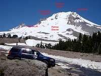
We reached The Dalles Oregon around noon time, where we stopped at Burgerville USA for lunch. From The Dalles it was only 21 more miles on I-84 west and then another 40 miles mostly along Oregon route 35 to the south side of Mt Hood and Timberline ski resort. We stopped a couple of times along route 35 to take pictures of the impressive 7,700 foot prominence of Mt Hood.
By 2:00 pm July 11, 2010 we reached the Timberline ski resort, and had our first look at Mt Hood’s south side.
By 2:00 pm July 11, 2010 we reached the Timberline ski resort, and had our first look at Mt Hood’s south side. I pulled out the route descriptions and maps and we began to pick out landmarks, and make speculations. I had read up on the Hogsback route as well as the South Side Old Chute Variation route, but I was hoping to also talk to someone about the routes to learn which would be best for the current conditions and so we headed for the historic Timberline Lodge.
Inside the lodge we noticed a park service employee at a table so we chatted with him but he did not have any information about the current climbing conditions. He suggested we go to the Day Lodge instead where he said there was a Climbers Cave. We followed his suggest and located the Climbers Cave, but there were no people there to chat with. However we did find the self-registry climbing permits, and a weather forecast. The forecast called for clear skies, much to our liking, but it also called for 30 mph wind gusts, something we had not anticipated. As we left the Climbers Cave I asked an athletic looking employee if he had climbed the mountain, he arrogantly replied that he had, and so I attempted to ask him the location of the Hogsback ridge on a ski resort map behind him. He did not want anything to do with me, so he responded that the map was a “cartoon map”, and I guess from that I was to infer how elite he is, even though his job appeared to be Mr. Trash-Collector. At that point in time I decided not to bother with trying to get anyone to tell us about the routes, knowing we could rely on the preparations I had made and the information I had.
Our next obstacle was how to kill the nine hours before we would begin our ascent. We found a not yet open campground, and asked a couple of Timberline employees if we could hang out until midnight, and they thought it would be okay. I spent 20 minutes or so organizing my gear, and then I made some instant soup which I ate along with a boiled egg. After the snack I laid out my tents footprint, a sleeping pad, and my sleeping bag under some trees and tried to catch some sleep while Josh rested in his car. As I lay under the large pine trees I watched the tops moving in the wind, as clouds moved rapidly across the sky. I kept hoping the wind would push the clouds away, and we would get the clear skies as predicted.
By 8:00 pm, rest was no longer needed nor welcomed, and we were both eager to do something, so we headed down to the town of Government Camp to see it there was anything there to distract us. Shops were closing soon after our arrival, so we ended up watching kids holding a talent contest at a skateboard camp. Soon we grew tired of that and decided to buy a pizza so we could kill time at a restaurant. With the loss of the sun, the temperature became quiet chilly and the air had a stormy feeling to it, which rapidly began to steal away our enthusiasm. The weather was becoming a genuine concern.
The Climb: Mt Hood HP #9 of the 50 US State Highpoints
By 12:30 am we were ready to go.
We measured out our rope and attached our prussics.
Josh turned his camera and got a couple of shots of me, the time was 7:00 am.
By 10:00 pm, July 11, 2011 we left the restaurant and headed back to Timberline stopping at a rest area to change our clothes. Our plan was to begin the trek up Mt Hood around 12:30 am to avoid the possible warm temperatures and soft snow of the afternoon. Reaching Timberline, we found the place to be desolate with the wind howling. In the afternoon the parking lot had been full of skiers and their cars, but now there was just one other occupied vehicle. I decided to approach that vehicle to find out if the occupant was there to climb the mountain, and learned that he was, but he did not seem to keen on talking. I next visited the Climbers Cave where I discovered another three members of his party; another guy and two girls. I just said hello to them, and pretended like I was looking for the weather forecast.
Returning to Josh’s car I filled him in on what I had discovered. I suppose knowing another group was about to head out spurred us into action ahead of our schedule. Getting ready in the cold, and dark, including making peanut butter and jelly sandwiches ended up taking much longer than we had anticipated, over an hour and a half. Part of the delay was reevaluating what we needed to wear due to the unexpected stormy conditions, but by 12:30 am we were ready to go as we formerly had desired. At this point we were about one hour behind the group of four. As we left the parking lot, and entered the climbers trail which follows up the east side of the ski resort on the Palmer Glacier, we noticed another two climbers, parked behind the Day Lodge, preparing to head out.
Big rocks, that looked like good seats, near the entrance of the climbers trail lured us into immediately putting on our crampons instead of waiting until further along in the climb when we would actually need them. The delay then had us starting at the same time (12:44 am) as the other two climbers, whom I asked about what route they planned to follow. Like everyone else we had encountered at Timberline they did not seem to want to depart with any information either, so we let them gain a little distance on us.
The distance from the 5,800 vertical foot parking lot to the top of the ski area boundary is about 2 miles as the crow flies, and about 2800 vertical feet. With the wind gusting steadily the groomed snow of the ski resort was very solid and at times the slope was just on the verge of being to steep to flat foot making the going a bit awkward and resulting in a lot of pressure on our heels. On resent previous outings Josh’s boots had caused some pretty sizable blisters on his heals, and so the awkward conditions were particularly rough on him. Even as tough and determined as Josh is, I will admit that I was worried his already tender heels might force us to turn around.
As we marched our way north up the ski runs with the wind gusting from the west and the clouds hiding the stars the gloomy feeling of the parking lot did not depart. All the same I kept hoping that once the sun came up the wind would die down, and the clouds would burn off. So on we went doing our best to stay away from the three or four grooming machines doing their nights work on the resort. Now and then we would spot the head lamps of the group of four, and a couple of times we caught up to the other group of two. With the colder temperatures, I noticed my head lamp getting dimmer and so I tried to hike along with it off, and Josh was doing the same. In spite of the darkness I could see the Palmer lift, and I was aware of Crater Rock above it. About three quarters of the way up the Palmer lift we past the group of two as they stopped to put on their crampons. Later on we would see their headlamps heading toward the west side of Crater Rock instead of the typical east side.
As we were nearing the ski areas upper boundary we began to think the group of four was coming down, as they definitely had stop ascending. That idea was another blow to our already lowered morale. Nevertheless we continued up, toward their lights, and eventually encountered them resting with their backs against the vertical wall of the upper boundary cat track in an attempt to stay out of the wind. This is the point where I had planned to rope up because we would be leaving the groomed terrain of the ski area. I asked the other group if they were planning to do the same but the fellow I had approached at his car informed us that it was not necessary yet. By this time we had learned that he was familiar with the mountain and I felt we could trust his opinion. As we ate a few snacks I brought up the subject of the wind, and learned that it was not common to be as strong as it was. Again I just hoped that with the light of day the wind would die down. While resting it did not take long to get cold, but I did not want to start out ahead of the other group, so we paused long enough to allow them to continue up first and then we followed. However we found their pace to be slower than ours, not surprising since we had already bridged the hour head start they had on us, and we soon overtook them.
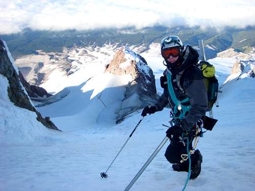
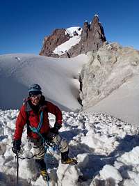
We could see Carter Rock above us to our left, but other than heading up we really did not know where in the dark we were going. There were other boot tracks and ski tracks so we felt confident we were on the right course. There appeared to be a ridge on our right, toward the Steel Cliff, and I thought if we could get over the ridge we might be out of the wind more or less. However as we pushed up, and to the right, it became apparent that there was not a ridge but just a shadow. As we got directly below Crater Rock on its west side we encountered a well packed trail in the crusty snow, and so we followed it north with just a hint of morning light starting to appear. By the time we reached the north end of Crater Rock dawn had arrived and we could see the Hogsback Ridge ahead of us, and the crater below us to our left; the time was 5:11 am.
The question we now faced was do we follow Hogsback Ridge up to the visible bergschrund of the Coalman Glacier and hope to find a way across it and into the Pearly Gates, or do we cross the crater and try to figure out where we go from there? The track we were on definitely entered the crater, through some avalanche debris, but was lost on the snowless hot rocks of the craters north west side. The crater was not that big, and I felt if we roped up we could safely cross it. So we measured out our rope and attached our prussics as the group of four caught up with us. As they past us we were able to ask them about the safety of crossing the crater and also have them point out the route to the summit ridge from the craters west side.
Without roping up the group of four walked down into the approximately 10,300 foot high crater and stopped to look at the fumaroles. Even so we completed our roping up process and then passed them as we crossed the crater. Getting on to the south side of 10,560 foot Crater Rock and on to the Coalman Glacier we were fortunately somewhat blocked from the main affects of the wind.
At the top of the hot rocks on the northwest side of the crater, the other guy in their group took the lead heading up the remaining 800 vertical feet solo. While the other three hung back to rope up. The slopes to the summit ridge were steep, 45+ degrees, but not as steep as I had several times in the past climbed. I took the lead on our rope and headed up confidently. My first inclination was to stay to the right of the main runnel, but I ignored that impulse and was drawn to the left by the solo climber. As we got higher, and the slope got steeper, the solid icy conditions made the going extremely dangerous and time-consuming. At one point my crampons failed to penetrate the ice and down I went, and even with my immediate self-arrest response I must of slide ten or fifteen feet before stopping.
The slip was a good thing because it reinforced to me how hazardous the conditions were, and so I began to pick my footings more carefully and would occasionally take the time to chop steeps with my ice axe. After we had crossed the height of the bergschrund we shorted the distance between us on the rope feeling there was no longer danger of breaking threw the snow and falling into a crevasse. Soon the solo hiker gained the ridge and dropped out of site, and the other three members of his group rapidly gained on us and shortly overtook us as they stuck to the right side of the main runnel. At that point I mentally kicked myself for not following my instincts. Then and there we knew we had to traverse the icy slopes to the right and gain the more established route they were on.
Josh took the lead on the traverse with the hope that his full shank boots would result in steps that I could follow in my half shank boots removing the need for me to occasionally chop steps. Alas, the snow was just too hard to form steps without chopping. Ultimately we gained the route of the other group, and quickly reached the summit ridge, where we were greeted by very strong gusting winds – well over the 30 miles per hour of the forecast.
We watched as the threesome crawled northeasterly on their bellies, across the knife-edge of the summit ridge, toward the peak. The wind gusts were so strong that no one dared to stand up least they be blown off the ridge and fall to their death. As we followed suit on our bellies, Josh who was in the lead, turned to me and yell through the wind, “Should we call this good”, and I responded “no” because I did not know if we’d make it back again to finish it. As we continued on not more that 10 feet I yelled at him, that maybe we should turn around. The wind was formidable, and we knew we were taking a huge risk pushing on to the peak, but nonetheless push on we did. At one point I instructed Josh that we had to be prepared to jump off the opposite side of the other, should the wind blow one of us off, thus arresting the others fall with the rope connecting us.
About the time we got over the hazardous knife-edge the other three reached the peak, but we still had not seen the fourth member of their group. Just shy of the peak we paused a few yards off the ridge, with slightly less wind, to put on our glasses/goggles, and the other three returned followed by their misplaced fourth member. Their leader informed us that they were not going to cross the knife-edge again on the descent but had spotted a different way down. I told them we would watch them, and we continued on to the peak as I took the lead.
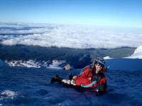
Shy of the peak Josh stopped so as to act as an anchor as I slithered to the 11,239 foot top of Oregon and had a look down the north side. A couple of minutes and we traded places. Josh was bold enough to take out his camera and go as high as a kneeling position while he snapped a few pictures. Lying down as his anchor I got out my camera and snapped a few shots of him, and a couple of Splattski’s of myself, as Josh turned his camera and got a couple of shots of me, the time was 7:00 am. It had taken us six hours and fifteen minutes to summit. We commented to each other that the winds felt like 60 or 70 mph.
The Descent
Not wasting anytime, and eager to get down to presumed safety, we started down after less than 10 minutes on the peak. We had seen where the other group had gone down, but at first glance I was not sure it was the fastest route, so we continued to back track toward the knife-edge, but once we reached it, the idea of shimmying down it head first was very unappealing. So we opted to mimic the other group’s descent.
Josh went first as I hung back to keep the rope between us tight. We took are time, and a few pictures, as we were again somewhat sheltered from the dreadful wind. As we continued down we finally saw the other two climbers who had started out at the same time as us, they were over the hot rocks and starting up the Coalman Glacier. We watch one of them slip and go a long ways, perhaps a 100 feet, before he stopped. That seemed to be enough for them, as they turned around and headed down.
Josh went first as I hung back to keep the rope between us tight.
Moving down slowly, we reach the crater just after 8:00 am. We snapped a few pictures of Crater Rock and the avalanche debris running into the crater, and then continued up to the Hogsback ridge where three of the group of four where resting. Upon chatting with them we learned that their leader was actually a Mt Hood guide, and that their fourth member had hurried on down as he was trying to complete biking from Portland, climbing Mt Hood and biking back to Portland within 24 hours. As a side note, Josh and I had actually seen him riding his bike up to Timberline along Oregon route 173 (Timberline Hwy) the previous evening. We thanked the guide for being there and allowing us to at times follow him. Given the current conditions, following his lead up to and over the knife-edge had definitely contributed to our success. We also discovered that the two girls with him were actually twin sisters.
Crater Rock and the avalanche debris running into the crater.
At the ridge, we took the time to relax, get some food and water in us and untie from our rope. After about 40 minutes of resting we resumed the descent. The views south over the ski resort, with Mt Jefferson on the horizon were amazing. To our right (west) was a sea of clouds, but straight ahead was clear. I had a feeling of freedom, and a major sense of accomplishment at this point, and the grimness of the night was replaced with euphoria. Even though the conditions had been challenging and the wind had been fierce we had been up for the challenge, and Mother Nature had allowed us to reach our goal. As James Ramsey Ullman had said we had escaped to reality!
As we rounded the east side of Crater rock, we were once again blasted by the west winds. As we approached the ski resort we literally where almost blown over at times, and began to be bothered by the persistence of the wind. A hundred yards or so above the resort the guide of the other group had left his Telemark skis, and so at that point he and the girls separated as we nearly caught up with them. I watch him attempt to go down hill into the wind on his skis and was not surprised as the wind actually pushed him up hill.
Our descent path took us to the top of the Palmer lift, where we discovered the twin sisters enlightening the ski patrol about their fatigue and asking if they could ride down on the lift. Eventually a ski patrolman agreed, and once he found a volunteer to fill the fourth spot on the chair, thus stabilizing the chair against the strong winds, down went the lucky twins the quick and easy way! Off I went down the groomed runs toward the climbers trail.
Near the bottom of the climbers trail I encountered the guide skinning up, and he asked me if I had found a pair of crampons, which the bike rider had lost, but regrettably I had not. Together Josh and I walked down the last 200 feet reaching the car before 11:30 am, both elated and exhausted, but happy about and thankful for another successful and safe mountain climb. While I removed my gear, and retrieved my left over slice of pizza from the evening before, Josh went into the Climbers Cave to get back the voluntary information sheet he had completed prior to our departure. When he returned he informed me that the updated forecast of that morning had called for 50 mph wind gusts, as we had certainly experienced.
Our defacto climbing partners were parked very close to us, and so we said our goodbyes, as they headed out for Portland and we left for Seattle and another northwest mountain. I now felt like I had come to know and firmly appreciate Oregon’s pinnacle, and I now had a first-rate and challenging experience with it to share.
Congrats on Hood! Awesome TR! I love that peak very much. Hood is much safer and better in May when the snow is better. For that route I actually prefer not to rope up because the crevasse crossings are very few especially early in the year.
Congratulations! I really enjoyed your write up. Sounds like you guys had some pretty serious wind up there. Your experience reminded me of my first Hood summit.http://www.summitpost.org/trip-report/599397/old-chute-2010-winter-ascent.html
This is a very good report. Great detail. This is a mountain that is on my radar. I think I will wait until spring though. I also had a bad time with severe burns/blisters on my heels on a climb.....not sure why though.
Great climb fellas! Good on you to persevere through the gale force winds! BTW, I-84 parallels the Columbia River [from just past the I-82 junction] through the beautiful state of Oregon .
Thanks for the name correction. I have change "Hood River" to "Columbia River". Mapquest labels a "Hood River" but that must be a town along the Columbia River.
I hope you don't mind me asking, but what is the name of the climbing club in Utah that you joined? I live in Utah County and I've been looking for a club that could teach me the things you mentioned above
Parents refers to a larger category under which an object falls. For example, theAconcagua mountain page has the 'Aconcagua Group' and the 'Seven Summits' asparents and is a parent itself to many routes, photos, and Trip Reports.


Comments
Post a Comment