
-
 124 Hits
-
 74.92% Score
-
 5 Votes
|
|
Mountain/Rock |
|---|---|
|
|
45.24710°N / 14.21470°E |
|
|
Hiking |
|
|
Spring, Summer, Fall |
|
|
2890 ft / 881 m |
|
|
Introduction
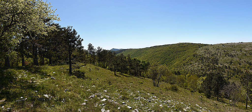
Perun is a secondary summit in the big massif of Učka mountain. It rises a bit off the main southern ridge, on the eastern, Kvarner bay side.
The summit is named by God Perun, the highest deity of Old Slavs. The fact that the mountain name is very old and that many toponymes in its surroundings have their names after other deities of Old Slavs or are named by archaic words of Old Slavs, that's the reason that many scholars believe that the area around Perun mountain was inhabited already in late antiquity with the first migration waves of Slavs who long retained their beliefs, habits and ethnic specifics.
Overview
From the coast of Kvarner bay some distinct valleys, almost canyons are being cut in the eastern slopes of the ridge of Učka. There are steep slopes, on many places high, vertical limestone crags, many karst caves and also precious water sources. Typical such valley is Mošćenićka Draga, named by the historic town of Mošćenice, perched on a steep hill just above the sea coast. The valley rises towards the NW, higher towards the W, and south of its upper part rises the forested Perun mountain.
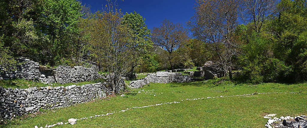
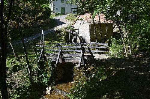
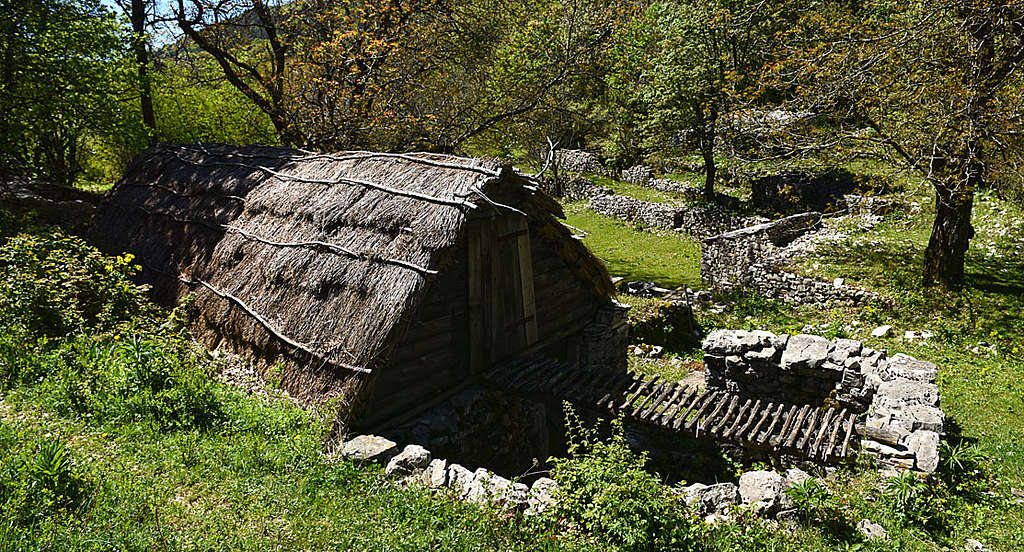
In a mountaineering sense Perun is really nothing special. Unlike many other summits in the Učka massif it even offers no broad view around. And yet the ascent on Perun can only be recommended. Nature there is really beautiful. Especially high meadows near the main Učka ridge are heaven on the Earth. Come there is spring and the line between reality and myths will quickly start disappearing. Then add to nature also ethnological pearls and you'll not need those fairy-tale stories for tourists any more. Your immagination can do all the job. Just think that people lived in caves above Mošćenićka Draga already in neolithic times, that Liburnian tribes used those meadows as pastures, that you are walking by connecting paths older than 2000 years, bordered by dry stone walls. And shepherds huts are still as they were in those times - simple, made of dry stone, covered with straw roofs. Lower hamlets in the valley are still inhabited and renovated into nice dwellings.
Getting There
Perun summit can be reached from all sides, but the majority of hikers come through the valley of Mošćenićka Draga. The other two possible trail heads are the town of Mošćenice more towards the south and the village of Mala Učka on the N-NW. Only over the high western slopes of Učka ridge almost nobody ascends. Here is the list of some trail heads (see also the interactive map below):
- Parking 135 m in the valley of Mošćenićka Draga. N 45,246016°, E 14,238882°.
- Obrš village, 293 m. N 45,249105°, E 14,250732°.
- Mošćenice town, 168 m. N 45,226251°, E 14,248551°.
- Parking 1011 m, north of Mala Učka village. N 45,282587°, E 14,192641°.
Routes Overview
In the next chapter I will describe in detail the most recommended route - from Mošćenićka Draga valley. But let's first describe here only key points of all three routes:
From Mošćenićka Draga Valley
A round tour is most rewarding. From the parking down in the valley you go by the road towards Obrš, but half way up you turn left and continue through the hamlets on the northern slopes of the valley. In Trebišća hamlet you cross the creek again, continue westwards up on Petrebišća meadow and on the summit of Perun. In return you go from Trebišća hamlet directly by the valley down. For the whole round tour you need some 4 hours.
From Mošćenice Town
There are many variants and due to the more southern trail head the tour is longer. The easternmost variant traverses the slopes of Perun, reaches Trebišća hamlet and from there continues on the summit. The middle variant goes a bit more directly - by a non-marked cart road through the abandoned hamlet of Grabrova and across the E slopes of Perun on Petrebišća meadow and on the top. The third variant is an officially marked trail of Croatian Mountaineering Organisation. It goes westwards to Mihani hamlet and then northwards more directly on Perun. All these variants can be combined into round tours, requiring some 5 hours of walk.
From Mala Učka Village
This picturesque, abandoned village can be almost reached by car from the north, from Vela Učka village, on the road over Poklon road pass. The parking lot is on 1011 m, some 15 min before the village. From Mala Učka village two marked paths continue towards the south (and can be combined into a 12 km long round tour). The eastern path reaches Petrebišća meadow directly, the western one keeps more to the main ridge and joins the first one on the saddle west of Perun.
Perun From Mošćenićka Draga
In addition to the valley, Mošćenićka Draga denotes also a bay and town on the Adriatic coast. From there the road goes into the valley. The most simple tour on Perun goes by the valley bottom. But more rewarding is a round tour, on which the ascent to Trebišća hamlet goes north above the valley. For that traverse, going through many picturesque hamlets, the trail head could be also in Obrš village. But having car there, that would mean also walking up there on the route return.

It's best to park down in the valley, on 135 m, where the Obrš road turns right and straight by the valley bottom goes only a narrow cart-road, closed for public traffic. We start walking by the asphalted road up towards Obrš, but already on 238 m we deter left, on a more narrow asphalted road towards Sučići. Leaving that hamlet on the right, we continue to Draga hamlet, above which we take a marked shortcut to the left. Higher we gain the cart-road again, but it soon ends. The path above the houses of Jurčići is very picturesque, that's the old trade route to ex moulins in Trebišća. We reach that hamled almost horizontally.
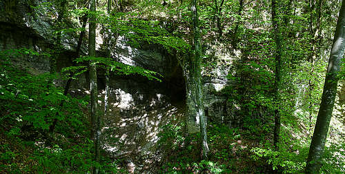
In Trebišća, 428 m, we cross the creek and start ascenting in several turns towards the west. Over forested slopes we gain a crossroads on a distinct left turn on 566 m. There goes to the right the path to Voloski kuk. That's another mythical place of this area. High crags with overhang, perhaps a cave and a nice, small waterfall were supposedly the dwelling of Veles god - the master of underworld. From the last viewpoint we then return on the broad marked path and continue by it up towards the west. Soon it comes to a water cistern where we cross a cart-road, following inscriptions for Petrebišća. We reach the alpine meadow in less than 10 minutes.
Petrebišća (on some maps also: Potrebišća) is an old shepherds settlement of incredible beauty. The ancient arcitecture is mostly preserved, but the majority of huts is abandoned. Also the meadow is nice and broad, occupying the area between Perun and main Učka ridge. A pond, meadows, dry stone walls built perhaps even in prehistoric times. We pass a sculpture of Veles-the-snake and a bit towards the south there is a broad saddle, where we turn left. We soon leave the cart-road to the right, following the blue marks to Perun.
The last ascent goes around the summit, on the northern slope and then right up on the forested summit. Just before it we reach a wooden sculpture of Perun, a bench and an explanation table, but the real summit is some 5 minutes further to the south.
When to Ascend

You can hike up on Perun almost any time of season. But far the best season is spring (May), eventually also a colourful autumn (October).
Huts And Camping
All variants of tours can be done in one day, so sleeping on the mountain is not needed. But longer traverses of the Učka ridge are also very rewarding and they may require sleeping near the ridge. In abandoned shepherds huts you may find a good shelter and if you set up a tent on the meadow (just over the night) nobody will enforce any prohibition of the Učka Natural Parc. SW of the summit of Perun, on the main ridge of Učka, there is a Hunters hut Perun (N 45,237434°, E 14,203917°) and a bit south of it, on the other side of Brgud summit, also a Hiking shelter Kremenjak, 847 m (N 45,224493°, E 14,206545°). In the hamlets of Mošćenićka Draga you will not get food and drink, but there are some good water sources.
Red Tape
Big area of the upper part Of Učka and Planik massif are declared a nature park and the whole area of Perun mountain and the upper part od Mošćenićka Draga are a part of it. See its rules of behavior and its most distinct features on the official page of the park.