Overview
![Puig des Coll des Jou (1052m), Puig des Cornadors (1013m)]() Puig des Coll des Jou (1052m), Puig des Cornadors (1013m)
Puig des Coll des Jou (1052m), Puig des Cornadors (1013m) is part of
Serra de Alfàbia, a southwest to northeast running ridgeline of karst mountains among
Serra de Tramuntana on
Mallorca. It is located rather centrally in the bigger range between the tourist (hiking) hotspots of
Sóller in the north and
Orient in the south. It is located close to
Barranc de Biniaraix and its surrounding mountains,
Cornador Gran and
Puig de'lOfre. Yet, it is climbed much more rarely than these other mountains, thanks to its slightly more inconvenient location. It is usually climbed together with
Cornador Gran, by following the route through the
Biniaraix Canyon, which itself is one of the most popular routes on the island.
Like its surroundings
Puig d'es Cornadors is made up from limestone. In fact its east face towers some 300m above one of the karst valley, which are so typical for
Serra de Tramuntana. You can reach it from
Coll d'es Cornadors from the north , the saddle, which separates it from
Cornador Gran. Here a triangular slope leads up to the summit, narrowing more and more as you go. On both sides big drops lead to the karst plateaus and valleys underneath.
Puig d'es Cornadors is the first (or last) summit of the
Serra de Alfàbia traverse, which starts and ends in
Sóller. It is a rather serious undertaking thanks to the roughly 1500m elevation gain you have to scale. Also, while marked on maps, the route leads through private property, which can be closed to tourists any time. Still the traverse is one of the big hikes of the island, mainly thanks to the views across Sóller Valley towards the sea.
Some words about
Barranc de Biniaraix: it is a narrow and - in its eastern end – very steep canyon which runs from
Sóller towards the karst plateaus of
Serra de Tramuntana. On one hand it has been used as a pilgrimage trail between the sanctuaries on both sides of the range. On the other it has become a rocky field and garden for
Biniaraix itself. There are lots of olive trees in the lower part of the barranc and there also are farmsteads within it. The trail itself has been paved with cobblestones and today makes up one of the most popular parts of the GR221 trekking trail.
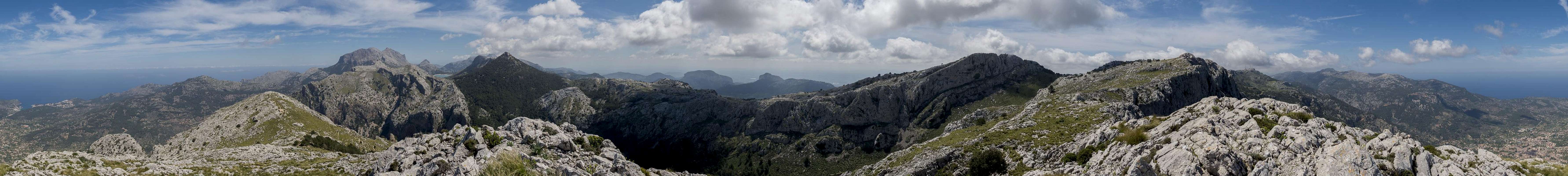
360° Summit Panorama
360° summit panorama from Puig d'es Cornadors |
Getting There
![Serra de Alfabia]() Serra de Alfabia
Serra de Alfabia
A typical tourist location, the island
Mallorca can be best reached by plane. There are flights from virtually every European international airport to
Palma de Mallorca. From the island capital the following itinerary leads to the most common trailhead at
Biniaraix:
- Take motorway Ma-19 from the airport to Palma.
- Switch to motorway Ma-20, the circumnavigation of Palma.
- leave it for Ma-11, direction Sóller
- You can reach the trailhead at Biniaraix by driving through Sóller, however, it's easier to pass by the town and switch to Ma-10 afterwards.
- Take the exit Fornalutx and pass through the village.
- The road (Ma-2121) heads back to Sóller through Biniaraix
Route
![Penyal de Migdia and Puig Major]() Penyal de Migdia, Puig Major, Puig de'l Ofre
Penyal de Migdia, Puig Major, Puig de'l Ofre
The one route to
Puig d'es Cornadors which is hiked by 100% of its visitors runs through
Biniaraix Canyon, a narrow gorge which connects the village
Biniaraix with the Sierra de Tramuntana high plateau. The regular route runs along a paved road-like trail, which stays in the canyon centre for the lower half before travesing through the north and east faces of the curving canyon. There is an alternative, a path up the south slopes above the canyon, which heads for the cave
Cava de Alfabies before rejoining the common route where it starts the face traverse.
Once out of the canyon you turn right and head for the east ridge of
Cornador Gran. At its base the path turns south, taking you to the saddle between
Cornador Gran and
Puig des Cornadors. A short hike up the karst slope and you stand on top.
Red Tape
There appears to be no red tape here even though the route runs over cultivated land. However, there is an acute shortage of parking spaces at
Biniaraix.
When to Climb
Puig d'es Cornadors can be climbed all year round. The best season is from November through May. Avoid the hot summer months.
Accommodation
![Summit view across the valley of Sóller]() Sóller Valley, where all kinds of accommodation can be found
Sóller Valley, where all kinds of accommodation can be found
Generallly, there are lot of accommodation options on
Mallorca, which you can find on the usual portals. Prices, however, are quite high.
Sóller is the hiking capital of
Mallorca. There is a lot of accomodation there and even more in Puerto de Sóller on the coast.
Weather Conditions
The right clothing provided, the mountain can be accessed in any weather condition.
Maps & Books
There are many publications about hiking on Mallorca. I include the ones which I have used myself as well as recommendations by other SPers. The book by Rolf Götz, which is available in four languages has a good choice of routes, two thirds of them in Serra de Tramuntana. Two routes are dedicated to
Massanella.
In particular I want to recommend the book by Marc Schichter & Kirsten Elsner, even though it is only available in German. It comes with an excellent map of
Serra de Tramuntana (probably the best available) and lots of routes which can be connected at will.
Maps
- Mallorca
4 map box set
Kompass Verlag
1:35000
ISBN: 978-3-99044-062-9
- Walk Mallorca
Discovery Walking Guides
1:40000
ISBN: 978-3-99044-062-9
Books
- Mallorca
Rolf Götz
Rother Verlag
ISBN: 978-3-7633-4805-3 (English)
ISBN: 978-3-7633-4122-1 (German)
ISBN: 978-3-7633-4923-4 (French)
ISBN: 978-3-7633-4701-8 (Spanish)
- Wandern auf Mallorca
Marc Schichter & Kirsten Elsner
Reise Know-How
ISBN: 978-3-89662-289-1
- Walking in Mallorca: Classic Mountain Walks in Mallorca
June Parker
Cicerone Press
ISBN: 978-1852844882

 3065 Hits
 76.66% Score
 7 Votes
 Puig des Coll des Jou (1052m), Puig des Cornadors (1013m)


 Serra de Alfabia
 Penyal de Migdia, Puig Major, Puig de'l Ofre
 Sóller Valley, where all kinds of accommodation can be found