
-
 94621 Hits
-
 93.35% Score
-
 42 Votes
|
|
Mountain/Rock |
|---|---|
|
|
45.24510°N / 117.29298°W |
|
|
9838 ft / 2999 m |
|
|
Overview
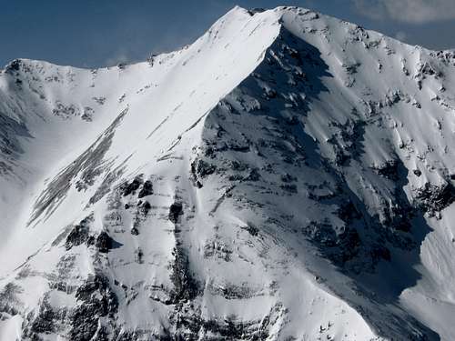
At 9838 feet high, Sacajawea Peak is the disputed highest peak in the Wallowa (pronounced wuhl-OW-uh) Range of Eastern Oregon. The ranger station and most literature/websites will tell you it's higher than the Matterhorn (at 9826 to 9845 feet depending on what you are reading) but until a definitive study is done, the debate continues.................. Whatever it is, Sacajawea Peak is also the 111th most prominent peak in North America with 6,377 feet of topographical prominence.
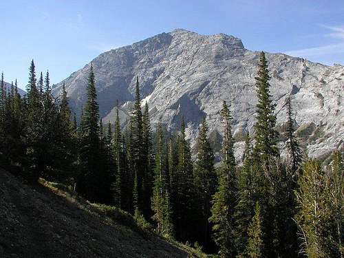
Sacajawea appears to be a red scree mound from the east and south while it has grey cliffs on the north and west, a testament to the strange and wonderful range of mountains it is in. It stands between the Hurricane Divide and the Hurwal Divide and just north of Matterhorn. I've been able to find 3 possible routes to its summit. The hardest is the ridge from the Matterhorn that is 3rd class in spots although if you are not able to find the correct Class 3 route along the spine, you could traverse lower on the west side in scree around the gendarmes if needed. A climbers path leads from the summit of the Matterhorn to a subsummit on the ridge and even a bit further north to a large gendarme. The easiest way is to hike in Hurricane Creek Trail to Thorp Creek Trail and up the east ridge non-technically. It also is possible to come directly from Ice Lake across a saddle in the Hurwal Divide and up lots of red scree on the southeast side.
The Wallowa Range is very different from anywhere else in Oregon. This is supposed to be an offshoot of the Rockies into Oregon and is one of the few places, if not the only, where there is granite in Oregon. But before you start thinking there's finally a place with solid rock, think again. This site gives the details of the geology but suffice it to say that it started with a volcanic chain in the Pacific that erupted, continued with sediment being laid down, followed by tectonic plates slamming into each other, then followed by more volcanic eruptions and finally glacial erosion. Add this together and you get huge granite walls thousands of feet high, limestone ridges and red and yellow volcanic rock giving it a most unique quality. The mountains also are forested with alpine meadows, lakes and waterfalls and are called the Switzerland of America. A truly amazing place.
 |
 |
 |
 |
 |
Getting There
From the east or west you take I-84 to LaGrande, OR. There take exit 261 (Highway 82) east for 65 miles to Enterprise, OR.
If going in via Hurricane Creek, take Hurricane Creek Rd. of the main drag in Enterprise south for about 10 miles. Follow signs to Hurricane Creek Campground and go to the end of the road.
If going in via Ice Lake/the Matterhorn, continue from Enterprise on Highway 82 south to Joseph, OR (about 6 miles) and follow signs around the Wallowa Lake to Wallowa Lake Trailhead at the end of the road. See also this route for directions to the Wallowa Lake Trailhead.
Red Tape
A Northwest Forest Pass is required to park at the trailheads.
When To Climb
July to about mid-October depending on snow. (lots here in the winter)
Camping
Public campground at Wallowa Lake Campground.
Free camping at Ice Lake and anywhere in the wilderness as long as you are off trail and away from water.
Mountain Conditions
Eagle Cap Ranger District
Hells Canyon National Recreation Area
201 East Second Street / PO Box 905
Joseph, OR 97846
Phones: 541-426-5546, 541-426-4978 fax: 541-432-0693