
-
 6088 Hits
-
 87.76% Score
-
 25 Votes
|
|
Mountain/Rock |
|---|---|
|
|
47.02644°N / 11.64280°E |
|
|
Tyrol |
|
|
Mountaineering |
|
|
Spring, Summer |
|
|
11191 ft / 3411 m |
|
|
Overview
Geographical classification: Alps - Eastern part > Zillertal Alps > Schrammacher
Schrammacher 3411 m
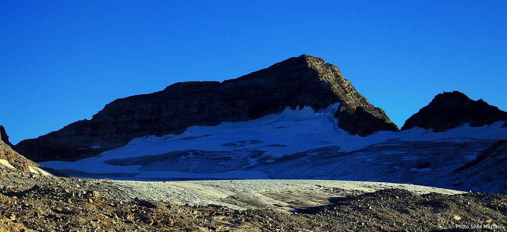
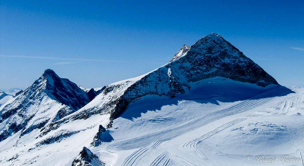
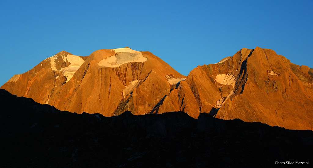
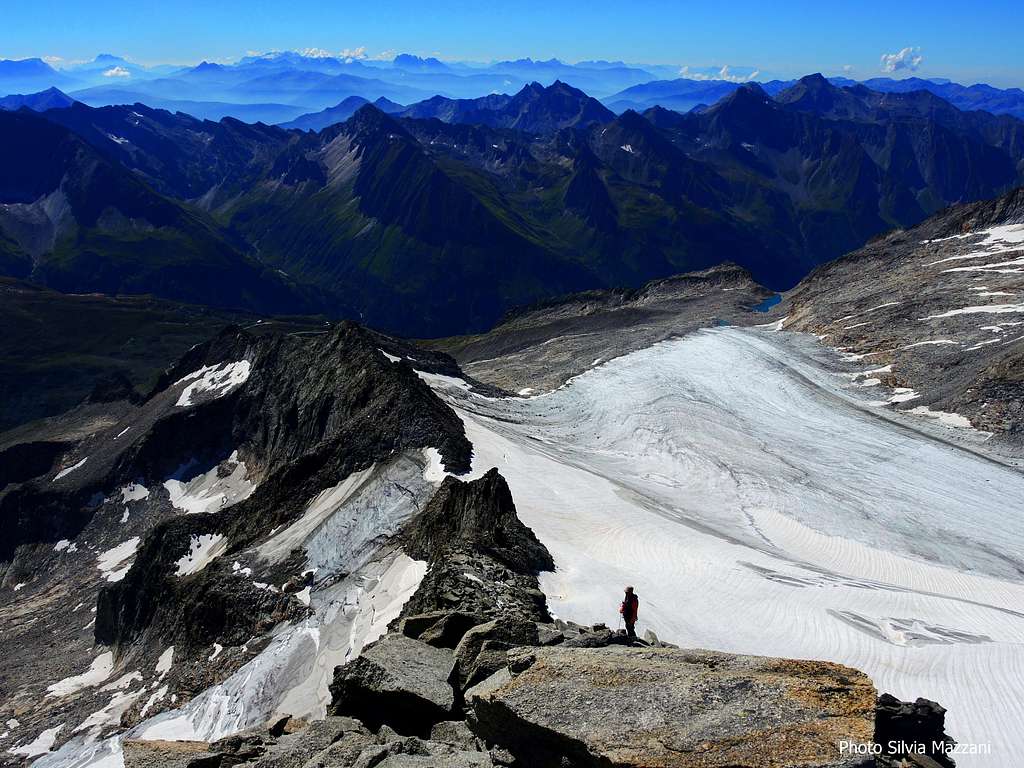
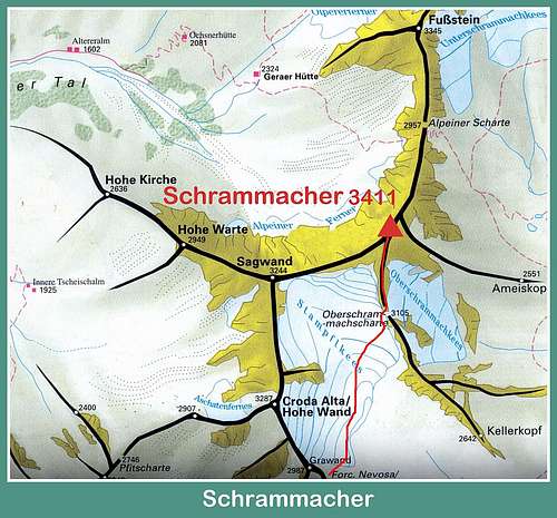
Schrammacher 3411 m is a wild and superb pyramidal mountain, belonging to the Zillertal Alps range and situated nearby the Italian-Austrian boundary ridge, entirely on the Austrian side, between Sagwand to SW and Alpeiner Scharte to NE. Despite it inspires a bit of awe, Schrammacher is a sought after peak, showing three main ridges – South, SW and NE – which identify three main sides: the mighty SE side overlooking the wide Stampflkees Glacier, in strong retreat, the wild East side overlooking the Oberschrammachkees Glacier and the steep and severe NW side. This latter wall is extremely severe, showing a few challenging routes on mixed ground, very rarely frequented.
On the contrary the Normal route starting from Passo di Vizze, on the Italian side, is a very good and fairly easy route, crossing at first the wide Stampflkees Glacier, in pronounced retreat, and successively following the South Ridge of the peak. This route is often climbed in reason of its interest and the wide and superb views over the glacier and the surrounding mountains, both on the austrian and italian sides.
First ascent: J. Huber, G. Lechner and Peter Karl Thurwieser 19-8-1947 along the South Ridge
Getting There
Road Approach
The starting point to climb Schrammacher Normal route is Passo di Vizze – Pfitscher Joch 2251 m.
Getting to Val di Vizze
- From Brennero Motorway exit Vipiteno-Sterzing 947 m (Italy) and take the road n. 508 entering Val di Vizze and reaching the villages of Prati-Wiesen, Caminata-Kematen, San Giacomo-St. Jacob and Sasso-Stein m. 1508, where the road becomes unpaved. The road rises quickly towards Passo di Vizze, but cars are allowed as far as the IV hairpin m. 1806. Parking.
Approach to Passo di Vizze – Pfitscher Joch m. 2251
The road from Sasso to Passo di Vizze is open to private vehicles as far as the IV hairpin along the road at the altitude of 1806 m. From here take a path to the North (signposts «Pfitscher Joch»), or alternatively carry on briefly along the road, then turn to left following the path n. 3. 1 hour and a half. Otherwise a minibus service is available with frequent departures both from Sasso-Stein and Passo di Vizze.
Schrammacher South Ridge – Normal Route from Passo di Vizze
Schrammacher South Ridge – Normal Route from Passo di Vizze
Summit altitude: m 3411
Difficulty: Alpine F+
Vertical gain: 1160 m from Passo di Vizze m 2251
Exposure: South
Hut: Rifugio Passo di Vizze m 2275
Starting point: Passo di Vizze m 2251
Quite a worthwhile route inside a spectacular setting!
From Rif. Passo di Vizze 2275 m descend briefly the dirt road reaching Passo di Vizze 2251 m in a few minutes. From the col, near a building and a small lake, turn to left taking the path to Rif. Europa, but after 20 meters, at the signpost, leave immediately the main path and head to right (AVS signpost “Schneescharte”) taking a good and well-worn path (stone-cairns), rising directly along a vegetated and stony slope.


In the higher part the path head to right passing across a stretch of granite boulders and getting Schneescharte-Forcella Nevosa 2789 m, near the starting point of the glacier, characterized by a tiny charming lake, that collects a portion of the melting waters of the glacier. From here it appears the Schrammacher South-East wall bordered on the right by the obvious ridge (South oriented) along which it’s running the Normal route.


After being tied, we start to cross the Stampflkees Glacier rightward, at first gently, then more steeply, reaching the middle of the glacier and getting the upper great basin. From here we climb a steeper icy slope heading towards the wide and obvious saddle named Oberschrammachscharte, snowy in early season, located upstream the glacier along the baseline and flat starting part of the S ridge. The saddle is easily recognizable because it’s dominated by a rocky pinnacle. Once we get under the vertical of the saddle, we don’t climb directly to it, rather we continue briefly to cross the glacier to the left to reach the bottom of a steep snowy cone.


After crossing the bergschrund, sometimes open and a bit difficult, especially in late summer, we climb the icy slope, about 80 meters long, and we set foot on the ridge, snowy in spring or early summer, entirely rocky in middle and late summer.


Now we turn to left and start to climb the ridge, mainly keeping ourselves on the edge, but occasionally moving now to the right, most exposed, now to the left of the wire to seek the better steps. Beyond a flat brief section we reach the base of the upper steeper step (crux, safety sling in place). Passed this short step, we reach the wonderful summit (summit cross and summit book). Unforgettable views!


Descent: reversing the same route
Essential gear
Rope, slings, some carabiners and full glacier gear
Other routes
- NE Ridge
- NW Pillar
- NW wall
- Route Daschfure NW wall
- Route Baumgartner
Red Tape

Saxifraga Bryoides, Zillertal
No fees no permits needed. The peak is located within the Zillertal Alps Natural Park, a wild and preserved environment.
Hut


- Rifugio Passo di Vizze m 2276
When to Climb
Mountaineering: from middle June to the end of September
Ski-mountaineering: from March to May
Meteo
Meteo Provincia Bolzano
Meteo Tirol
Guidebooks and maps
 |
 |
Guidebooks
“Alpi Aurine” by F. Cammelli – W. Beikircher Guida dei Monti d’Italia CAI
Maps
"Zillertaler Alpen - Tuxer Alpen" - Kompass 1:50.000