Introduction
![Meadows and Rock]() Dürrenstein / Picco di Vallandro seen across Sarlriedel Dürrenstein / Picco di Vallandro seen across Sarlriedel |
For most of us there are mountains which don't fit, mountains which seem to have a will of their own and which won't let you get to their top, no matter what you do. For me the worst foe of that type is
Peitlerkofel / Sas da Pütia, which has thwarted me twice and which afterwards had the nerve to smile mockingly down on me as I returned to my car and took off. But this account is not yet closed and in the end I will be the one to be mocking! Similarly there are other mountains which I had given up climbing in my early days and on which recently I have been able to get my own back, one of which is
Dürrenstein / Picco di Vallandro, the second highest standalone mountain in the
Prags Dolomites / Dolomiti di Braies.
It is a beautiful mountain with an easy ascent route which on a fine day can lure hundreds of people to its summit. It is famous for its panoramas towards the
Sexten / Sesto Dolomites as well as the
Prags / Braies Dolomites and thus a must-go for anyone who visits the region. Ten years ago, in September 1999 we tried twice to climb it, both times being defeated by rainy weather. During the second attempt we were willing to go to the top no matter how much rain would pour down. But then rain turned into storm – storm turned into thunderstorm – thunderstorm turned into flood. And we fled the inhospitable mountain blotting it out of our minds for a whole decade.
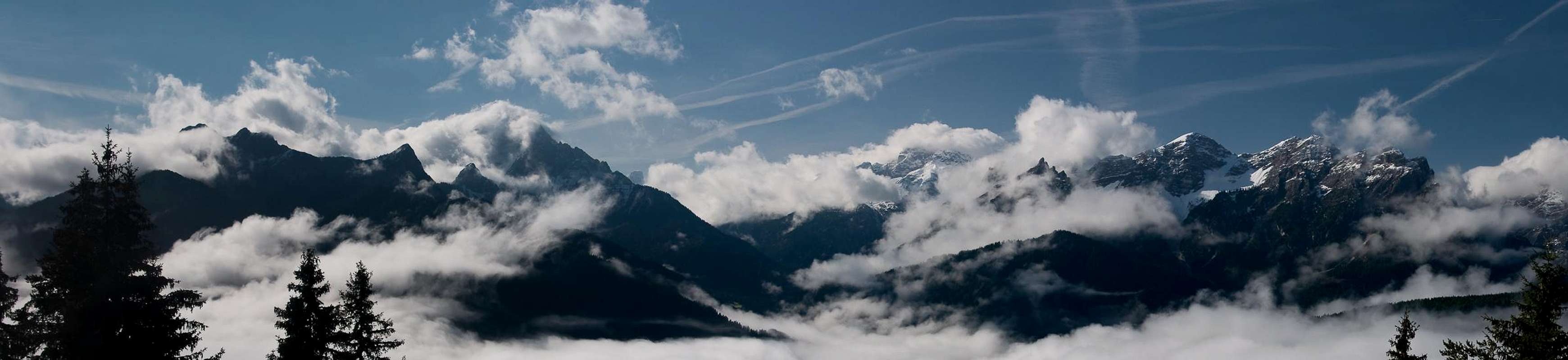
![Dürrenstein / Picco di Vallandro]() Dürrenstein / Picco di Vallandro as seen from the summit of Großer Roßkopf
Dürrenstein / Picco di Vallandro as seen from the summit of Großer Roßkopf
But then we returned with our base at
Sexten / Sesto. The early days of the vacation had re-introduced us to the beauty of
Dürrenstein / Picco di Vallandro. And then a bad weather window arrived, forcing us to low and easy places – even spoining a whole day by not letting us go outside. And then – right in this bad weather window we found ourselves at the base of the mountain again.
What would we do?
Boredom!
Sunday September 13th
![Looking out of Forcella Urtisel]() Looking north from Forcella Urtisel, Monfalcon Group
Looking north from Forcella Urtisel, Monfalcon Group
We have just returned from a hike in the
Monfalcon Group of the
Dolomiti Friulane. The trip has been nice but the weather has turned for the worse during the day. It has even rained for two or three periods. And now the weather forecast tells us that the weather will get worse tomorrow and stay as bad for at least the next five days. It's not as if so far we have had perfect weather!
Monday September 14th
Back again from a round trip through the Dolomites. Our plans to do something near
Pieve di Cadore were drowned by torrents of rain. We drove the car to
Cortina, to
Toblach / Dobbiaco and back to
Sexten / Sesto again. The weather forecast has extended the bad weather for another day!
Tuesday September 15th
![Gsellknoten]() Gsellknoten seen from Sexten / Sesto
Gsellknoten seen from Sexten / Sesto
Snow on the mountains! I look out the window and see
Haunold and
Gsellknoten under a thick layer of snow. Weather is supposed to be unstable today so what can we do? We decide on a ridge hike between
Welsberg and
Toblach, called
Römerweg. According to legend the Romans already established this trail but there's reason for doubt that the story is true.
The trail runs through the forest and there is little to see. There's a fogbow – here are some interesting light patterns. But our feet are getting real wet with all the humidity in the ground. Finally a view towards the
Prags / Braies Dolomites! Heavy clouds everywhere, especially around our friend
Dürrenstein.
Prags Dolomites in the clouds. Dürrenstein is left of centre |
Wednesday September 16th
![Cascades in Wielental]() Cascades in Wielental
Cascades in Wielental
Another day for the road! Or so it seems. We drive to
Cortina, then across
Falzarego Pass to
Corvara and back north to
Bruneck / Brunico. There the rain stops and we think we see a patch of blue sky in the north. We follow it and park at
Oberwielenbach / Vila di Sopra. The remainder of the day we hike through
Wielental, a valley which runs deep into the
Rieserferner Group. Not much to be seen nor to be climbed. We gotta be happy with some of the cascades we see in the creek. At night the weather forecast still calls for the same type of weather...
Frustration
![Rudihorn (2448m) and Eisatz (2493m)]() Rudihorn (2448m) and Eisatz (2493m)
Rudihorn (2448m) and Eisatz (2493m)
After all this non-climbing we really are frustrated as we get up on Thursday. A look outside doesn't promise anything better than in the previous days. Nevertheless we get ourselves ready and decide to drive into the wide
Pustertal / Val Pusteria. Maybe we have a chance there? However, in the valley there is ground fog (a good sign?) and we decide to go north like yesterday.
Gsieser Tal / Valle di Casies might be an alternative. There is a route in one of our guidebooks which runs all the way to the end of the valley and up some pass. Maybe we can sneak a view to the other side. But we fail even before we start. We don't find the parking lot near the chapel in St. Martin and drive by. A few km onwards there is a chance to turn the car and back we go. What a start for this day!
But wait a minute! Way down south – across
Pustertal / Val Pusteria there is blue sky! What about going to
Plätzwiese / Prato Piatta? I ask Judith and she agrees – the chances are slim but why not.
Plätzwiese is a big pasture in the
Prags / Braies Dolomites, located at roughly 2000m. You can drive there by car but have to pay a 5€ toll for the car. We''ve been there before. Twice. When we tried to climb Dürrenstein / Picco di Vallandro ten years ago ...
A Good Omen?
Plätzwiese
![Looking across Plätzwiese towards the Cristallo Group]() Plätzwiese / Prato Piatta
Plätzwiese / Prato Piatta
Once we have a goal I step on the gas and speed my car out of
Gsieser Tal / Valle di Casiês and into
Pragser Tal / Valle di Braies. There's construction at the mouth of the valley and a traffic lights stops our progress. But only temporarily. Soon we are dashing along again. At 8:30 a.m. We get to the toll station. We seem to be among the first to drive up, shed out 5€, and up we go. Soon we get stuck behind an elderly Italian couple in their small Opel but they make way for us at the earliest opportunity. Then another traffic light! The final road to
Plätzwiese is a one way road which is opened for each direction for 5 minutes for every 15. Naturally the light has just turned red. The Italian couple stop behind us. So much for my speeding!
Green! And off I go. Three minutes and I'm at the upper parking lot. There is only one car around as I park mine in the pole position. Out we jump, boots, backpack, camera and GPS. And then a check – where do we go?
We look around –
Plätzwiese is in a damp early morning sunshine. Everything is crisp and clean but looks incredibly wet. To the west
Hohe Gaisl / Croda Rossa looms but its bulk is hidden in fog. To the south, where
Cristallo must be, is another huge cloud. Only behind us – in the north-east – there is a huge slope, in fact a giant ramp:
Dürrenstein / Picco di Vallandro. Shall we go? Will we have a chance to succeed this time? Shouldn't we wait for a day with better views?
We look at each other – then slowly nod.
Let's try it - NOW!
The Usual Slow Start
![Hohe Gaisl / Croda Rossa]() Hohe Gaisl / Croda Rossa
Hohe Gaisl / Croda Rossa
Though we definitely know we have to speed up to get to the summit before the fog blots out everything, we run into problems from the start. First the hiking poles need to be adjusted, then the boots. Both of us are looking for a place to let nature run its course. But no decent bushes can be seen around. So we walk over to Hotel Plätzwiese, where the hiking trail to
Dürrenstein starts and slowly get our bodies moving up the slopes. The ground is incredibly soggy. We slip and slide more than that we hike. Then the first bushes ...
(While I ask you to avert your eyes, a few notes on the mountain we are about to step upon. Dürrenstein / Picco di Vallandro is one of these Dolomite mountains (like
Plattkofel / Sassopiatto or
Peitlerkofel / Sass da Pütia) which to one side shows a huge face – here it is the north-eastern one – while the opposite side is a giant slab. Reaching close to the summits of these mountains is easy but often an exposed ridge traverse finishes off. In the case of
Dürrenstein, the north-west face is well structured into several "pyramids", all of which are famous climbing destinations. Overall the face is about 3km long.)
![Pustertal / Val Pusteria]() Looking across Castello Glanvell into Pustertal / Val Pusteria
Looking across Castello Glanvell into Pustertal / Val Pusteria
Stepping out of the bushes we turn back on the trail again and get going. All around the fog is lifting and we figure we might actually get lucky. Behind us
Cristallo makes a first appearance, to the Left it is
Hohe Gaisl / Croda Rossa. And the
Dürrenstein summit is still up front. But then we are treated to a wonderful show. Clouds come and go and if you pick the right time you get to see all summits nearby. It seems like someone is giving us smoke signals!
![Smoke signals around Monte Cristallo]() Smoke signals around Cristallo
Smoke signals around Cristallo
The track starts to wind. We notice that two parties, both couples, have had a start on us but we are drawing close. Then we pass the first couple – Germans of course – "Hallo" and we push ahead. The two seem to be having trouble with each other. An argument seems to be going on. She wants to get going but he seems to be out of breath. We soon lose them from our radar. Now we're reaching the first snow fields. Luckily most of the snow from Tuesday has already melted. Still we're not quite sure what awaits us on top. Guidebooks claim there is a difficult protected section right underneath the summit. In snow this might be tricky.
We reach the ridge in a saddle between the main summit and the first pyramid (southern side summit). The north-west face is covered in fog but the ridge appears to be clear enough. Looking up and down we see more smoke signals being waved at us. If we only knew what they mean! To our west, underneath the big ramp a section of limestone towers presents itself. The largest one is
Torre Glanvell and from our vantage point it seems to hover high above
Pustertal / Val Pusteria. We're getting ready for the final part of the climb.
![The Dürrenstein summit]() Before the "crux"
Before the "crux"
Behind us a young hiker gains on us. He seems to be jogging up the mountain. We let him pass and of course he is German as well. In front of us the second couple is getting to the protected section. They also let the young guy pass and then try to negotiate the "crux". Somehow they get stuck and we catch up. The crux is a 2m drop, protected by a chain. Without the chain there would be no difficulty but as it dangles between their legs the 2m pose a challenge to the couple in front of us. We wait our turn, then quickly make it down to the little saddle. The other couple (did I already mention they are Germans?) takes a wrong turn and ends up on an "exposed" ridge. We pass them through the snow underneath and thus are number two and three on the summit. Still no rain and you could even claim that there are some views.
Summit Before the Crowds
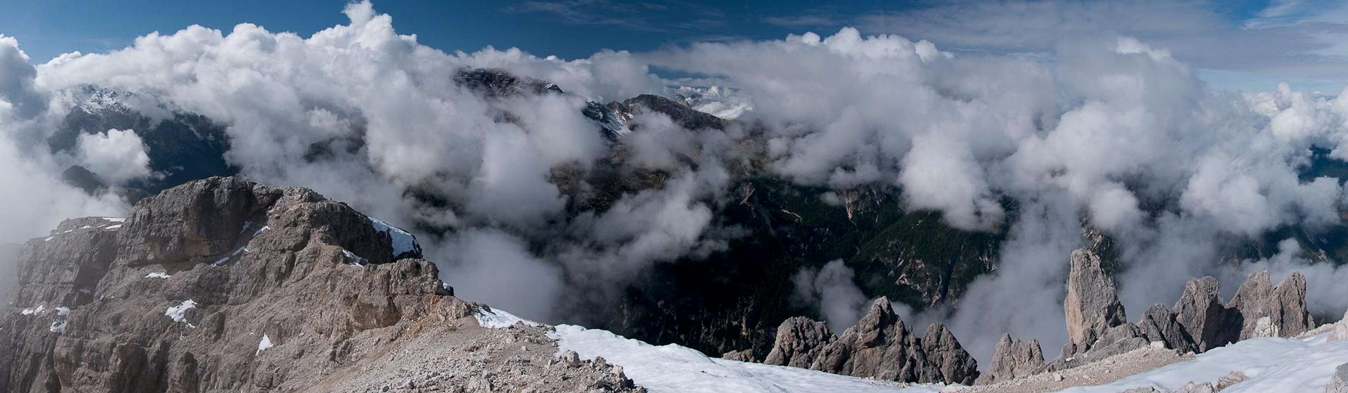
Dürrenstein summit panorama across the Prags / Braies Dolomites |
Though it is only 11 a.m. We decide to have lunch and start to unpack. Quickly the small summit fills up as more and more people appear across the crux section. Most seem to have problems but all finally make it. And – believe it or not – all of them are Germans. We kinda feel like home. I munch my lunch with the camera at my side, taking each chance when the clouds lift. With a bit of patience I can look across
Sarlriedel to
Lungkofel and
Sarlkofel, two summits we had climbed about a week before. However, the
Sexten / Sesto Dolomites, which we know are just across
Höhlensteintal / Valle di Landro remain invisible.
![South ridge]() Looking across the south ridge from the summit
Looking across the south ridge from the summit
Ever more hikers (still all Germans) reach the summit and we get a bit desperate and pack. Moreover the clouds seem to close in on
Dürrenstein with the patches of blue sky getting ever smaller. Soon we are back at the little crux and then start to hike down the ridge. From the first saddle we have a last (or first) view back to the cross and crowds on top while to the other side the southern pyramids make an appearance. More and more people appear on the slopes and we feel it is high time we left. Another view into the next saddle – even a bit of Sexten Dolomite Rock can be seen and down we go. At this point I lose track of the nationality of all those people on the slope. I'm still convinced all are Germans but wouldn't place a high bet anymore.
Weather starts turning for the worse and for most of the descent the scenery is hidden from view. I concentrate on flora and fauna for a bit, then look across towards
Roter Turm, a tower in the nort-west face of
Hohe Gaisl / Croda Rossa. Finally we make it below the cloud level and reach the upper reaches of
Plätzwiese / Prato Piatta. We walk across to the old WW I fort at its southern end where we take another break. But then – while we're still eating our apples – rain starts to fall in fat drops and we quickly pack up to go. After several hundred metres we have to put on our rain gear and for the remaining kilometre we rush back to the car. It is still early but we decide to return to the apartment and arrive there around 4 p.m.
![Plätzwiese / Prato Piatta]() Descending towards Plätzwiese / Prato Piatta
Descending towards Plätzwiese / Prato Piatta
Though we haven't seen much of the fabled
Dürrenstein views, we still are quite happy with the day. A summit in the bag, even an elusive one!
![Dürrenstein Hut and WW I Fort]() Dürrenstein Hut and the WW I fort at the southern end of Plätzwiese
Dürrenstein Hut and the WW I fort at the southern end of Plätzwiese![Dürrenstein Summit]() The Dürrenstein Summit
The Dürrenstein Summit


Comments
Post a Comment