May 18th 2013 – Getting Ready for Crete
![Agio Pnevma in front of Dikti]() The Agio Pnevma Chapel in front of Dikti The Agio Pnevma Chapel in front of Dikti |
After having spent a two week vacation in the east of
Crete in 2007 we knew that we would have to spend another vacation in the east of the island. With three mountain ranges at more than 2000m
Crete is the third highest island of the Mediterranean after
Sicily and
Corsica. In 2007 we stood on the highpoint,
Psiloritis, and on four mountains of the
Levka Ori, Crete’s White Mountains. The lowest of the 2000er ranges,
Oros Dikti, still was missing and since the guidebooks claimed it contained the remotest and most difficult of Crete’s mountains to go there was a must.
In the following years we picked eastern
Crete as a vacation destination more than once, only to be foiled by our inability to find a decent holiday home. This year it was different and so finally the second
Crete vacation was on. Booked in February we had almost forgotten about it but now we are ready and everything is packed. The flight will be at 5:20 tomorrow morning. We’ll celebrate the birthday of one of Judith’s sisters, taking all luggage with us. Upon returning we’ll check in at Frankfurt airport. Getting up at 3:15 will be hard but we’ll have a whole day on Crete before us when we’ll arrive at 9:35.
At the birthday party everybody is complaining about Germany’s never ending winter of 2013. April already was the darkest April on record and May will turn out to be the wettest May ever recorded. We feel we are lucky to escape the never-ending gloom and our relatives are fittingly envious. We discuss plans as four other people plan to go for a one week vacation to the Alps. Nobody is sure about snow conditions; even on
Crete you can encounter snow on the mountains up to June. But our prospects are much better with summer like temperatures at our destination,
Agios Nikolaos.
After supper we leave for the airport and check in the luggage. We’re ready to go now!
May 19th 2013 – A Shock!
![Kritsa Gorge]() The mouth of Kritsa Gorge
The mouth of Kritsa Gorge
3:15 alarm clock, a quick shower, taxi to the airport, security check, waiting at the gate, boarding, takeoff, breakfast, touchdown, rental car – now we are on our way to the vacation home. It’s only 10:30 but without the car’s AC we would already be helpless. It’s hot down here! After the one digit temperatures back home 36°C are almost too much for us. Driving on the Cretan highway is its own challenge. Two laned, the highway is used by up to four cars at a time and driving slow I have to file over to the support lane. After 45 minutes we are at
Agios Nikolaos and start the search for our holiday home. The village
Elinka is easily found but we drive by the house twice before we get out to ask somebody who points it out to us.
The small house is huge from the inside and has a large roof veranda. However, it is as hot inside as it is on the outside and unpacking is not much fun. During lunch we decide to go for one of the hikes in the vicinity, a scramble through
Kritsa Gorge, which is little more than 15 minutes away from our house.
We drive there and I manage to find a parking spot in the shade of an olive tree. This vacation is up to a good start! After a few minutes of hiking we get a glimpse of the gorge, with big limestone walls towering above the deep cut of the canyon. We descend towards the dry creekbed which comes out of the gorge and are greeted by Crete’s omnipresent oleander bushes. A few old carob trees cast a bit of shade and then we find ourselves at the mouth of the gorge. At first it is a level walk beneath the towering walls but quickly rocks require us to scramble through the canyon. There are very narrow washed out passages and we enjoy the hike, even in spite of the heat. After about an hour we head out of the narrow part and return, meeting a few couples on our way back. In the end this will turn out to be one of the most crowded days of the whole two weeks…
May 20th 2013 – A First Appointment with the Lasithi Plateau
![Afentis]() Afentis seen from the east
Afentis seen from the east
Deciding that visibility is yet too low to enjoy the 2000ers and that anyway one should get a slow start to one’s vacation we browse the guidebook for an alternative. We come up with
Afentis, a mountain to the west of the
Lasithi Plateau, 1578m high and reportedly with a wonderful view. The hike is a loop, ascending along the west ridge and descending through a valley. This appeals to us, especially since the night has been hot and during daytime it’s not bound to get cooler.
Up we drive – about an hour – until we reach the plateau. With 45 square kilometers it’s the largest of Crete’s high plains, intensively used for farming and surrounded by mountains on all sides. We cross it by car driving through three of the villages which are very busy. We park our car at the trailhead and even before setting out are surrounded by a large flock of sheep and goats which are driven to the meadows on the sides of the plateau. The first impression captivates – nice fields with lots of flowers. Then we follow a track which turns into a medieval trade road, which used to connect
Lasithi with the coast in the north. Today most of the road is broken into pieces and a landslide covers the topmost part of it.
![Summit panorama Afentis]() Summit Panorama Afentis: the Lasithi Plateau with the Dikti Range to the right
Summit Panorama Afentis: the Lasithi Plateau with the Dikti Range to the right
Finally we reach a saddle and a dirt road, which we follow in the direction of our destination:
Afentis. The sky turns hazy and we can barely see the coast. There are what seem to be summer homes beside the road and finally we reach a cut, where we leave it. We cross a pasture, then descend some limestone slabs to find ourselves in a beautiful little valley which we cross to ascend the far side. Here we hike up to the
Afentis east ridge where we find the ruins of a shepherd’s hut. We follow the steep but broad ridge snaking up to the summit. Here we find a radio station as well as a summit chapel.
Views are still hazy and there are a lot of bugs around. Falcons have taken the job of swallows chasing the bugs and adding to their diet. The
Dikti Range is barely visible through the haze but we know we’ll go there during the next weeks. For descent we first follow the maintenance road from the radio station, then switch to an overgrown path through abandoned fields in a valley. After endlessly climbing up and down the walls around the fields we reach
Plati Village from where we follow a road through the fields on the
Lasithi Plateau. We reach
Katho Metochi and head back to our car along the main road. Still the flocks of sheep and goats are around.
May 21st 2013 – Monastiraki to Thripti and back
Today we plan go to the isthmus and start hiking from
Monastiraki to
Thripti and maybe onwards to
Afentis Stavromenos. However, we soon find that distances and durations are too far and too long to get to the summit so we settle for a loop in the
Thripti Mountains. It’s still very hazy and hot – Sahara winds with lots of dust. The path traverses a slope and gets close to
Ha Canyon, a very impressive cut in the side of the
Thripti Mountains. Apart from a cave, a few orchids and a multitude of dragonflies there’s not much worth mentioning.
May 22nd 2013 – Plakokefala Ridge
![Plakokefala]() Plakokefala summit
Plakokefala summit is a long stretched mountain, which stretches above Crete’s Isthmus. It is broad backed but has some impressive limestone formations as summits. We hike from
Messeleri in the west of the mountain to an old monastery,
Panagia Vriomeni, where some hippie goats await us. Grouped around a source, most of the buildings are in ruins but the monastic enclosure is still intact. A small garden invites us to a short break.
We head onwards and wind our way among the limestone summits. Finally we get to the highest point with a radio antenna and a summit chapel. Ignoring the antenna we head for the chapel and take another rest. Suddenly some seven or eight griffon vultures make a majestic appearance. The huge birds patrol the summit for fifteen minutes, sometimes getting very close to us. After their disappearance we hike onwards for a bit, still winding our way among the summits. Near a source there is another ruin of a chapel and we take our lunchbreak there. We return the same way we came and reach
Messeleri completely dried up.
May 23rd 2013 – The First Half of the Dikti Traverse
![Crossing the Dikti Range]() Crossing the Dikti Range
Crossing the Dikti Range
A long drive takes us to
Selakano in the south of the island. The hamlet is one of the trailheads for the 2000ers of the
Dikti Range. Though we toy with the idea of climbing
Dikti today we are pretty sure that we’ll have to return from the saddle between
Dikti and
Afentis Christos. Time probably won’t allow. The final drive along the narrow mountain road to
Selakano is half an adventure by itself. The road is very narrow, rockfall prone limestone walls tower to both sides of the road.
Once in the village we hike out along the valley separating
Dikti from
Afentis Christos, a valley which will head up slowly but directly towards our destination saddle. It’s a hike rising gradually, traversing the northern slopes of the valley where some very impressive old oak trees offer some shade. It is still hazy and the sky is overcast most of the time.
The traverse takes forever. We have to realize we are only halfway up to our saddle when we reach the spot we thought to be our final destination. Instead we have to descend into one of the plateau-like hollows. A traverse and finally we ascend steeply to reach our saddle. Which itself is very broad and to find a decent lunchbreak spot takes quite a while. With the overcast skies and the time it took to get here we decide against climbing the last few hundred metres to
Dikti. After all it is supposed to be a difficult climb. Thus we return the way we came. Right before we reach
Selakano the clouds break open and reveal a dark blue sky. 90 minutes drive take us home…
May 24th 2013: The old Venetian Trade Road
![Louloudaki]() Louloudaki above the old Venetian Trade Road
Louloudaki above the old Venetian Trade Road
It is still hazy today and we once again decide against the 2000ers. Instead we drive to
Katsamonitsa to the north-west of the
Lasithi Plateau from where an old medieval trade road, built during the Venetian Era, climbs up to the plateau. Images in the guidebooks were impressive and it is always interesting to follow the footsteps of history. However, we get lost big time, so much that we hike a completely different tour than we had planned. We follow a dirt road and while waiting for the trade road to turn off to the south we hike on and on getting higher and higher up on our way to the
Lasithis Plain. After two hours I realize where this road is taking us, right to the spot where we left for Afentis on our third day on the island.
The wind seems to be changing as the haze starts to clear. This time we actually can make out the north coast during the many loops and switchbacks the road needs to head up to the plateau. At noontime we finally manage to reach our Venetian Road. We had been here before so that we find it easily from above. A lunch break with a view to
Lasithi and hovering above,
Lazaros and
Dikti.
As we descend towards the old road we have to realize that it is in ruins, no easy going indeed. The first few metres are difficult to find but after a while the road starts zigging back and zagging forth. Halfway down into the valley we leave for a second trade road, this one newer but in an even worse state of decay. Finally we are happy to reach the
Agios Georgios chapel at the base where we can take a break from the intense heat. A scorchingly hot return trip on a dirt road and we are back in
Katsamonitsa.
May 25th 2013: To the Top of the Dikti Range
![Dikti seen from Limnakarou Plateau]() Dikti seen from Limnakarou Plateau
Dikti seen from Limnakarou Plateau
Our guidebook claims it takes 10h for the ascent from
Lasithi to
Spathi / Dikti but also claims there is a rugged dirt road which one might drive to the
Limnakarou Plateau, which might shorten the ascent by 3h. Thus as we are driving through
Agios Georgios on the
Lasithi Plateau we are looking for this dirt road. In the end we decide on a dirt track and barely make it through the ruts only to find the actual road heads along a few hundred metres to the south. Actually the road is paved and we get to
Limnakarou much faster than we had anticipated. We park the car near the
Agio Pnevma Chapel where we have a good overview of the route. It follows a road / path to the end of the plateau from where a rocky creek bed like valley heads up to the south-west. Luckily there are markers for the
E4 trekking trail, otherwise orientation would be tough.
There is a second plateau high above
Limnakarou which we have to cross. Once we climb out of it we suddenly see
Psiloritis, Crete’s highest mountain, hovering above the plains in the west. The haze which marred views all last week is lingering way down above the plains but above 1500m skies are clear. Then there is
Afentis (we stood there on our third day on Crete) but we head southwards, where a view of the north face of
Afentis Christos awaits us. We turn left and suddenly find ourselves in the exact saddle we turned around two days ago.
This time there are no clouds above
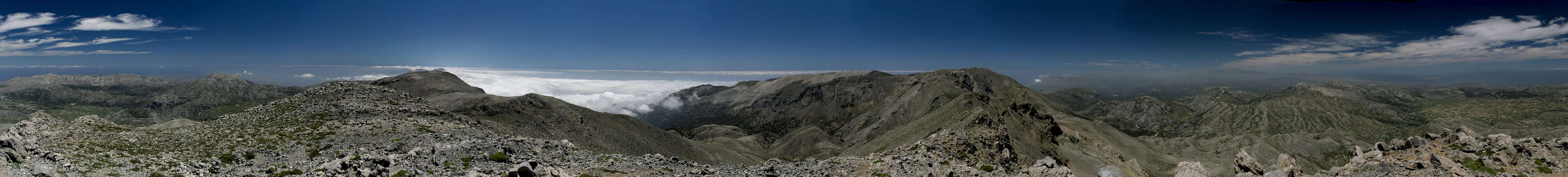
Dikti so that we march right through the saddle and head for the ascent path. It crosses the south slopes of the mountain on brittle terrain and thus circumvents the most difficult parts of the mountain’s west ridge. The slope gets steeper and right before the main summit we reach the ridge. A few steps and we find ourselves on top, taking in a perfect 360° panorama. After lunch, as we prepare to leave the summit, two griffon vultures soar by, only a few metres away. We descend the way we came, reaching the car as today’s summit lights up in perfect photo conditions.
360° summit panorama from Dikti |
May 26th 2013: Afentis Stavromenos
![Hiking through the Afentis Stavromenos North Face]() Hiking through the Afentis Stavromenos North Face
Hiking through the Afentis Stavromenos North Face
From our apartment we can see the
Thripti and
Oros Ranges and among them
Afentis Stavromenos takes the prominent place. During our hike to
Thripti several days ago we contemplated heading to its top but then decided that the overall elevation gain would be too much. So we head to the village by car now, using the narrow mountain road which we crossed several times a few days ago. However, farmers with their livestock of goats in their pickups are before us and it turns out to be a real slow drive.
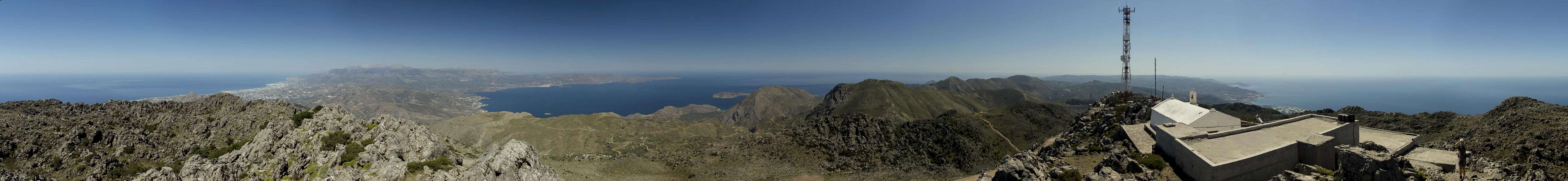
360° summit panorama from Afentis Stavromenos |
The path we take from Thripti is very steep and finally ends us in the north face of the mountain. The rock is brittle and we are happy as we head into a saddle, behind which we find a narrow plateau. Crossing the plateau we reach a dirt road which we follow to the top. I don’t mind summit chapels but here we also have radio antennas on the summit. The view, however, is wonderful, both sides of the island are visible and
Mirabello Gulf is worth seeing from up here. We decide to use the road for descent and are back at
Thripti a bit after noon already. But we return home anyway as it is blazingly hot this afternoon.
May 27th: Pefki Gorge
![Pefki Gorge]() Pefki Gorge
Pefki Gorge
It’s still hot today so we declare today gorge day and drive over to the south coast to
Makrigialos. We hike through olive plantations to
Agios Stefanos, take the road to
Pefki and head down through the gorge. But before we realize we’re out of it again, so short is it. Not much to remember of that day…
May 28th: Afentis Christos
![Afentis Christos / Αφέντης Χριστός]() Afentis Christos north face
Afentis Christos north face
Today we’re back in the
Dikti Range. The goal is to climb the second highest mountain of the range,
Afentis Christos. Trailhead and much of the route are the same as for
Dikti itself and this time we easily find the trailhead. Weather isn’t bad but hazy – it looks like there is a lot of Sahara Dust in the air again. As we reach the saddle, which separates the two mountains we run across a herd of sheep with their lambs and the vultures are back as well, circling above the flock. Suddenly we are assaulted by fierce winds and Judith talks of turning around. However, we soon get behind the east ridge which shades us from most of the attacks.
The guidebook claims that this is the most difficult climb in the east of Crete so we brace for difficult terrain. However, we realize that orientation is the biggest problem as you have to cross the karst slopes in the east of
Afentis Christos and there are only few signs and cairns to lead the way. Moreover the hike goes on forever, each time you see a summit you think it’s the final one but then you have to pass it and head for the next one. Finally there is the summit chapel and the storm awaits us. We are quite happy about the chapel as we can huddle down behind it and have our lunch.
Down we go, again losing our way several times, sometimes voluntarily, sometimes not. We hike a detour to one of the saddles between the false summits and enjoy a wonderful view down the north-west face of the mountain. It’s hazy, though, and far away views amount to nothing today. We return to the sheep, which appear to be nervous and as we turn the next corner we can see why: two vultures have landed right where the sheep used to stay this morning. But seeing us they take flight again and the sheep return to their sweet spot.
May 29th: Sandstoms in the Ornos Range
![Visibility in a Sahara Dust Sandstorm]() Visibility in a Sahara Dust Sandstorm
Visibility in a Sahara Dust Sandstorm
Over night it has gotten even hazier than it was yesterday. Also, stepping out of the house we are greeted by a big gust of wind. Car doors get slammed shut as we enter the car – another stormy day has arrived. We plan to hike through the Ornos Range, there is another canyon to explore and we figure that we are safer there than on the mountaintops. We reach
Kavousi and park our car. As we are getting ourselves ready a women leaves her house to come to us and warn us not to go in this weather. The gusts of wind confirm her but we thank her and attempt the route anyway.
As we get close to
Kavousi Gorge wind appears to die down, seemingly confirming our decision. But we have to climb an old mule trail to the side of the gorge and soon we get hit again. Judith with her lower weight gets pushed back and forth but we still head onwards. Every now and then we are peppered with sand and pebbles, asking ourselves why we came here in the first place.
The gorge widens and makes room for a valley. On the opposite another (the same?) gorge heads up between two mountains until it reaches a cut-like saddle. Very impressive from afar. Finally we reach
Melisses, a dead end village in a dead end valley. Taking a break near the chapel we realize that visibility has gotten lower still. The guidebook wants us to head onwards across a ridge towards the next village but in this visibility and storm we decide to rather head back.
Seeing a roundabout return road on the map we head for it, soon realizing that we’ll have to scale quite a lot of elevation until we will reach
Kavousi again. We take a dirt road up towards a saddle, still being peppered by pebbles and being tugged around in all directions. Right before the saddle I take a shot of the valley we came up from, which is barely visible through the dust anymore.
We reach the saddle and a violent gust of wind attacks us. We cover down behind a large boulder, trying to scout the route in front of us. A quick run of 200m and we are in front of a rock wall, where the wind appears to be lower. Instead rocks fall down from above and we keep up our quick gait. Each new turn of the road offers different conditions, none of them enjoyable. Finally, after a turn we reach the intersection with the path, which heads down to
Kavousi. We quickly head down for a few metres and soon the wind dies down around us while it still howls overhead.
We find ourselves in the ruined village
Tsamantis, where no house remains standing. Consulting the map we realize that we have to follow an abandoned irrigation channel out of this valley. We do and see that it leads to the mouth of
Mesona Gorge, which we had seen from the opposite side in the morning. The irrigation channel drops steeply into the gorge always accompanied by a maintenance trail. It just feels like a Madeira Levada. After the initial narrow section the channel remains (almost) level while the gorge drops away beneath us. The whole experience is very impressive and would be even more so if we were able to see the surrounding mountains.
![Azorias Olive Tree]() Azorias Olive Tree, 3250 - 3500 years old
Azorias Olive Tree, 3250 - 3500 years old
In the end we leave the gorge and have a break beside another small chapel. Finally we find ourselves beside the famous
Azorias Olive Tree, one of the oldest ones of the world. At an estimated 3250 - 3500 years of age it has a diameter of 5m and a circumference of more than 14m. The remainder is a hike on roads and paths through the olive plantations of
Kavousi.
May 30th: Moutsounas Toumba
![Summit view Moutsounas Toumba]() Summit view Moutsounas Toumba: Dikti and Afentis Christos
Summit view Moutsounas Toumba: Dikti and Afentis Christos
Over night the sandstorm has died down and we wake up to a clear day. We decide for a hike from the
Lasithi Plain towards the west. Early on we lose the trail and struggle through the macchia-like undergrowth between sheep pastures. We leave the valley and reach some ruined farm buildings where we take a break. Suddenly we realize a cloud of vultures right above the valley we just left. A flock of sheep is heading up the valley and obviously there are small lambs or ill animals among them. I count more than 30 vultures!
Now we head for the saddle at the end of the valley, then up to the next summit ahead. It is
Moutsoumas Toumbas (1538m) a broad backed limestone mountain above the Lasithi Plain. The skies have not cleared complately after yesterday’s sandstorm. The plains at sea level are still dusty while at our elevation you can see the mountains around. Even
Psiloritis is visible, though only barely. After lunch we return to the trailhead, this time remaining on the dirt road and skipping the bushwhack through the undergrowth.
May 31st: Mithi, Metaxochori and the Sarakinas Gorge
![Metaxochori Maltese Church and Graveyard]() Metaxochori Maltese Church and Graveyard
Metaxochori Maltese Church and Graveyard
Today we go to
Mithi. Two of the guidebook tours start here. One above, the other through
Sarakinas Gorge. First we hike towards the village of
Metacochori, always on the balcony above
Sarakinas Gorge. We hike underneath overhanging rock faces across an old mule trail, which in former times was the only connection between the two villages. It’s an easy hike but it’s scorchingly hot today and we are happy as we reach
Metaxochori a bit ahead of time. The village appears to be more or less abandoned but three of the four churches have been whitewashed recently. Still the old ruined Maltese church with its churchyard attracts most attention. We return the way we came.
From
Mithi we hike the road to the entry of
Sarakinas Gorge. Not much fun in this heat but there’s little else to be done. It turns out to be the most impressive canyon we’ve entered on Crete thus far. Vertical and overhanging walls almost touch each other high above our heads. Most of the time we can only see tiny stretches of the sky. There’s a bit of bouldering in between level sections but hand and footholds have been carved out of the stones. Once we’re through the narrow section we take a break in the shade before returning.
June 1st: From Mesa Lasithi to Katharo Tsivi
![Eastern Green Lizard (Lacerta media)]() Eastern Green Lizard (Lacerta media)
Eastern Green Lizard (Lacerta media)
Today we’re back on the
Lasithi Plateau. We hike from
Mesa Lasithi towards the east. Much of the hike runs along dirt roads with some narrow shortcuts in between. As usual on this island there are chapels every now and then and we run across the common flocks of sheep and goats. Finally we make an attempt on
Katharo Tsivi which offers nice views towards
Selena Oros and the
Mirabello Gulf. But today’s star is an eastern green lizard (Lacerta media), which dives down under a stone but later nosily takes a peep at us again. I take off the pol filter of my camera to take a shot, then forget it on the stone I placed it upon. We are almost back at our car when I realize and I have to run back 3km to retrieve €100 worth of optics.
June 2nd: Cape Agios Ioannis
![Mirabello Gulf]() Mirabello Gulf with Spinalonga Island
Mirabello Gulf with Spinalonga Island
We have half a day to spare as our flight back home is due only after 20:00h. So we decide to head for the immediate surroundings of our holiday home and hike to
Cape Agios Ioannis. It starts at
Plaka, one of the beach villages on
Mirabello Gulf. The old mule trail has been turned into a road since construction of new holiday homes is going on there. But soon the road ends and we have a beautiful hike with an ever increasing vista across the gulf with the island of
Spinalonga and its fortress. Once on top of the peninsula we follow a dirt road for a while but then our hiking trail turns off. It runs through the steep cliffs of the island, panoramic but also overgrown with thistles and worse stuff. The path somehow runs out in the middle of nowhere and we bushwhack through all those thorny bushes to a dirt road underneath.
The road takes us to the chapel
Agios Ioannis, the naming patron of the cape. It is located 200m above sea level amidst some dozen windmills. We have our lunch there but then decide to head on- and downwards to the old lighthouse at the very end of the peninsula. However, we don’t find the correct path (it later turns out to be a broad road) and explore the edges of the plateau until we find something like a ledge to go down on. Soon we are at sea level heading towards the tip. The lighthouse is in ruins and we don’t dare to enter it. Returning on the other side of the peninsula we head back to our car.
The remainder of the day is uneventful. We pack, shower, drive back to the airport, queue several times for car, check-in, Security check, take our seats in the plane, fly back, take the taxi and are at home at 1 in the morning. Next day everybody complains about the bad weather they had in Germany during the last week and nobody wants to believe we had to sweat at 36° C. But this is bound to change next week when German weather starts to soar and get close to the 40°C mark.
Comments
No comments posted yet.


 The Agio Pnevma Chapel in front of Dikti