After a week of exploring Sierra de Guadarrama, which is covered in the first part we had understood the geography of the range by hiking in almost all of its part. The centre, Siete Picos was still missing but we had no intention of missing it. We'd seen a lot of the range's flora and fauna but more was yet to come. We didn't know we were to meet some of Europe's rarest animals up close.
What we knew, however, was that we had to brace for an incredibly hot week. Temperatures had been hovering about the 30° C range but the forcasts called for cloudless skies with temperatures up to 38° C. We knew we had to escape to areas above 2000m otherwise we would dry up from inside. Stocking up on table water we prepared to be slowly cooked.
June 11th – Montes Carpetanos
Valle de Loyoza seen during the ascent to Alto del Puerto
Since the weather forecast called for hot temperatures we decided to once again head above 2000m. But since we expected crowds on the most interesting peaks on a Sunday we decided to go a little farther away. We decided to climb Pico del Nevero from Puerto de Navafria and then see whether we couldn’t bag a few more summits on the Montes Carpetanos ridge between Nevero and Peñalara. This, however, meant a long drive across Puerto de Navacerrada and Puerto de los Cotos and through the upper Valle de Lozoya. It was fast enough in the early morning hours but upon returning home we realized that the valley is extremely popular with the picnicking crowd.
There was only one car in the small parking lot in Puerto de Navafria when we reached it, so that our strategy seemed to work well. It was already hot though it was only a little after 9 a.m. as we headed out westward from the pass. The first 2 km are a straight hike in the fall line of Alto del Puerto, the first summit, and much of it runs through a dense forest. Unfortunately for us we stirred up gazillions of flies wich together with the heat were really annoying.
Alto del Puerto
Peñalara
Nevero
Once out of the forest the flies left us alone and we closed in on the south-east shoulder of Alto del Puerto. The mountain is already more than 2000m high (2095m) and has a quite impressive south face. We hiked up the shoulder and the higher we got the better we could look into this dramatic face. We were to learn later that this is a feature of any of the summits of the Montes Carpetanos in this area. The faces might point in different directions but they all are rather impressive.
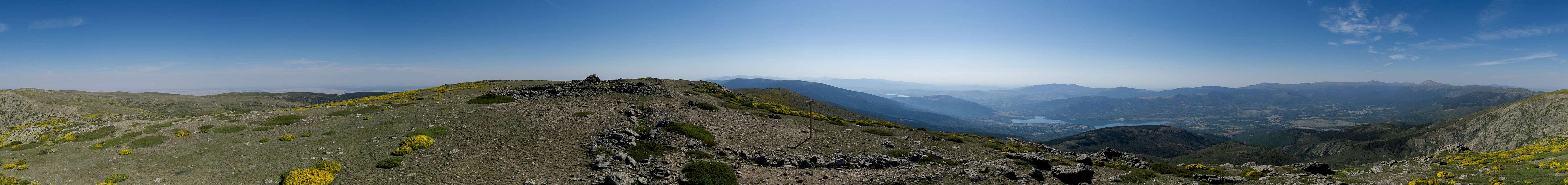
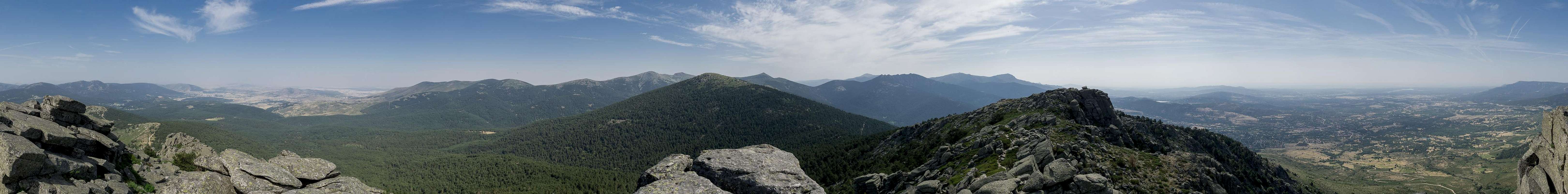
360° summit panorama from Pico del Nevero
We didn’t rest on Alto del Puerto but hiked on towards Pico del Nevero (2209m). It has the same kind of south face but the top is almost flat and without the summit pillar you wourdn’t know the exact spot. I climbed up onto the pillar to take a 360° panorama and a more detailed look around. The next mountain to the west, Alto de Porrinoso (2170m), seemed easy enough to hike to and further on, Peñacabra (2160m) also looked doable before we would run out of time.
Vipera latastei
Peñalara with cow poser
Vipera latastei
We headed down into the saddle between Nevero and Porrinoso where a handful of cows were grazing. To manage this we had to negotiate the omnipresent broom bushes which in some places stood so close to bar the way. Finally we reached the end of the broom field and as we closed in on the saddle we ran across a snub-nosed viper sunning directly on our path. It stayed still for minutes which gave me to opportunity for some dramatic close-up shots.
Peñacabra
We followed the edge of the south-east face of Alto de Porrinoso to reach its summit without any effort or any more drama. Looking west towards Mujer Muerta we saw another summit pillar close by and decided to go there as well. Getting there was easy enough but any step further towards our next goal, Peñacabra, was blocked by broom bushes. We had to bushwhack our way through the yellow sea until we finally reached something which looked like a path. It led around two large couloirs before heading out on the meadow like north-west slope of Peñacabra. A few more steps, again following the edge of the Peñacabra south-west and south faces took us to the top.
Alto del Porrinoso
Cinereous vulture
Montes Carpetanos
Lunchtime beckoned and while we rested and took in the scenery several vultures soared overhead, no doubt attracted by a flock of cows which was grazing vertical beneath us at the foot of the Peñacabra south face. First several griffon vultures flew by but then the dark shape of a large cinereous vulture appeared. At a wingspan of up to almost 3m they are among the largest birds of prey in Europe. This one was huge and we could observe it for a while since it did two turns above the cows and us.
Alto del Puerto south face
Finally we packed our things and started the return hike. It took us all the way back across Alto de Porrinoso, Pico del Nevero and Alto del Puerto. We now met several hiking groups but somehow managed to go clear of them for most of the time. Luckily, when we dived down into the forest beyond Alto del Puerto the flies had become too lazy in the afternoon heat which had become intense so that we could reach our car without any annoying problems. The drive back took long as we had to get through Valle de Lozoya where narrow roads had been turned even narrower by parking cars with others cruising to get a parking space. We returned home rather late that day.
June 12th – La Pedriza again
Weather was bound to get hotter and hotter up to the day we would leave. And though we weren’t exactly running out of high routes we also wanted to do a second tour of La Pedriza. So I suggested this tour even though we knew we would be parched by the time we’d return. The plan was to hike the western part of the little range up to Collado del Mirradero and decide there about further proceedings. We had an idea we would go to the eastern part of Pedriza Posterior and hoped the rock formations would be as impressive as the ones we had seen during our first loop a week ago.
Rock formation
Steep couloir
Griffon Vulture
Heading out from Canto Cochino we first were a bit disappointed as we had to hike through a dense forest with few rocks to see. As it was still very early we had we had many spiders webs to hike though which somehow took the fun out of hiking. Finally a line of rocks barred our way – the first ones we actually could see. The trail headed for a gap between two of the highest rocks and it turned out we had to climb a steep couloir in order to get there.
Rock formation
A dog's head
Collado de la Canaleja
Our efforts were overseen by a griffon vulture which perched on the western of the two rocks, very close to our route but still looking unimpressed. Once in the saddle it turned out that the eastern rock was “inhabited” as well and we wondered if the birds were looking for fallen hikers in this area. A second rock barrier loomed ahead and we prepared to negotiate it as well.
Ledgeways
Portilla de Tres Cestos
Watchtower
It turned out to be much easier as the terrain now was more open. We hiked though a wide saddle with a view of the rocks to come but then turned to the east of the summits quickly losing elevation. The track wound through the eastern slopes until – quite suddenly – it turned left and headed up into another saddle. There the trail seemed to end but after a more detailed search we realized it headed up onto a ledge which cut through a large granite face.
Cuerda Larga seen from Portilla de Tres Cestos
Climbing was a bit precarious here – smooth rock, no protection – but we finally got up to one of the rocks, where we had a very good vista towards the southern part of La Pedriza with a rock window up close enhancing the view. Also the watchtower above Portilla de Tres Cestos, our next destination, was only a stone throw away.
Rock Dome
Right leaning towers
Griffon vultures
After several ups and downs we were in the Portilla gazing up at the watchtower. Beyond we got to the outside of La Pedriza, negotiating ledges high above the topmost Valle de Rio Manzanares. We had quite a lot of rock hopping to do but always with good views towards the western part of Cuerda Larga. Finally we reached Collado del Miradero where we prepared for lunch on the lower slopes of Peña del Rayo. There are quite number of almost white smaller towers in the saddle and I explored them a bit while we stayed there.
Fine spires
Knobbly tower
Rock traverse
Now we needed to decide how to proceed and decided on a path which would take us along the outside of Las Torres before diving into the maze of Pedriza Posterior. We wanted to hike to Collado de la Ventana and then follow a steep but hopefully marked trail through the valley of Arroyo de la Ventana which would take us to La Autopista and back to the car.
Rock Tower
Lady La 'Za
Rock tower
So off we went, still on the outside of La Pedriza. We passed the five Torres and got real close to Peñas Linderas, which we had visited two days ago. As we walked by, griffon vultures soared above us while a couple of female ibexes came down from the third Torre. We finally got to the gateway into the maze and immediately were greeted by towers to the right and left. We walked across a small plateau between the towers where another ibex lady posed for us. Below we could see two griffon vultures as well as a cinereous vulture on their perches. As we hiked towards them they took flight leaving only the rocks for us to admire.
Warning fingers
L'Esphinge
Arroyo del Ventoso
And there were many of these – left leaning ones, right leaning ones and the occasional straight one. With every corner we turned views got more and more amazing. We were back in the maze and luckily there were cairns to guide us. We walked by a small flock of lady ibexes, one of them struggling to strike the perfect pose. Which she finally did, directly between two of the highest towers here. On and down we went, mouths ajar. The formations got weirder and weirder, the spires narrower and narrower. Close to Collado de la Ventana we walked around L’Esphinge, the Sphinx, a huge rock somehow resembling the Egyptian counterpart in Gizeh.
Arroyo del Ventoso
El Puro
Vultures and domes
Finally we reached the collado, from where we hiked down the gully-like entry to Arroyo de la Ventana. To the left we passed El Puro – the cigar, a fine narrow spire. We passed through the saddle by its side and got to a larger rock-strewn plateau, where we started looking for the exit. After two false starts again we stood above a gully which led steeply down into the lower valley of Arroyo de la Ventana. Unfortunately here the ground was loose and hiking was far from comfortable. In the arroyo we had to do some rock-hopping down cascading rocks before finally the path switched over into the forest to the left to lead down into the central valley. Here we joined the autopista hiking track and quickly got back to Canto Cochino and our car.
June 13th 2017 – Cuerda Larga, Western Part
Cerro de Valdemartin
It was even hotter today so we had to go as high as possible to flee the heat. We decided to hike from Puerto de los Cotos towards Bola del Mundo and from there onwards to the Cabezas del Hierro. In all, we stood on four summits, some of them twice. Also this turned out to be the longest hike we did in this vacation, mainly because we underestimated the hike-in from the Puerto.
Bola del Mundo
Siete Picos
Peñalara
The first kilometer was quite annoying as we had to hike through a forest and – similar as when we hiked to Pico del Nevero – we get pestered by flies. But again, the flies vanished, as we headed out in the open and onto a ridge which would finally take us to Bola del Mundo. Now this mountain is the worst sight you can imagine in a mountain range: crowned by several rocket-shaped antennae it also is the largest ski area in Sierra de Guadarrama so that a multitude of ski lifts go up to its summit as well as to the one of neighbouring Cerro de Valdemartin. From where we were hiking we had the perfect view of this ski circus – minus the snow. And this always makes for a horrible sight.
Bola del Mundo summit rocketships
The flat ridge gradually rose and as it got closer to Bola del Mundo it got steeper. In the end it turned out to be real steep – like a good ski run should - and we got to one of the highest chairlifts of the circus. Turning west we headed for the summit of the Bola – which is off limits due to the radio and radar installations on top. Though ugly in general, in the lighting conditions we had with deep blue sky and bright white clouds the towers somehow looked attractive. Almost like lighthouses on some rocky shore.
Cow poser
Cuerda Larga
Cabezas del Hierro
A 360° vista was impossible without some serious interference by the lighthouse towers but nevertheless – views were great on all sides. We walked around the perimeter of the buildings before returning to the ski lift station we came from. There we took a path on the outside of the ski circus which took us to Collado de los Guarramillas where yet another cow posed in front of La Maliciosa. We then hiked along a snow-drift fence on to Cerro de Valdemartin (2276), another good lookout – this time with 360° possibilities.
Mr. Cool
Get Up!
Walk around
We stayed on track, heading down to the next saddle, Collado de Valdemartin from where a yello boom brush ascent took us to the upper slopes of Cabeza de Hierro Menor. Even from the collado we could see movement up there on the upper slopes and as we closed in, we saw a herd of male Gredos Ibex, resting on one of the rock outcrops. Tiptoeing around them I took some pictures but I realized that anything short of a fireworks display was too uninteresting to impress the blokes. In the end one of them stood up, turned around on his back heels – and lay down again. It felt arrogant …
La Maliciosa
Rocky descent
La Pedriza
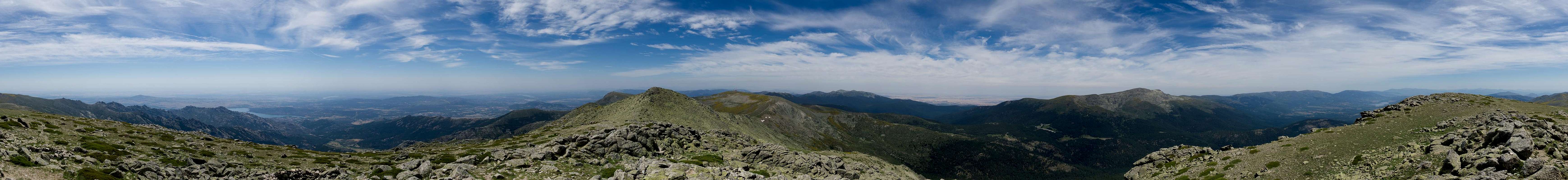
Ignoring the lack of impression we were able to make we scrambled up to the top of Cabeza de Hierro Menor (2376m), where another 360° panorama was waiting to be taken. A surprisingly rocky traverse took us into the Collado de Entrecabezas from where an easy hike led to the higher Cabeza de Hierro Mayor (2381m). Finally it was time for lunch!
360° summit panorama from Cabeza del Hierro Mayor
Afterwards we returned, skipping the very summit of Cabeza de Hierro Menor by 15m before returning to the arrogant blokes on their rock. They hadn’t moved – at least not significantly – but luckily some of their younger brothers were curious enough to actually move towards us. But maybe it was only one of them, if I interpret the astonished look of its relative correctly. After Collado de Valdemartin it was back onto Cerro de Valdemartin, down to Collado de Guarramillas and back to Bola del Mundo.
All the way back!
Peñalara
Young Ibexes
Here we took another break a bit to the side, away from the antennae, contemplating the final ridge traverse back to our car in Puerto de los Cotos. On the upside it was only down now but unfortunately the ridge was very long and we were running out of time. So we hurried along the long ridge, overtaking several groups and finally made it back to the car. A very long day indeed!
June 14th – Siete Picos
The crest of Siete Picos seen from Pico Sexto
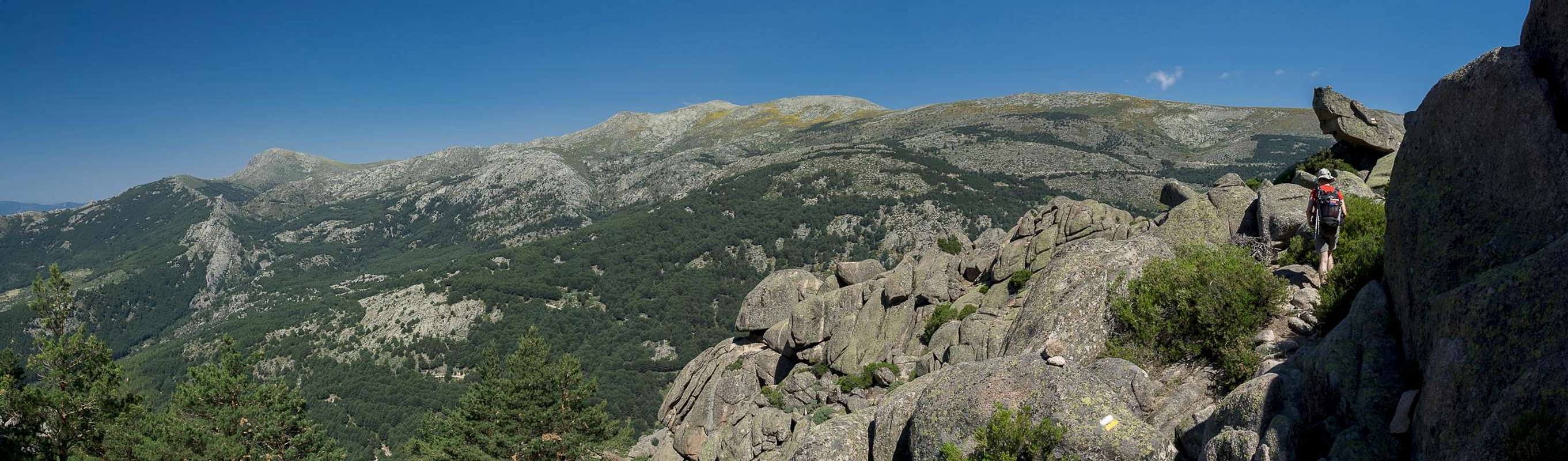
Like La Pedriza, Siete Picos were a must do and we decided to go there starting from Puerto de Navacerrada. The seven peaks, numbered from west to east would be hiked in reverse order with the hope of climbing some of them. We would then somehow return by Camino Schmid, a famed promenade in the area. Siete Picos are seven granite peaks, aligned on a west-to-east running ridge between Puerto de Navacerrada and Puerto de Fuenfria. It is somehow the central part of Sierra de Guadarrama, as it connects with all of the other subranges which all end in either of the two passes.
Puerto de Navacerrada is an important road pass. The associated resort is the centre of the Guadarrama Ski Circus which focusses on the runs around Bola del Mundo and Cerro de Valdemartin as well as the ones on Alto de Telegrafo east of Puerto de Navacerrada. And this was the exact route we intended to take.
La Mujer Muerta
Madonna holding the moon
Pico Septimo
We started in the huge parking lot on the pass and hiked to the ski run. Though it was closed we entered the ski run itself and scrambled upwards to the base of Alto del Telegrafo. After a short flat section we headed through the north face of the summit block to reach the top. Not much to see there but a Madonna statue carrying the moon and the outlook over the next stage of our route towards Peña Hueca, another low summit before the actual upswing towards Siete Picos.
Siete Picos Crest
Balancing rock
Pico Quinto
A steep meandering path then led through a pine forest towards the proper ridge of Siete Picos, which we gained at its easternmost end . Here we climbed up to the last of the peaks, Pico Septimo, wehhere the remainder of the seven became fully visible in front of la Mujer Muerta. Shot a hero shot, climbed down and went on to Pico Sexto, of which we climbed the north summit. A false start, retraced steps than along the northern side to Pico Quinto.
Pico Quinto
Pico Quarto
Pico de Majalasna
We skipped this, again passing by on the northern side from were a longer traverse led to Pico Quarto. Which we also passed to the north, just as we did with Pico Tercero. Then we switched to the south side where the path steeply headed down along the south face of Pico Segundo. Lots of pine forest to hike through before we stood in one more saddle.
360° summit panorama from Pico Majalasna
In front of us we had Pico Primero, also known as Pico de Majalasna (1932m) a bigger bulk of granite blocks. We climbed an interesting route first to its side summit, than across a gap towards the main one. It was a bit exposed but not difficult. It was still too early to rest so that we decided to proceed. From the summit we could see Cerro Ventoso (1965m) in the north and we decided to traverse it.
Pico Segundo
Montón del Trigo
Siete Picos
So we got off from Pico de Majalasna and hiked a surprisingly rocky path to Collado Ventoso, from where a short ascent led to the flat topped summit of Cerro Ventoso. After lunch we scrambled down the west side to Puerto de Fuenfria and along Senda de los Cospes and Camino Schmid back to Puerto de Navacerrada. In the pine forest there was little to see but still this turned out to be the most crowded hiking section of the whole vacation.
June 15th - La Peñota and Peña el Águila
Peña el Aguila, La Peñota
On the third day we had intended to start a hike from Puerto de Guadarrama (or Alto de León), which cuts through the southern part of Sierra de Guadarrama. Beneath it there is the Guadarrama Motorway Tunnel and Alto de Leòn is a busy road pass. So when we arrived there today were were not overly amused. We decided to hike the northern part of the ridge, leaving the southern one for the last day. Today we intended to climb La Peñota and Peña el Águila, both advertised by our guidebook with three routes each. Also, views were supposed to be excellent.
Civil war bunker
Peña del Archipreste
Civil war lookout
But before we got there we first had to negotiate a long almost featureless part of the ridge, which turned out to be rather ugly, especially in the part near our trailhead. The ridge saw heavy fighting during the Spanish Civil War and you can see quite a number of fortifications there. It actually feels a bit like the WW I trenches in the Dolomites. Even worse, several power lines run across Alto de Leòn and a lot of trees had been felled to make room for them.
Sharp beaked rock
Rock tower
Rock face
The first sight was Peña del Archipreste, a rock formation said to resemble a rider on its horse. From the side we looked upon it you need quite a bit of fantasy to see the ride but I’m sure from the other side it would have been more obvious. There was barbed wire there, though. A reminder of former times? Anyway, the next stage led us up to our first summit Cerro de Matalafuente (1673m), to the side of which we found yet another civil war fortification.
Saddle view
Ledgeways
La Peñota summit
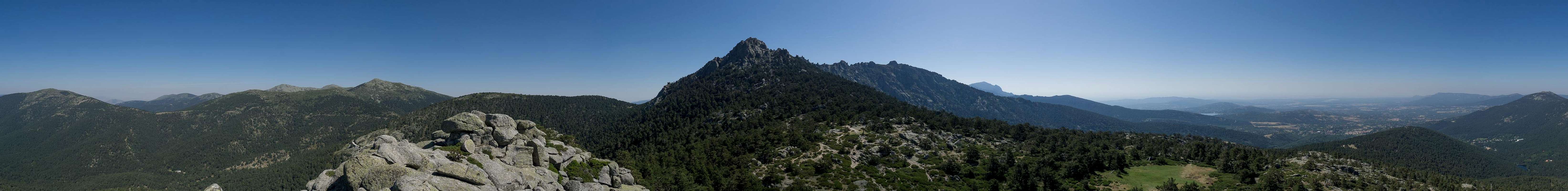
The next summit, Peña del Cuervo, barely made an impression and we soon stood at the base of La Peñota (1944m). This is a surprisingly rocky mountain and the hike turned out to be one of the most beautiful in the area. You hike on ledges, through exposed saddles and over rocks overgrown with blooming bushes – a real treat! Pictures hardly tell the story. We ended up on the main summit, took a bit of a break, then headed for the side summit. Here Judith told me she wouldn’t be able to hike to Peña el Águila (2161m) since it was far too hot for her. A bit disappointedly I managed to extend the route to Collado de Mostajo, where we had lunch in the shade of some pine trees.
360° summit panorama from La Peñota
Here we decided to split up. I went for Peña el Águila, while Judith stayed a little longer and then intended to climb slowly back to La Peñota where we would meet again. So I hurried up the overgrown south slopes of Peña el Águila, crashing through bushes on the way. I reached the broad summit plateau after some 20 minutes, took some hasty photos, then crashed back again. When I joined Judith on La Peñota I was dripping wet and needed a long rest.
La Mujer Muerta seen from Peña el Aguila
We returned along the beautiful path to the base of La Peñota and prepared for the return hike to Alto de Leòn. We didn’t expect much but were utterly wrong. The main event was yet to follow. On Cerro de Matalafuente we saw a Cinereous Vulture perching some 20m beside the path. I grabbed Judith’s camera which has a 480mm zoom lens, and tiptoed closer. The huge bird watched me warily but stayed put. Finally it unfolded its huge wings and with a rustling swoosh it dropped from its perch. Within seconds it was soaring far above us without flapping its wings more than twice. A very impressing encounter! (see signature picture on top)
June 16th (last day) – Cabeza Lijar, Cerro de la Salamanca, Cerro Carrasqueta
Cueva Valiente seen from Cabeza Lijar
Again starting from Alto de Leòn, we headed in the opposite direction from yesterday. The immediate surroundings looked better even though there were a number of houses – as well as civil war bunkers and a radio installation there. Still, after some 500m we left the dirt road and entered a hiking path which led us to Cerro Piñanero, a flat topped summit with trees on all sides but the south. We hiked across the summit plateau, then down the west slopes and suddenly stood in a saddle, where we met a couple of cows which appeared to have left their fenced pasture.
Rocks en route
Cabeza Lijar
Refugio de la Salamanca
It was not for us to decide what to do with them and so we tackled the climb to Cabeza Lijar. It headed along the east face of the mountain winding through a number of quite interesting rock formations. On top we found a paved summit platform and a wonderful view in perfect weather. Also it seemed to be butterfly day as many different ones are flitting across the flowers near the top.
Risco de Pollanco
Risco de Pollanco
Risco de Pollanco
Heading down and west from Cabeza Lijar was easy but beyond Collado de la Mina going got rough – at least for someone as tall as myself. The path headed through a tree covered trench and I had to bend forward all the way up to Refugio de la Salamanca. This was – again – a ruined building which today was kind of flash mobbed by a flock of horses. We waved hello and headed for the summit of Cerro de la Salamanca directly. A similar (to Cabeza Lijar) panorama awaited us.
Rock roses
Cerro de Carrasqueta
Descent from Cerro de la Salamanca
We spent little time up there and instead descended in the direction of Risco de Pollanco, which we passed on its eastern side. There are beautiful rocks there and a stretch in which you wade through a bed of white rock roses. Quite wonderful indeed! Descending further we quickly stood at the base of Cerro Carrasqueta, which we climbed to spend lunchtime on this well-known summit for the second time.
Parnassus apollo
Returning, I found the main event of the day awaiting us (or me) in form of an animal. This time it was an Apollo – one of the rarest, but most beautiful butterflies of Europe. I shot a whole series of photos, luckily getting a number of decent ones. Feeling happy I returned to Cerro de la Salamanca, where we were greeted back by our flock of horses. We decided to forgo the trech which meant scrambling down from high rocks in the central section of the descent. We then moved back to Cabeza Lijar, where we took our last break. I spent some time hunting down even more but more regular butterflies. Afterwards not much happened and we rather quickly returned to Alto de León.
Conclusion
Sierra de Guadarrama seen from Cabeza Lijar
We found Sierra de Guadarrama an easy but nevertheless wonderful location for a two week vacation. Its proximity to Madrid ensures quick access and even an option for enjoying some culture. La Pedriza is absolutely stunning. The higher mountains with their round tops might look boring but in early summer they glisten and gleam with myriads of brightly yellow blooms of Spanish Broom. What struck me most, however, was the “amount of nature” you can find this close to a metropolis. We saw three of the rarest animals of Europe, cinereous vultures, a snub nosed viper and an Apollo in the range as well as lots of ibexes, griffon vultures and more common butterflies. It’s a great place to be a great place for recreation for the inhabitants of Madrid. Let’s hope it stays that way!
Parents refers to a larger category under which an object falls. For example, theAconcagua mountain page has the 'Aconcagua Group' and the 'Seven Summits' asparents and is a parent itself to many routes, photos, and Trip Reports.


 La Pedriza Posterior
 Alto del Puerto
 Peñalara
 Nevero
 Vipera latastei
 Peñalara with cow poser
 Vipera latastei
 Alto del Porrinoso
 Cinereous vulture
 Montes Carpetanos
 Rock formation
 Steep couloir
 Griffon Vulture
 Rock formation
 A dog's head
 Collado de la Canaleja
 Ledgeways
 Portilla de Tres Cestos
 Watchtower
 Rock Dome
 Right leaning towers
 Griffon vultures
 Fine spires
 Knobbly tower
 Rock traverse
 Rock Tower
 Lady La 'Za
 Rock tower
 Warning fingers
 L'Esphinge
 Arroyo del Ventoso
 Arroyo del Ventoso
 El Puro
 Vultures and domes
 Bola del Mundo
 Siete Picos
 Peñalara
 Cow poser
 Cuerda Larga
 Cabezas del Hierro
 Mr. Cool
 Get Up!
 Walk around
 La Maliciosa
 Rocky descent
 La Pedriza
 All the way back!
 Peñalara
 Young Ibexes
 La Mujer Muerta
 Madonna holding the moon
 Pico Septimo
 Siete Picos Crest
 Balancing rock
 Pico Quinto
 Pico Quinto
 Pico Quarto
 Pico de Majalasna
 Pico Segundo
 Montón del Trigo
 Siete Picos
 Civil war bunker
 Peña del Archipreste
 Civil war lookout
 Sharp beaked rock
 Rock tower
 Rock face
 Saddle view
 Ledgeways
 La Peñota summit
 Rocks en route
 Cabeza Lijar
 Refugio de la Salamanca
 Risco de Pollanco
 Risco de Pollanco
 Risco de Pollanco
 Rock roses
 Cerro de Carrasqueta
 Descent from Cerro de la Salamanca