
Comments
No comments posted yet.
|
|
Trip Report |
|---|---|
|
|
57.16631°N / 5.0687°W |
|
|
Jul 13, 2023 |
|
|
Hiking, Mountaineering |
|
|
Summer |
Carn Ghluasaid (957m), Sgurr nan Conbhairean (1109m), Sail Chaorainn (1002m)
The three Munros that sit on the north side of Loch Cluanie above Glen Shiel are linked by proximity and the fact that they all sit along a connecting ridge which runs from the loch, around 7 kilometers north, into Glen Affric and throws out arms east and west into the surrounding wilderness.
According to the guidebooks, they are usually climbed together in one day and I have some history in attempting to accomplish this. In fact, it has taken me three attempts to climb all three main summits!
Kevin, Pip, Sue, Gill, Keith and I set out on a day of mixed weather, to climb the three Munros. We had a week with quite a bit of snow on the hills but not always settled weather.
The early sunshine in the morning, soon vanished as thick cloud blew in and covered us. We reached Carn Ghluasaid (Pronounced: Carn Voor – setch) and it started to snow.
We continued towards our next objective for a while in very poor visibility but eventually decided that descent was the better part of valour!
Nearly 21 years had passed but once again, I found myself in the car, staring out at the pouring, freezing rain which was washing away the existing snow.
Nevertheless, Kevin (again), Marie and I set out (Marie and I more reluctantly in the rain!) on the same route up Carn Ghluasaid. It was cold and unpleasant in the heavy rain and I really didn’t think we would get very far.
After about an hour, the rain stopped and was replaced by broken cloud and a strong wind. We reached Carn Ghluasaid again in reasonable weather and continued onwards.
As we climbed higher and passed over the “top” of Creag a’ Chaorainn, it got colder and the wind got stronger. The ground between this minor “top” and the main summit was very bleak. At one point, we were being battered by the wind and were in danger of being blown over. We staggered on until we eventually reached the summit of Sgurr nan Conbhairean.
Sail Chaorainn was further north along the ridge and none of us had done it before so, after a bit of a discussion, again we decided to call it a day, missing out Sail Chaorainn.
I knew that one day I would probably return again!
More than 11 more years had passed, Marie and I were driving up the valley from Glen Shiel, hoping that the rain and cloud might clear somewhere. The forecast didn’t predict it but we were fed up with staying indoors so, we hoped for the best. I had a few options in my mind but really wanted to try to reach Sail Chaorainn at some point on this trip.
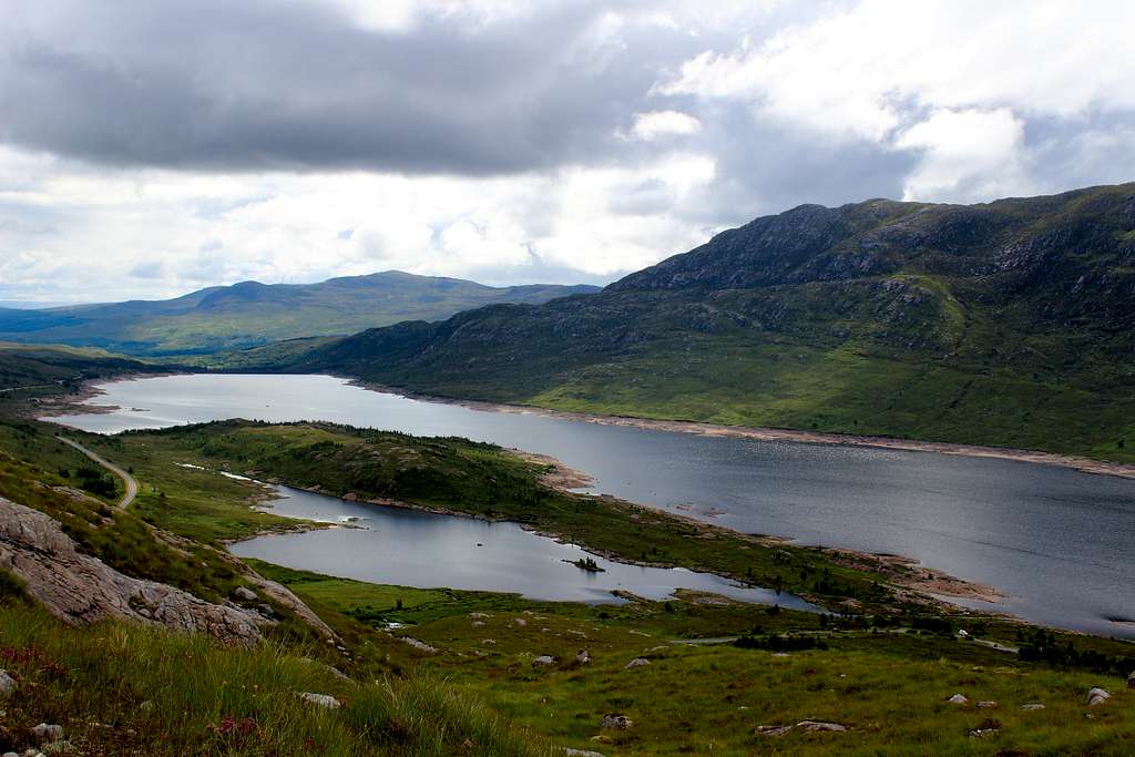
As we reached the Cluanie Inn, the sky brightened and some of the surrounding mountain ridges emerged from the clouds. The rain had stopped so we headed for the ruin marked as “Lundie” on the map, where we knew we could park.
It was the 13th day of the month and the 13th day of our holiday but I hoped it would be 3rd time lucky!
The car park area was full so we found somewhere down the road – consequently, I thought the mountain would be crowded. Actually, we only saw one group of 4 people all day!
We set out at 10.30 am, found the remains of the old military road and followed it westwards over the hillside, it was quite a warm start to the day although, it was very wet underfoot. It’s hard to believe that this track was originally made by an invading, English army.
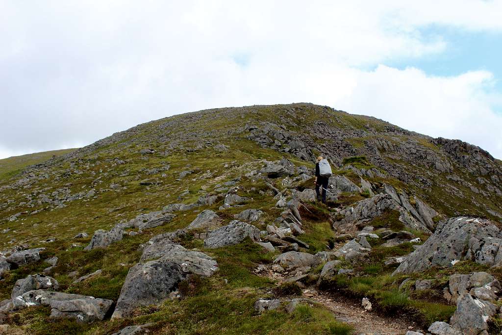
We followed the old military road, parallel to the new road for a while before, the obvious mountain path led us northwards, up the southwest ridge of Carn Ghluasaid. Things were going well as we made quite good time in the mix of cloud and occasional sunshine.
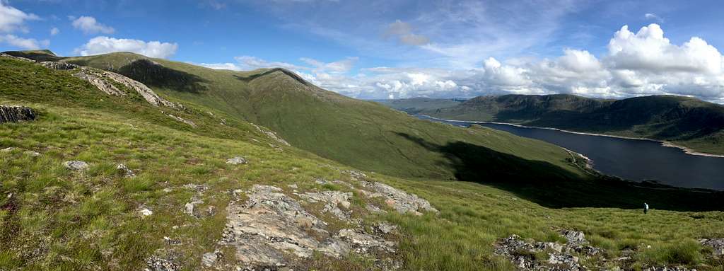
The path was easy to follow and the clearer weather gave us views over Loch Cluanie and to some of the nearby mountains.
We had finished the steep climbing up the southwest ridge when, looking back west, we saw a wall of rain, sweeping up the valley towards us. We quickened our pace to try to outrun it and for a while, I thought we might do it but soon we had to put waterproofs on as it reached us.
We sat for a while on rocks in the pouring rain and I started to think that perhaps our earlier optimism had been too good to be true!
However, it wasn’t too long before the rain eased a little and we set off again for the summit.
We reached it around 12.30 pm and stayed only a few minutes as it was cold in the rain.
I wondered about descending but Marie was keen to push on, so this we did.
As the rain eased off, we stopped for a cup of tea at a sheltered spot, then continued upwards again towards Creag a’ Chaorainn – the Munro “top” above the large eastern facing corrie - in misty conditions.
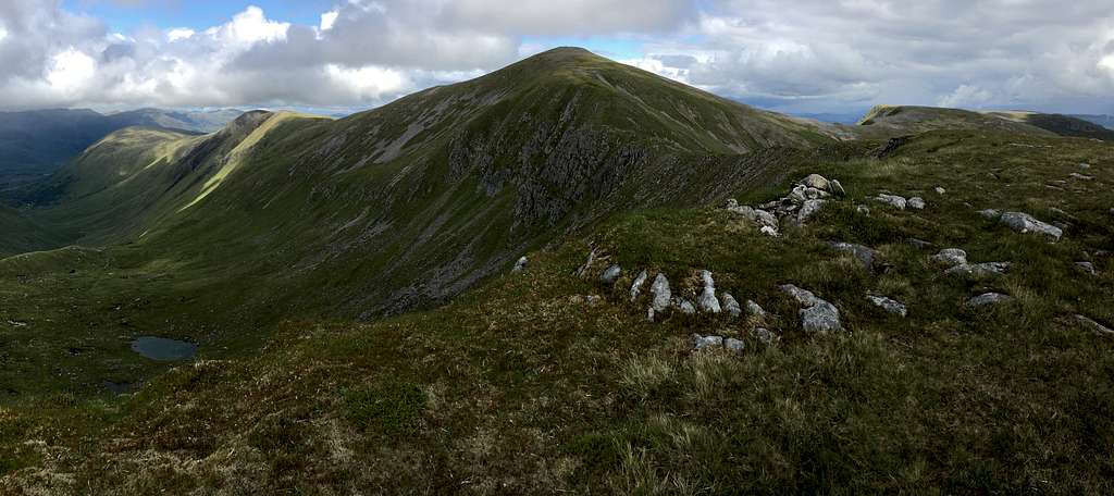
We passed over this quite quickly and headed across the barren ground towards our next destination, the summit pyramid. It was quite a steep ascent up the rough, pathless ground towards the summit of Sgurr nan Conbhairean, at 1109m the highest summit of the day. On the way, we reminisced about our previous visit.
“This part seems harder than I remember.” I said.
“There was snow here last time,” Marie replied. “Perhaps that made it easier?”
“At least, it’s not as windy!”
We reached the large summit cairn at 1.30 pm in cloudy and breezy conditions.
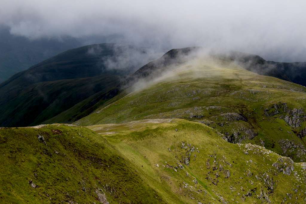
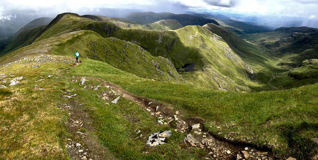
This time, there was no discussion, we continued straight away and descended northwards towards Sail Chaorainn, even though the clouds were blowing in from the west, across the ridge. I hoped the reasonable weather would hold as with each step, we were getting further away from our starting point.
The ridge running north from Sgurr nan Conbhairean seemed an easy angled, broad, grassy ridge. We descended it easily although, I kept checking my map to try to work out exactly where we were.
The clouds were still blowing across the ridge from the west but it was good to be looking into the remote glens to the north. Affric and the Ceannacroc Forest are not easily seen by the occasional visitors such as ourselves. I wondered what routes we might do if we had more time and didn’t have to prioritise particular goals?
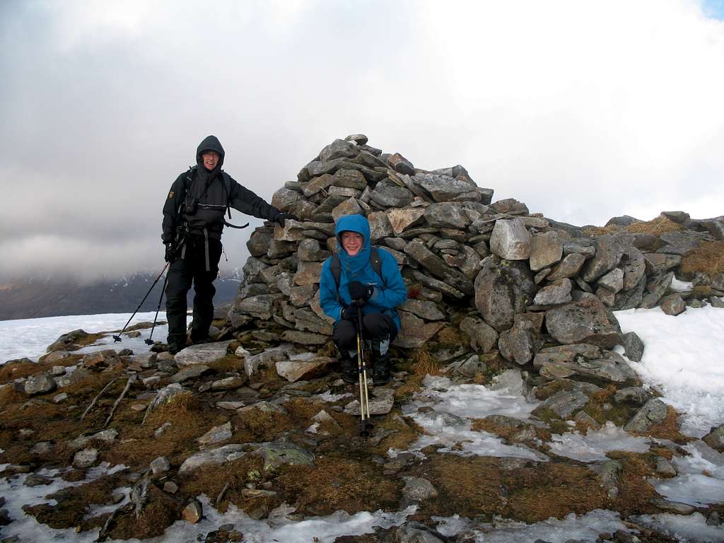
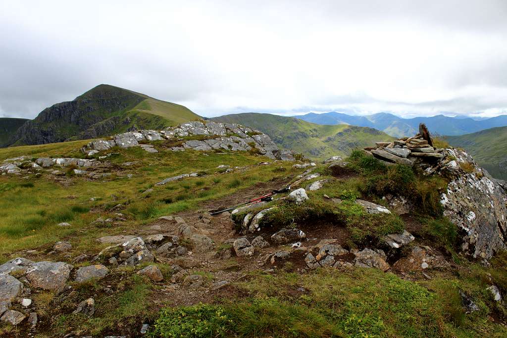
All the guidebooks had said that the summit of Sail Chaorainn was difficult to distinguish, especially as a nearby “top” – a bit further along the ridge – was only 1 metre lower in height!
This relatively easy traverse took us a bit longer than we thought but at 2.20 pm, we reached a small cairn on what appeared to be the high point of the ridge.
“Is this it?” Marie asked, somewhat surprised.
At this point, the views were quite clear, so I checked the map and tried to line up the features shown on it to our surroundings. I identified the ridge of An Reithe – the ascent route from the east - and the corresponding Allt Coire Mheadhoin valley.
“Yes, I think so.” I finally decided.
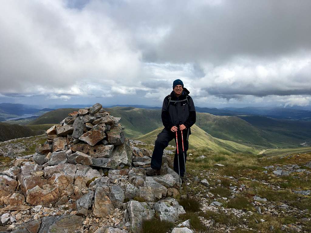
We congratulated ourselves and sat down for some lunch.
While we ate, I kept checking the map. Each time, I convinced myself we were at the correct summit. It seemed like something of an anticlimax after three attempts over more than 30 years.
I took photos and wondered why this summit cairn was so small. Looking ahead towards Carn na Choire Mheadhoin – the next Munro “top” along the ridge – I could see its summit cairn. It was much bigger that this one!
Why would the main summit have a smaller cairn than the subsidiary top? It didn’t make sense.
A seed of doubt had been planted in my mind and the more I thought about it, the more I worried.
“I think maybe we should go on to the next top.” I suddenly announced.
“I thought you said this was the summit?” Marie asked.
“Yes, I think it is. I’m about 90% sure it is but that next cairn is bigger!” I said not very convincingly. “I just want to be sure, you could stay here if you like and I will go and come back.”
“You’re joking!” Marie said. “I don’t want to get back down and find I didn’t climb to the right summit!”
So, we set off for the extended route together.
There was a drop along the narrow, grassy ridge to a col and an easy scramble back up the other side but to help us, the weather had improved and the sun appeared for longer periods.
When we reached the cairn of Carn na Choire Mheadhoin, it was much bigger but looking back along the ridge, I decided that we had been right the first time!
To be honest, as its only 1 metre lower – and has a big cairn – I think I was worried that one day, the SMC will re-classify this as the true summit!
We enjoyed the views around us and after 10 minutes returned the way we had come.
Returning along the same route, the time passed quickly but we had to pass over Sail Chaorainn, descend to a low point at 914m, then re-ascend part way up Sgurr nan Conbhairean. This part seemed steeper than the descent had done earlier but by 4.00 pm, we were heading southwest along another grassy ridge, towards Drochaid an Tuill Easaich, another outlying Munro “top”.
I left the path and headed up to the high point as I had a good view back eastwards towards our traverse and all of the summits we had been over. Now we were descending, I didn’t really want it to finish but hurried on to catch Marie as she had continued down the ridge.
For a while, we had been fearfully watching a grey mass of clouds, covering the mountains to the west, we were convinced they were about to cross the valley and we were going to get soaked.
It didn’t happen, the clouds moved off northwards and missed us completely.
By now, it was sunshine more than it was cloudy and we enjoyed the descent southwards, back towards Loch Cluanie along another grassy ridge.
Westwards, we could see Loch Cluanie and the Cluanie Inn with the mountains on the south side of the Cluanie ridge, peeping out of the clouds.
I think that our route had the best weather for the whole area!
We descended the ridge and hopped across the river by a waterfall to reach the old military road.
Then, we had to follow this back and retrace our steps to get to the car.
Three Munros – Sail Chaorainn at the third attempt – three Munro “tops”, 17 1/2 kilometers over some wild and beautiful countryside in pretty good weather for Scotland! A great day.