I'm curious
Looking back at my photos, I like to know what mountains I've photographed. Often that's easy, sometimes because I've climbed them, otherwise because I usually study the map of the area beforehand, so I already know what to expect. However, for the Cordillera Vilcanota in Southern Peru, I did not have a proper map. Before I went there, I got my information from a book
[1], from various web sites and, last but certainly not least, from my guide Iván, who I had stumbled upon in Arequipa, a few weeks earlier.
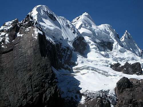
![Ausangate east face]() Ausangate east face
Ausangate east face![The steep mountains north of Campa pass]() The steep, dramatic mountains lining the north side of Campa pass
The steep, dramatic mountains lining the north side of Campa passIt was the last day of our trip. We had climbed Ausangate and were completing the circuit around it. Now, if you're just going to hike the circuit, you can go in either direction. I figured that getting to Ausangate base camp would probably take two days, regardless from which side, so left it up to Iván. Going counterclockwise, as we did, turned out to be an excellent choice, as we ended up crossing the spectacular Campa pass on the last day of our trip, bringing us real close to some dramatic scenery one last time, before heading back to civilization.
We already were reasonably well acclimatized, having explored the volcanoes around Arequipa. If you're not, you might want to start by climbing some lower peaks first, and perhaps refresh your glacier skills along the way. In that case, going clockwise brings you to Campa pass early on, and right beside it awaits Nevado Campa, an easy to climb mountain with a small glacier on top. My guidebook says it's 5500m, and it shouldn't take more than a short day to climb it from a camp below the pass. Or you can drop most of your gear near the pass, climb it from there and continue the circuit afterwards.
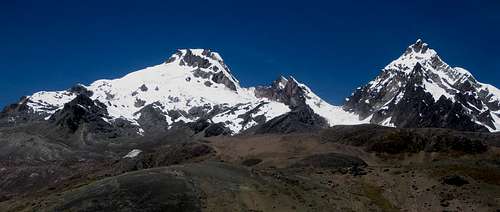
![The Callangate chain in the Cordillera Vilcanota]() The Callangate chain seen from a distance, from near Tinqui
The Callangate chain seen from a distance, from near Tinqui![Collpa Ananta (6110m), the main summit of Callangate]() Collpa Ananta, the main summit of the Callangate chain, from the west.
Collpa Ananta, the main summit of the Callangate chain, from the west.Early on in our trip, Iván
did suggest that if we had some time left at the end, we could have it for desert. Personally, my mind was elsewhere: I was more interested in having a go at Callangate (6110m).
As it turned out, we didn't have time for either. We had planned for two spare days, but needed both of them on Ausangate, and so we ran out of time. However, that didn't make me less curious about Campa. I took plenty of photos near the pass, figuring that I would sort them out later.
Which one is Nevado Campa?
![Pano]()
Panorama of the Cordillera Vilcanota, taken from west of Campa pass.
The pass is the gap on the far right of the photo, but which peak is Nevado Campa?
That 'later' happened a couple of days ago. I was looking at some of my photos from around the pass, trying to put names to the various peaks. I played around with Google Earth, trying to find the viewpoints that gave the same images as I could see on my photos. After a while I had gradually constructed a mental map of the area, but still without most of the labels.
![Cordillera Vilcanota, south of Campa pass (5000m+)]() Nevado Campa, or what's visible of it, from Campa pass. From other photo's and Google maps, I concluded that this isn't quite the summit yet, it must be a little bit further behind.
Nevado Campa, or what's visible of it, from Campa pass. From other photo's and Google maps, I concluded that this isn't quite the summit yet, it must be a little bit further behind.So, which mountain exactly was Nevado Campa? I had three facts to start with:
- It's an easy glacier climb,
- lies just south of the pass
- and has an altitude of 5500m. Of course, such a nice round number is a bit suspicious, so, best to take it with a grain of salt.
The route over Campa pass. Since the pass itself is covered by glaciers, mostly shaded from the strong sun by the big peaks directly to the north, the trail over the pass actually traverses the southern slopes, higher up.
Note: For other mountains in the Cordillera Vilcanota, Google Terrain View consistently gives values that are roughly 30 to 60m lower than those in my guidebook.
Google Terrain View shows one summit just over 5400m, directly south of the pass, but there is another one just over 5520m, 1.5km further SSW. They are connected by a ridge with a saddle over 5300m, which means that the northern one has a prominence of only 100m or so.
Ok, I thought, apparently Campa has two summits, and the true one is the south summit. Then again, perhaps that southern summit has a different name altogether? As for prominence of the south summit, it's a bit over 300m - with respect to Nevado Mariposa (5808m), further to the west.
![Campa I and Campa II]() The two Campa summits from the NW
The two Campa summits from the NWNext, I turned to my own photos again, and compared them with the one of Campa in my guidebook, as well as with plenty of others that I could find on the web. And all these other pictures were of the lower summit!
![Campa (5500m) from the northwest]() A photo I took of Campa that's similar to the one in the guidebook - but with a lot less glacier and more rock
A photo I took of Campa that's similar to the one in the guidebook - but with a lot less glacier and more rock
I was surprised. Not so much that people climb a lower summit of a mountain, but that I could find no reference to the fact that it was basically only a shoulder of a higher mountain! I found plenty of pictures of Campa that were all of the north summit, and plenty of references to it in trip reports and web sites of operators offering trips to the Cordillera Vilcanota. However, I found no pictures of the south summit, and very few references to its very existence at all!
Continuing my research, I finally put the pieces together. From several references, I learned that the two adjacent peaks are named Campa I and Campa II (or Campa Sur). The most interesting reference I found
[2], gives Campa I an altitude of 5485m and Campa II of 5580m. While both are slightly higher than I would expect, the difference between the two is well in agreement with Google maps.
You can find many references to Campa, without the suffix I or II or Sur, in Ausangate circuit descriptions and people's trip reports. Invariably, on closer inspection these references are in fact about Campa I. Climbing it is easy, preferably from the northwest and north (mind you, it's not mere hiking, you'll still need glacier gear - at least for a few more years). I presume that, in casual use, Campa I has been abbreviated to just Campa. Alternatively, dropping the 'I' might result from the fact that, from Campa pass, you can only see Campa I - and not even very well - so there is no need to make a distinction between the two. However, personally, I find it all a bit misleading, suggesting that Campa I is the true summit.
Finding more information about Campa II (or Sur) was a different matter. I couldn't find any reference to its difficulty, and little information about climbing it. Biggar
[1] states it can be climbed from the N side. Looking at my pictures, that looks difficult. Due N is a steep rock face. The NNE ridge looks slightly better, but still not easy. Reference
[2] mentions that it was climbed, but not from which side.
Unfortunately, I haven't seen the other side for myself. The contours show a pretty steep south and southwest face. The contours also show a much gentler summit ridge SE. Now, the resolution of Google Terrain View is a bit course in this area, so the actual ridge might be rather jagged. And besides, it could be a problem to get
on that ridge. Ah well, that's something to explore, next time. There is still plenty to climb there anyway ...
The result
| Annotated panorama taken from west of Campa pass |
This panorama is stitched together from 8 different photos. With a bit of help from Google Earth, I managed to find the location from where I took them: from about 2km west of Campa pass (-13.764,-71.198). After that, and a bit of research, I managed to put names to the various peaks.
The flat topped peak on the far left is Campa I, just south of the pass (which itself is just outside the photo on this side). The sharp peak next to it is Campa II (or Sur). From this viewpoint, the north summit, on the left, may seem higher, but that's only because it's closer.
![The dangerous southwest face of Mariposa]() Closer view of Mariposa from the other side
Closer view of Mariposa from the other sideStill on the left is the long ridge of Mariposa (5808m), to the SW. It looks a lot more dramatic from the other side!
To the right of Mariposa there are two rocky summits. It's not very clear to see, but sticking out above the rightmost one, and not connected by any ridge but actually two kilometers further away and much higher, is Ausangate (6372m), the highest mountain of the Cordillera Vilcanota.
I don't know the name of the hill in the center, WNW of the pass. To get back to civilization, you can go either left or right of it. There are plenty of lakes and streams and good campsites along the way. Both ways lead to the small village of Pacchanta, from where a dirt road brings you back to Tinqui and the new main road to Cuzco. If you're lucky, as we were, you can find transport to Tinqui in Pacchanta. If not, estimate it's no more than two to three more hours - and all downhill.
On the right are the southern peaks of the Callangate chain, which line the north side of the pass. The main summit of the chain isn't visible yet - you'll have to go further west from the pass for that.
The two in a nutshell
| ![Nevado Campa I, seen from the NW]() Campa I from the WNW
Campa I from the WNW | ![Nevado Campa II, seen from the NW]() Campa II from the NW
Campa II from the NW |
| Location | -13.776,-71.179 | -13.788,-71.184 |
| Elevation | 5485m | 5580m |
| Normal Route | Approach from the NW, climb the last bit from the N. | I don't know, but without additional info, I would first go to the saddle with Campa I, just NNE of the summit, and from there try to climb the ridge. In the photo above, that's on the left. |
References
[1] The Andes - A guide for climbers, by John Biggar. 3rd edition, 2005. ISBN 0953608727
[2] Herbert Konnerth
in the American Alpine Journal 1975, 38.70, page 171. ISBN 0930410726


Comments
Post a Comment