Intro
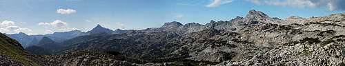
Those who seek to read about great adventures will find nothing interesting in this 3-days trek report. What I'd like to tell here is, how great area Steinernes Meer is for long hikes and for those who are looking for ideas, how to plan the visit of the area, to present one of the most beautiful itineraries.
Our goal was first to ascend the two cardinal (also among the highest) summits of Steinernes Meer area and to do a round tour which would show us most of the characteristics of the great plateau. We did the trek our way, of course. That means carrying everything with us (tent, sleeping bags, food and drinks), stopping at mountain huts only in emergency - additional beer, for example. That makes you feel free, dependent only on weather and your own fitness.
Day 1
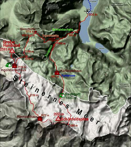
In a nice afternoon the long wish to see again the heavenly beautiful place of St. Bartholomea became true. With the sounds of traditional trumpet the boat landed by the meadow, we made a short sightseeing and soon went on along the lake of Koenigsee. With these heavy backpacks we still need to reach good 1000 meters higher till the night. Nice path along the lake, waterfall, higher crossing its creek bed and soon afterwards we are already below Saugasse - a steep passage between Simetsberg and Gjaidkopf. Despite a rugged terrain the path is still smooth and broad, it bounces from wall to wall in endless turns and gains thus some 400 meters. Really, done with German precision and care, perhaps also because this was in the past the king's hunting area. Above, slightly ascending over the plateau, we reach Kaerlinger haus, 1630 m, near the green Funtensee. We don't need to enter; on the terrace we just smile seeing a brush on chain and the instruction to clean shoes before entering the house. We'll not consider this as the next item to carry with our tent!
![Saugasse]() In Saugasse In Saugasse |
![At Kaerlingerhaus]() By Kaerlingerhaus By Kaerlingerhaus |
It starts raining. We could hide a tent on the other side of the lake, but we still have some two hours of the day, so why not ascending higher on the plateau? Schoenfeldspitze shows piercing clouds and the path directs us straight towards it. Higher, we fear not to find an appropriate meadow. Steinernes Meer is more and more becoming a true sea of stones. In Baumgartl two places could host our tent, I choose the slanted one in a shallow valley. As the tent is up, it starts raining stronger. As I'm sliding in that bloody tent, I put rucksack to my feet, forgetting that when it's sticking to tent walls it will make rain to pour in the tent. As Jasmina is in the lower part, I don't feel much water, but none of us slept much that night. I couldn't lie on the damn rock and was sliding down, Jasmina was more and more fighting with floods.
Day 2
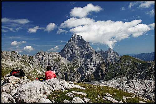
The dawn found us all wet and tired. We decided to continue the hike immediately, to reach the sun as soon as possible. Half an hour higher it started to rain again. There's a small hut, but we saw a man observing the area with a binocular, so we kept away, looking for a possible shelter. Then Jasmina fell, you can imagine, on a flat terrain, stepping on a stone which overturned. She hurt her knee, hand and finger, luckilly not seriously. With a dirty patch I stopped the finger to bleed, but the morale in the team was very low. Luckilly the sun emerged and we decided for a longer breakfast.
![On Baumgartl]() We are all wet We are all wet |
![Schoenfeldspitze]() Schoenfeldspitze Schoenfeldspitze |
![The Sea of Stones]() The Sea of Stones The Sea of Stones |
![On Steinernes Meer]() Breakfast Breakfast |
In a slightly better mood we continued through Schoenfeldgrube and on Buchauerscharte. Now the mountaineering part starts. On Jasmina's questions about climbing difficulties - Schoenfeldspitze looked really very steep from all sides - I could answer only that it was said it is marked and that difficulties don't exceed UIAA I degree. The first part was just walk up, then Schoenecknieder presented itself as a sharp ridge which required an exposed downclimb traverse. All would be fine if we didn't have these heavy backpacks and if morale was higher. When the sharp summit of Schoenfeldspitze showed out of clouds, we saw a few people climbing it, like they were trying to reach a church tower roof top. Are there any protection devices? We moved forward slowly and carefully. When the route turned up again, we realized how it's going to be till the top - just directly up in easy and exposed climbing. No protection devices though. In the upper part of the SE ridge we met first people, going down already. Soon afterwards we reached the top.
![On Schoenfeldspitze east ridge]() Above Buchauerscharte Above Buchauerscharte |
![On Schoenfeldspitze east ridge]() Schoenfeldspitze E ridge Schoenfeldspitze E ridge |
![Above the Sea of Stones]() On Schoenfeldspitze On Schoenfeldspitze |
![Koenigsee from Schoenfeldspitze]() Koenigsee from Schoenfeldspitze
Koenigsee from Schoenfeldspitze![On the W ridge of Schoenfeldspitze]() On the west ridge
On the west ridgeYes, as Michael says, the big cross doesn't look aesthetic. But it's a kind of landmark and if not liking it, one can focus attention on panorama. Due to clouds moving around the summit the view was not fully open, but nice enough to enjoy it. But curiosity and wish to overcome all harder details of today's trek, soon pushed us down from the summit. Downclimbing usually requires more care, so we were slow again. Some 50 meters below the top, the route to Riemannhaus (normal ascent on Schoenfeldspitze) deters westwards. Jasmina expected it to be easier, but the only difference is that on one or two places there are a few steel hooks helping you. Without them the first traverse would be much harder and it is really exposed. Later the route continues by a comfortable band, but gaining the west ridge, difficulties are not over yet. You stil climb down over a steep terrain. Then a young local guy comes up with his foreign friend, warning me to put my poles on backpack, because another almost "vertical" climbing detail is below us. No, as long as it's not harder than degree one, I still prefer to climb with poles. That step is may be a bit harder, but soon we are down and with some more care further on screes below. In good half an hour the winding path gets us to Riemannhaus, the most frequented base on Steinernes Meer. Lunch time and, as said, additional beer.
![Riemannhaus]() Riemannhaus Riemannhaus |
![Through the Sea of Stones]() Through the Sea of Stones
Through the Sea of Stones![Drying wet equipment]() Drying equipment
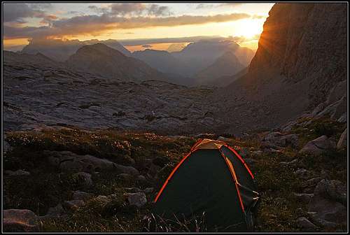
Drying equipmentOnehour later we are on the way into the stone desert of Steinernes Meer. That's a real sea of stones! The scene is not new for us. In Julian Alps a very similar and almost as broad plateau is on Kanin mountain. But the ladscape is still fascinating. The Eichstaetter Weg crosses the whole plateau from Riemannhaus to Ingolstaedterhaus - some 3 hours of walk. But we soon make a break to dry all our equipment. The sun is hot and stomachs full, in one hour also sleeping bags are almost dry. Now go on! The path is winding through the rocky landscape, up and down, left and right. Never hurry here, it can kill your motivation to get somewhere quickly! Just observe rare nice flowers, interesting karst features, carved by water and wind, on many places you can also find petrified fossiles in rocks. After good three hours we reach Ingolstaedterhaus. The sun is low already, but still enough time to search for a place to sleep. Jasmina is lucky and skillful also. Behind a high rock barrier she finds an ideal place to set up a tent. Five minutes from the hut, but nobody disturbs us. From our tent we observe a great sunset, then it soon gets cold and we afford ourselves a long, healthy sleep.
![Evening below Hundstod]() Sunset near Ingolstaedterhaus
Sunset near IngolstaedterhausDay 3
![On Grosser Hundstod]() On the summit of Grosser Hundstod
On the summit of Grosser Hundstod![The ascent on Grosser Hundstod]() The ascent on Grosser Hundstod
The ascent on Grosser Hundstod"It's all cloudy", I announce disappointed, peeking out of our tent. But Jasmina only laughs. "Low morale again, ha. It's only too early". And indeed. Soon a wonderful day begins and even without breakfast we head up towards the summit of Grosser Hundstod. But first we hide more than half of our equipment. Soon we reach the base of the mountain. A steep, exposed but comfortable path is crossing the lower, grassy slopes. Then it overcomes a few rocks, one detail requires again some easy climbing and above it you already see the summit slope. But the cross is still high above. After one good hour from the hut we reach it and a broad panorama on all sides opens. Today the sky is much more clear, only far in the distance it's hazy.
Now the big descent will start. We calculate that down to St. Bartholomea we have 2000 meters of altitude difference. But in between there are two passes to cross, the first one requiring 200 and the other one another 100 meters of ascent. So we'll do today some 900 meters of ascent, 2300 meters of descent and quite some distance. We carefully descend to the hut, take all equipment and continue towards the saddle of Hundstodgatterl. There only we'll have breakfast. In one hour the path descends to the crossroads below the saddle, then over very unpleasant karst terrain marks ascend on the saddle. In the middle of that slope there are three men resting. One of them hurt his ankle, but also we have nothing to help him. As we leave them, we still hear the poor "hundschmerz", as we name him, screaming back there. Half an hour later we hear a helicopter overflying the area...
On Hundstodgatterl suddenly a view opens, which surpasses everything we saw so far in Berchtesgaden Alps. Watzmann south peak is rising above Wimbachtal in its full glory. If this isn't one of the greatest views in Berchtesgaden Alps, then I haven't seen half of Alps! It reminds me on Montaž, seen from Dunja valley. The latter is wilder, Watzmann is having somewhat a more regular shape. Yes, there, on a grassy bump below Hundstodgatterl there's the right place for today's breakfast!
![The beauty of Watzmann]() The great Watzmann from below Hundstodgatterl
The great Watzmann from below HundstodgatterlContinuing the descent we meet quite a lot of peole, coming up from Wimbachgrieshuette. God thanks that we are not doing the trek in the opposite way. On the whole long descent to Trischuebl we have the great view on Watzmann in front of our eyes. A small pond below Trischuebl offers the first water after two days, then we ascend to the saddle and continue again down towards Koenigsee. Still more than 1150 m to descend. The path is now winding down through nice mountain gardens, among rocks, approaching the huge wall of Gjaidkopf. It's a completely unimportant mountain this Gjaidkopf, but out of this rugged world its north wall is rising almost vertically some 700 meters! Just like that! The path descends through the valley below the wall, then we branch left towards a passage, called Sigeretplatte. The path descends to the abyss, then crosses by a nice ledge, this time well protected by a cable. From the slopes on the other side of the passage, we already observe Saugasse passage, across the valley. The big "sausage" of our hike is closing, after coming down in the valley we just need to go down by the already known path to the lake. The first signs of fatigue are showing up, but Jasmina is continuing with a strong pace. The St. Bartholomea Biergarten is calling loudly!
![Approaching Trischuebl]() Approaching Trischuebl Approaching Trischuebl |
![Sallet at Koenigsee]() Descending towards Koenigsee Descending towards Koenigsee |
And then? After the boat brings us to Koenigsee, we walk another kilometer to our car and drive directly home - as our vignette for Austrian highways is no more valid, it takes us 5 hours. Good to practice my concentration!


Comments
Post a Comment