
-
 20317 Hits
-
 83.1% Score
-
 16 Votes
|
|
Canyon |
|---|---|
|
|
35.82400°N / 106.568°W |
|
|
Hiking, Canyoneering |
|
|
Spring, Summer, Fall |
|
|
Overview
East Fork of the Jemez River
With its source deep in the high country of the Jemez Mountains, the East Fork of the Jemez River winds its way through the Valles Caldera National Preserve, pine forests, and gentle volcanic hills. Ultimately the East Fork joins with the San Antonio River at Battleship Rock to form the Jemez River, which anchors the southern end of the Jemez Mountains. Along its length, the Jemez River and the East Fork have created some spectacular sights including the famous Soda Dam and Jemez Falls, and long been a destination for small-stream trout fishermen. Designated as a wild and scenic river, the East Fork of the Jemez is a high-country gem.
Hidden along the length of the East Fork are various small canyons carved out of ancient volcanic tuff. The best, and most well-known, is the East Fork Box. This popular destination is a short 3-mile roundtrip hike to a ¼-mile long slot canyon filled with pools, a waterfall, and steep walls of eroded volcanic tuff. On warm summer days, there are always people here wading and swimming in the various pools.
The American Canyoneering Academy rating for this canyon would be a 1B I meaning that the canyon is non-technical, has a small current with possible pools to wade or swim, and only takes a few hours to complete. As with all canyons, please remain aware of the dangers of flash floods. Do not attempt to hike this canyon when there is any rain in the watershed.
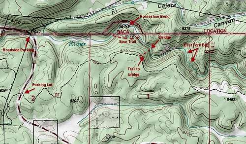 East Fork Box Map
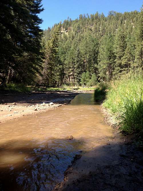
At first the river winds its way through a gentle valley with grassy meadows. Soon though, cliffs start to intrude. At some of these points, you will be forced to navigate the streambed.
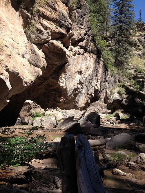
Entrance to the Box
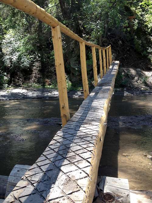
Wooden Bridge
At one point, the river makes a big horseshoe bend to the north. There used to be a bridge across the river here, but it is now gone. On the southside of the stream is a signpost and trail sign marking a trail over the spur of the hill. The horseshoe bend is technically on private property. There used to be a fence and signs asking people not to trespass. The appropriate solution was to take the trail over the hill as a bypass. But on current maps, it appears that the forest service has worked out a solution with the owner, and it is now possible to continue in the river and follow the horseshoe bend.
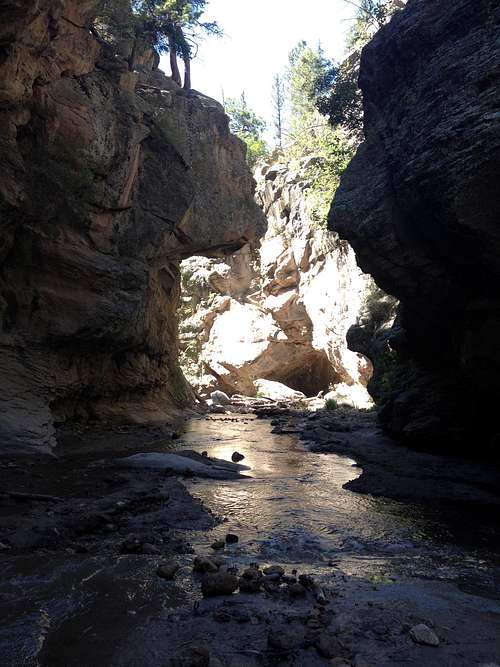
Once past the horseshoe, the river continues on for another hundred yards until you hit a wooden footbridge. This bridge used to mark the junction of the official East Fork trail with the river. In current years, the bridge has been pulled loose from its mooring by flash floods and carried downstream a couple hundred yards where it is now stuck against some rocks. Upstream one can see the old metal rods where the official east Fork Trail meets the river. Continuing up-canyon, the East Fork Box will appear in about two hundred yards past the original site of the bridge. At that point, the canyon immediately narrows, opens up, then narrows again. Keep your eyes peeled for floating rocks. These pieces of volcanic tuff have trapped air. These rocks are super-interesting to watch as they bob in the river.
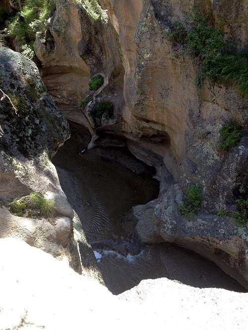
East Fork Box from Above
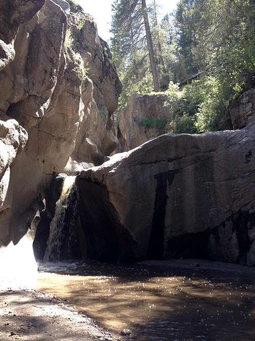
Waterfall in the Narrows
Here is where most people stop. There are pools to play in, and small waterfalls to watch. If you continue upstream, you will quickly be stopped by a 6-foot wall and waterfall. Another option is to surmount the cliffs to the northeast and drop down into the slot from above. Some of the pools in the canyon are deep enough to swim without touching the bottom. Occasionally, flash floods fill the pools with gravel and other things hidden beneath the dark water. At one point the pools were shallow enough to hike through. No matter what state the canyon is in, have fun exploring the slot carved through volcanic tuff!
If you are hiking to the canyon from the parking area, follow the marked trail until it drops into the river. Once you hit the river, head right (east) to the box.
![Volcanic Cliffs]()
Volcanic Cliffs
From Albuquerque
Getting There
Volcanic Cliffs
Take I-25 north to Bernalillo exit 242. Take 550 west through Bernalillo 23.3 miles to the small town of San Ysidro. Turn north onto NM 4 and travel 31.8 miles through the Jemez Pueblo, Jemez Springs, past Battleship Rock, past the turnoff for Fenton Lake State Park, and past the Jemez Falls camping ground. At 31.8 miles, there will be a curve in the road, and probably other cars parked along the road. This is your destination (N 35 49.6493 W 106 35.4007). If you miss it, you will find the official signed parking area for the East Fork Box approximately ½ mile down the road on the eastside (N 35 49.2496 W 106 35.4602). Turn around and backtrack or you can park there and follow the official trail. Total travel time from Albuquerque is approximately 1 ½ hours.
From Los Alamos
From the junction of NM 4 and W Jemez Rd (501), travel 17.6 miles west to the roadside parking (N 35 49.6493 W 106 35.4007). The roadside parking will be ½ mile past the official signed parking lot and trailhead (N 35 49.2496 W 106 35.4602) for the East Fork Box. Total travel time from Los Alamos is approximately 25 minutes.
Red Tape
The East Fork Box is in the Santa Fe National Forest. There is no red tape. The 7.5 minute USGS quad is Redondo Peak (NM).
Camping
Primitive camping is allowed anywhere in the forest with the only restriction being that you must camp 100 feet from any water source to keep riparian areas healthy.
Nearby Jemez Falls Campground boasts 52 developed sites with picnic tables and fire rings. Paved access allows RVs and trailers up to 40 feet long. There are vault toilets, but no dumping station. Check in time is 3pm, check out is 2pm with a maximum 14 day stay. No reservations are accepted, it is first-come, first-serve, and is $10 per site per night.
External Links
Jemez Falls Campground