
-
 18113 Hits
-
 92.59% Score
-
 39 Votes
|
|
Canyon |
|---|---|
|
|
35.66320°N / 106.4108°W |
|
|
Hiking, Canyoneering |
|
|
Spring, Summer, Fall, Winter |
|
|
Overview
Tent Rocks Canyon is located in the Kasha-Katuwe Tent Rocks National Monument on the Pajarito Plateau of the eastern slopes of the Jemez Mountains. The National Monument is 40 miles southwest of Santa Fe and 55 miles north of Albuquerque. Cochiti Reservoir and Bandelier National Monument lie to the north. To the east is the Pueblo de Cochiti Indian Reservation, and on the western side, the Jemez Mountains. Kasha-Katuwe means 'white cliffs' in the Keresan language of the Cochiti tribe.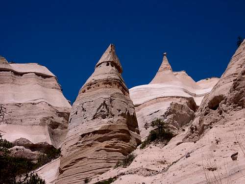
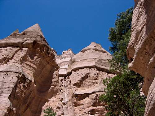
Tent Rock Hoodoos
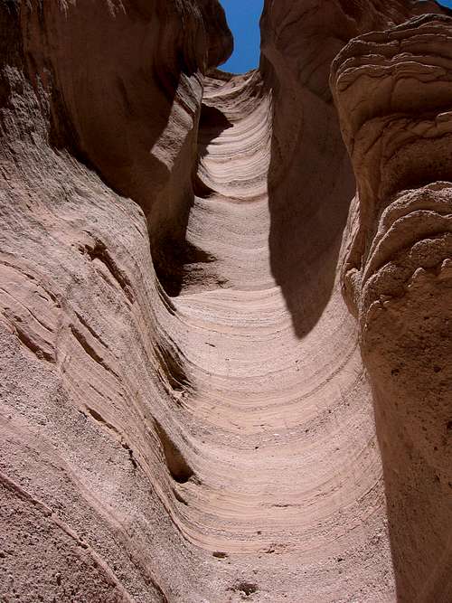
Tent Rocks Canyon is a rare New Mexico slot carved in 1,000 feet of ash, tuff and pumice of volcanic activity. Found in the canyon are small rounded balls of obsidian (volcanic glass...also known as 'Apache Tears') which are further evidence of the mighty geologic forces that have shaped this area. The Tent Rock Hoodoos themselves are made of the soft tuff but capped with slightly harder rock which allows erosion to happen on the perimeter, but prevents erosion in the center. Some of the cones have lost their caprock and are now starting to erode away. The combination of soft tuff and flash floods have carved this spectacular slot.
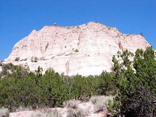
The White Cliffs
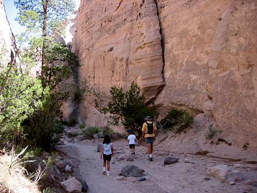
Entering the Canyon
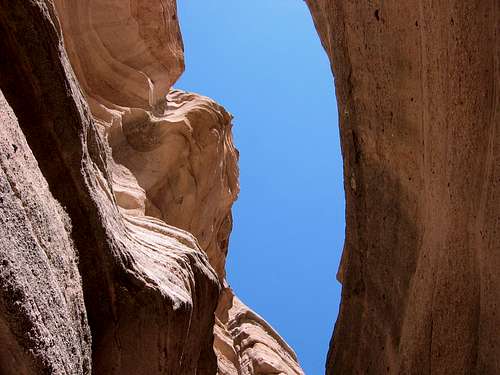
Slit of Sky
The Dance of Shadows
Tent Rocks and Tent Rocks Canyon were featured in the 1985 revisionist western Silverado written and directed by Lawrence Kasdan. Tent Rocks was the hideout for Danny Glover's character. The cone-shaped formations are obvious in the background of several scenes, and I believe the 'cave' Danny Glover hid out in was filmed in a section of the slot at night.
The American Canyoneering Academy rating system would consider this canyon very easy at 1A I meaning that it is a non-technical dry canyon that can be accomplished in just a few hours. The canyon may be hiked at all times of the year, but summer may be extremely hot and the July-August monsoon season can bring deadly flash floods through the canyon. Do not attempt to hike this canyon during wet weather!!
Canyon Description
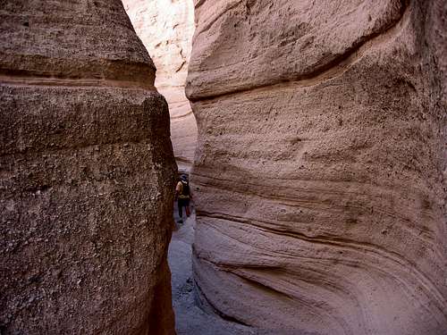
The Slot
At first the canyon boasts towering walls, but no real slot. However, soon the walls narrow and the real slot takes over. Just follow the winding bed as it climbs higher. Several parts are extremely narrow and you may even have to turn sideways to get through the slot. You may also notice that people have carved into the walls of tuff. Please refrain from doing so and leave the area natural for others to enjoy.
Eventually, the walls narrow and there are several boulders that have collapsed into the canyon forming a natural boulder cave that you have to navigate. From there the canyon starts to open up and it is a steeper climb among hoodoos until you reach the top of the mesa. Return the way you came.
Getting There
From Albuquerque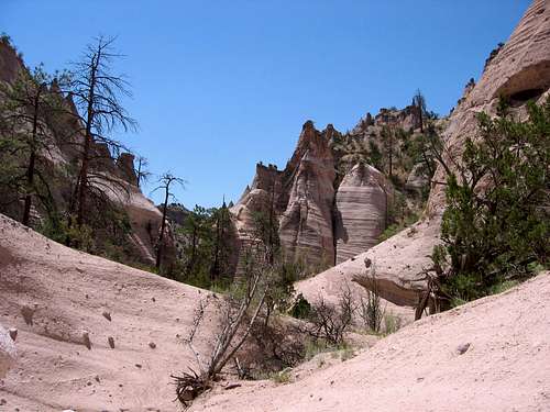
Looking back down the canyon from near the top of the mesa
Take I-25 north and exit at Santo Domingo/Cochiti Lake Recreation Area (Exit 259) onto NM 22 heading west. Turn right at the Pueblo water tower painted like a drum onto Tribal Route 92. This connects to Forest Road 266, becomes well-maintained gravel, and you will follow this about 5 miles to the parking area.
From Santa Fe
Take I-25 south and take the Cochiti Pueblo Exit 264 off I-25 onto NM 16. Turn right onto NM 22. Be sure to follow the jog in the road and the signs towards the Cochiti Pueblo underneath the dam at Cochiti Reservoir. If you get to Cochiti Reservoir Overlook, you have gone too far. Go back and look for the signs. From NM 22, hang a right onto Tribal Route 92 which becomes the well-maintained gravel Forest Road 266. Follow this about 5 miles to the parking area.
Red Tape
Kasha-Katuwe Tent Rocks National Monument is maintained and administered by the Bureau of Land Management New Mexico. The entrance fee is $5 per vehicle. Hours are 8-5 during the winter and 7-7 during the summer. The area is for foot traffic only, no motorized vehicles are allowed on the trails. Collecting 'Apache Tears' (obsidian balls) and Geocaching are strictly prohibited.Because access is through Cochiti Tribal land, there may be times when the road may be closed, but a notice about the closure will be posted at the gate by the Tribal Governor.
Dogs are currently not allowed at Tent Rocks for safety concerns. The BLM is working to decide if it will be temporary or permanent.
Camping
Towering Tuff
Tent sites are $5 per night. RV with hookups are $12 per night.
Reservations for campsites are available through the Recreation.gov website.
External Links
Pueblo de CochitiKasha-Katuwe Tent Rocks National Monument BLM Site
Cochiti Reservoir
Recreation.gov
American Canyoneering Academy
davebobk47 - Jun 6, 2009 3:26 pm - Voted 10/10
DogsJust an FYI dogs are no longer allowed in to Tent Rocks. In the past rangers even encouranged me to bring my dog but today after driving all the way up there I was turned away because I had my dog with me. Here is the website addressing this issue: http://www.blm.gov/nm/st/en/info/newsroom/2009/may/kasha-katuwe_tent.html
hans.schenk - Jul 27, 2009 7:45 pm - Hasn't voted
Re: DogsThanks for the heads-up. I will change the page to reflect the info when I have a bit of time. Sorry about not responding sooner, but I've been in Africa for 2 months.
davebobk47 - Jul 31, 2009 11:25 am - Voted 10/10
Re: DogsNo worries. From the sounds of it, it may be a temporary thing. I haven't been up there since my previous post so I don't know if this is continuing, or for how long.
BLMsabaker - Mar 30, 2010 2:39 pm - Hasn't voted
Road and Monumnet ClosureI'm with the BLM in Santa Fe, New Mexico. Kasha-Katuwe Tent Rocks National Monument will close for about six weeks between June 1 - July 31, 2010, in order to pave the road to the Monument. Once the contract is awarded we will announce the specific dates. For more information, please check out www.blm.gov/nm/TentRocksClosure. We're sorry for any inconvenience this may cause and hope visitors can schedule their trips to the Monument before or after the closure.
hans.schenk - Apr 1, 2010 4:23 pm - Hasn't voted
Re: Road and Monumnet ClosureThanks for the info!