

Comments
No comments posted yet.
|
|
Trip Report |
|---|---|
|
|
28.08795°N / 17.34073°W |
|
|
Jan 24, 2020 |
|
|
Hiking |
|
|
Winter |
“That was hell!” I slumped down onto our hotel bed after we had arrived in the resort of Valle Gran Rey, La Gomera. Marie held her hand over her stomach, a grimace on her face.
“I thought I was going to be sick,” she said.
We had just had a very arduous journey!
Now, I am well aware of the book “The worst journey in the world” by Apsley Cherry-Garrard. I have never read it but one of my friends has read it several times and he loves it! It is an account written by one of 3 men who were part of Scott’s Terra Nova expedition with an ambition to recover Emperor Penguin eggs from the Ross ice shelf in Antartica. They succeeded but barely survived the freezing ordeal.
I am not trying to compare our journey to theirs…. but I couldn’t get the title of the book out of my mind!
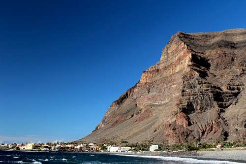
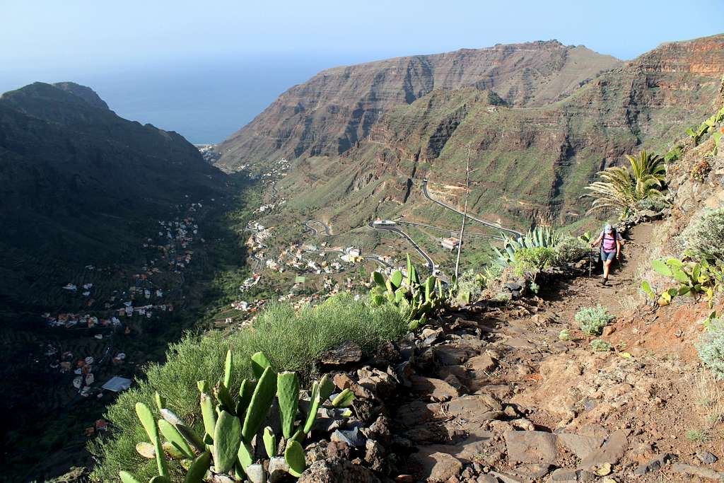
The journey to Valle Gran Rey (or VGR as it became known to us) was always going to be a long one for a trip within Europe. Leaving home at 5.30 am, in a taxi to the airport – a 4-hour flight to Tenerife – bus to the docks at Los Cristianos – ferry to San Sebastian on La Gomera – bus to VGR to arrive at 6.30 pm, thirteen hours later!
However, although the journey was uncomfortably long, it was the last 2-hour bus ride that really became the abiding memory. The main road across the island from the east to the south-west rises from sea level to traverse a forested mountain ridge at over 1000 meters in a series of loops, switch backs and hairpin bends – there really isn’t a straight bit in it – only to then plunge down the Valle Gran Rey and back to sea level in a spectacular valley. It was this part of the journey that really earned the title!
“This place will have to be really stunning to make me want to do that journey again.” I exclaimed, sitting on the bed.
And of course, at the end of the holiday, we would have to do it all again in reverse!
A long time before that happened, I realised I would have to retract my original statement and accept that La Gomera really is a stunning place.
Situated on the south west part of La Gomera, VGR is the resort that has the largest amount of accommodation, the most shops and the best bus service on the island. As a lot of the best walks are in this region too, it makes sense to stay there. Like many of the Canary Islands, the bus service is not great but we had decided to try to get around just using this and our legs! Over the two weeks we were there, we had 4 easy/rest days, we completed 11 of the walks in our guidebooks plus a few others that we made up ourselves and had a thoroughly good time.
For those of you who may have visited some of the other Canary Islands, VGR is not your usual sort of resort. There are no night clubs, no bars with loud rap music and very few children. There are bars and restaurants with musicians playing (often outside), impromptu jam sessions and performance art on the beach and lots of old Germans (older than me even!) with long grey hair, wispy beards and tie-dyed t-shirts living in motor homes!
A time machine to take you back to the early 1970s!
Here are some of the best things we did.
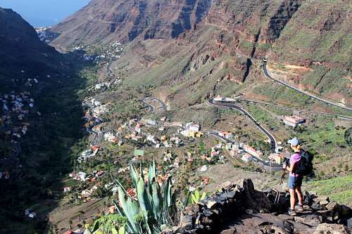
This was a route we did on our third day, it wasn’t the most striking route of the trip but was an excellent introduction to many of the places and views we would become familiar with.
We rushed through breakfast to get to the bus station at La Calera for the 8.00 am bus. It was dark up until the time we left the hotel and walked up the road under a lightening sky. The temperature was quite pleasant at that time in the morning, so we had only a t-shirt and waistcoat along with our trousers. We had been told to get the bus from the bus station as it apparently filled up quickly but there was no problems as it journeyed around the town except for the driver who had to constantly explain where he was going to prospective passengers! We were on the Linea 8 bus to Vallerhermoso and wanted to get off at Arure to start our walk, a small village at the head of the Valle Gran Rey.
We got off the bus and immediately got a shock – it was freezing cold! The journey had taken us from sea level up to about 825m and in the shade of the mountain ridges, it was really cold. A stiff breeze blew across the rounded hills although, there was lots of blue sky.
We quickly put on our spare clothing.
“Glad I bought my hat and gloves.” Marie said as she put them on.
“I left mine in the hotel.” I replied rather disgruntledly.
The first part of the route took us around Arure and up to Acardece, passing a few farms and crossing open heathland. It reminded me a little of Cornwall in the west of England, except it was a lot higher. As well as seeing Goats, Chickens and Pigs on the farms, we had our first sightings of Kestrels, a bird we often see in England. Except this was the Canary Island sub species, not something we could tell at the time.
We crossed the dam wall of a small reservoir and continued along a quiet road. The sun was up now and it was getting warmer. Soon we emerged from some woods onto another quiet road and arrived in the next village, Las Hayas. Here we joined the GR 131, one of two long distance footpaths on the island. We were to become familiar with long stretches of both of them.
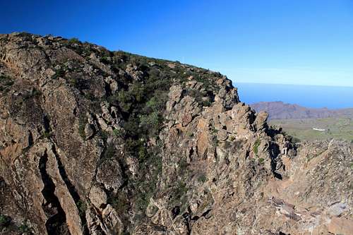
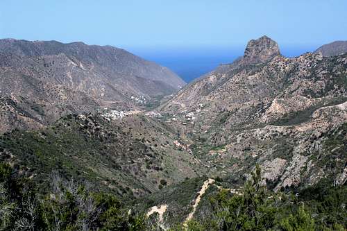
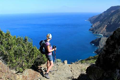
Up until this point, our views had been pretty ordinary but that changed as we left the road and ascended through Palm trees and shrubs to a mountain ridge. Suddenly, we came to a viewpoint overlooking the Barranco del Agua, a deep canyon cut into the side of the plateau.
La Gomera has been shaped by two natural forces. Originally, the whole island was created by volcanic activity – something that is evident everywhere. Then, water has eroded Barranco’s (ravines) into the soft ash and dusty soil. People and vegetation have taken up residence where they could along the sides of hills and valleys.
We admired the views down towards the sea and spotted two more Kestrels hunting along the top of the valley cliffs. Our path continued down slightly and around the steep cliffs at the top to cross some man-made terraces to reach the other side of the Barranco. The path turns upwards here to ascend to the next town, El Cercado.
We wandered down the street – still on GR 131 - and decided to stop at the Bar Victoria for some light refreshment – one of the advantages of these routes is the bar and restaurant facilities along the way. El Cercado, like the other towns here, is pretty quiet except for the chatter of the odd hikers like us and the blaring loud hailer of the man with a van selling his wares to the locals!
The GR 131 continued from the next ridge and once we got there, we could see the town of Chipude with the Fortaleza – one of the few summits on the island – in the background. Soon, we reached the main square of Chipude. It had taken us about 4 hours from Arure.
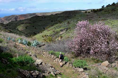
From the main square, we descended down a cobblestone path, through quaint, colourful houses to the main road. A short way along this we took a footpath down across open countryside, heading back to VGR. The angle of descent here was very gentle and the path was flanked by dry-stoned walls, Palm trees, Euphorbia and the lovely pink blossomed trees we often saw.
“What kind of trees are they?” Marie asked as we passed close by some.
“I’m not sure,” I replied.
There were some dried fruits on the trees, I picked one and opened it up.
“It’s an Almond.” I exclaimed.
The route continued downwards before it opened up into a new valley, this was the upper reaches of the Barranco de Argaga, a beautiful and wild valley. The route followed an old water channel, something we found reminiscent of the Levadas of Madeira, before it descended to cross the Barranco to the far side.
By now, the afternoon had become cloudy and the colours had become muted in the flat light. Nevertheless, we could appreciate the Aloe Vera, palm trees and Euphorbia which covered the hillsides.
“I wish we could see this in the sunshine…” I voiced my thoughts. “Maybe we will come back later in the trip?”
|
|
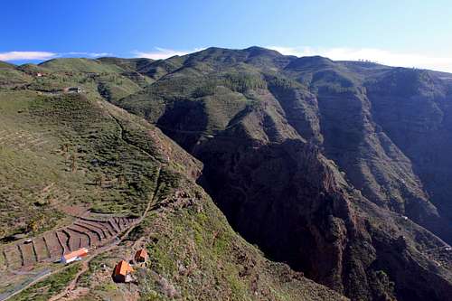
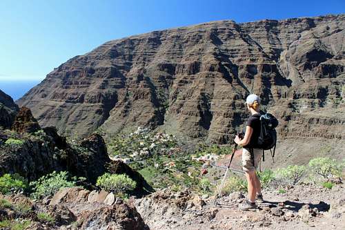
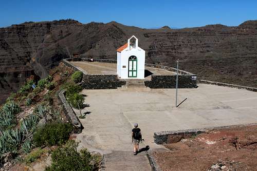
We crossed the crest of the ridge above VGR at the Degollada del Cerrillal and descended the GR 132 (the other long-distance path) into the valley. We had already had some experience on this steep path but found it a bit easier this time. We descended quite quickly and enjoyed the views of the valley. By the time we reached the Ermita de los Reyes, the sun was out again.
We rested on a bench outside the Ermita, a chapel in a peaceful setting.
“I really enjoyed that.” Marie said.
“Yes, and we did it quite quickly.” I agreed.
We strolled back into town and our hotel, with plenty of time for a beer on the rooftop terrace and a chance to watch the sun go down.
This was Marie’s favourite hike of the trip. A few days had passed and our bus journey, this time to the town of Chipude, had become more crowded. We left the bus stop in the town square and as always, all the passengers went separate ways and we were alone in the sunshine.
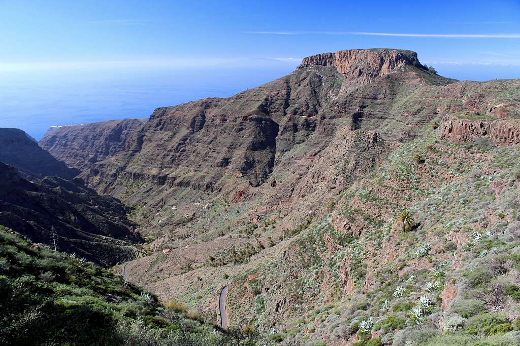
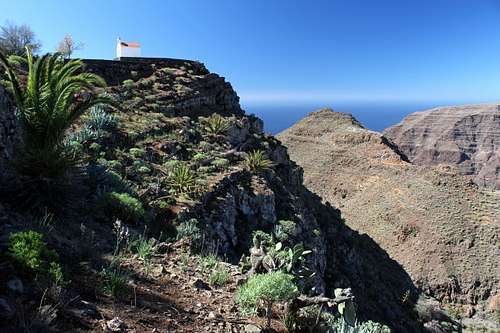
Once again, on the GR 131, we could see our first objective up ahead, the Fortaleza. This is an extrusion of rock, sticking up above the surrounding terrain, a fortress like plateau. Passing through the hamlet of Pavon, we ascended to the Fortaleza saddle and turned off the GR131 to ascend steeply towards the top. The route has been made easier by the construction of steps, which end at the rim of the plateau. Then there is a short, easy scramble up a jumble of rocks to regain the path.
I had fallen behind, taking photos and by the time I reached Marie, she was chatting to an English couple.
“Yes, we’re here for a month.” The woman was saying.
“A month? Lucky you!” Marie replied.
“We come every two or three years,” the man continued. “This is our twelfth visit!”
La Gomera inspires great devotion in its followers.
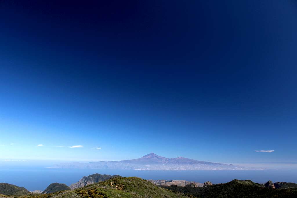
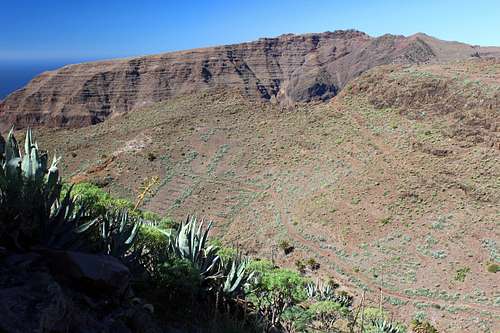
The top of the Fortaleza plateau is very rough and rocky but a path has been cleared around the edges so we could enjoy the extensive views. Southwards, across the sea we could see the island of El Hierro and north – westwards, La Palma, both apparently floating on a hazy cloud above the water. According to our guidebook, the Fortaleza was an important site for rituals in past times and it still seems a pretty magical place today.
After visiting the cross which marks the summit, we retraced our steps back down towards the GR 131. Up ahead and across the Barranco de Erque we could see the Garajonay. At 1487m, this is the highest point of the island and our other objective for the day.
After a short stretch on a very quiet road, we started to ascend again on a path cut through dense, low vegetation. As we got higher, the vegetation fell away and we got fabulous views down and back across the Barranco, towards the Fortaleza.
“What a fantastic view.” I said, stopping to take yet another photo.
Marie agreed and took a deep breath.
“Smell that…the sun’s heat on the pine needles makes a lovely smell.” She said.
We breathed in the fragrant air and continued following the path around the head of the Barranco towards the hamlet of Igualero, where we had some lunch, sitting in the bus shelter.
After lunch, we continued upwards until we reached a forestry track to take us around the top of the Garajonay and towards the summit. Devastating fires in 2012 have cleared a lot of the pine woods but the upside is that we enjoyed constant views in all direction’s westwards. We watched a Kestrel hovering and swooping whilst hunting it’s prey. “Top bird!” as Chris Packham might say.
A cobbled track took us up to the circle of rocks at the summit. A fantastic view across to Tenerife and Mt Teide awaited us as well as the views of El Hierro and La Palma – our frequent companions during the day.
“I think I can see Gran Canaria,” Marie said. “Just to the right of Tenerife on the horizon.”
Eventually, we had to leave and retrace our steps down the cobbled track before heading off on a signposted track towards Chipude.
More tracks across the hillsides towards Los Manantiales and back to Chipude for some cake in the café by the town square. The bus arrived at 4.20pm and by the time we reached the Les Creces stop, it was full.
A lovely day in perfect weather.
We decided to do a big walk. The guidebook suggested starting this route from Los Descansaderos, part way up the valley. We wanted to start from our hotel on the sea front and walk up to cross the spine of the island at about 1100m, then descend to Vallehermoso at about 180m above sea level on the north side of the island.
We set off at 7.55 am in the cool, early light. Parts of Valle Gran Rey are in shade for the first few hours of the day, just as well for us!
We headed up the valley, at first on the dusty tracks at the side of the riverbed and then up towards the villages on the east side of the valley. It took us 90 minutes to get up the 5km of ground and 400m of height to Los Descansaderos and on to the signposted trail to Las Hayas.
Now we started the really steep, uphill ascent!
The path starts up through the houses, then wends its way through the farmed allotments before becoming rougher and passing through the dry and dusty hillside covered in Palm trees, Aloe Vera and Prickly Pear Cacti. By now, we were in the hot sunshine and the path was unrelentingly steep, with sets of steps sometimes built into the rock. We stopped frequently for a breather and to take photos back down the valley to the sea.
We seemed to be nearing the top of the valley when I looked at my watch, it was 10.50 am, I realised that if I wanted to reach the rim within 3 hours, I needed to get a move on! I went off as fast as possible but didn’t make it to the rim, viewpoint bench until 11.00 am, 3 hours and 5 mins after leaving the seashore, 7km and 1000m away.
Marie arrived a few minutes later, “You were trying to get here in 3 hours, weren’t you?” She said.
“Yes,” I smiled. “Didn’t quite make it.”
We sat for a while in the sunshine, catching the breeze and admiring the Kestrels and the view down the valley before heading up to Las Hayas and enjoying a piece of cooked Cherry cheesecake and Coke on the sunny terrace of the Bar Amparo.
After the break, we continued on the GR131, through the forest of Las Creces. The forest came as a welcome change to the heat. It’s a Laurisilva forest, trees living off the moisture from clouds, covered with moss and lichen. It had a certain Tolkein – like quality but was the most frequented part of the whole route!
We crossed over the crest of the island ridge, somewhere around 1100m and crossed the main road on the other side. Soon we had left the crowds behind and started our descent of the north side of the island, through more forest with only the occasional break to look down to Vallehermoso.
I know this is a rare and disappearing environment but more than once I said, “If they cut some of these trees down, maybe we would get a better view!”
VGR is on the southwest side of the island and is more windy than the north side. Now, it was getting hotter and we didn’t realise how good the breeze had been until it had gone. We descended the tree covered ridge, with the occasional view of the surrounding tree covered hills.
The whole character of the island is different on the north side to the south side. As we got lower, it got hotter and the vegetation became sparser. Gradually we got nearer to our goal, a final view from the ridge before we descended GR 131 to the road and civilization.
However, there was a sting in the tail! Rather than end the hike by walking down the road as the guidebook advised, we decided to stick with the GR131 which looked to be a more direct route. I didn’t realise at the time that it meant regaining some of the height we had lost in the hot afternoon!
We reached the town square in Vallehermoso at 4.10 pm, 8 hours and 15 mins after leaving Valle Gran Rey. Feeling pleased with ourselves, we headed straight for the café and a well-earned Dorada beer and toasted sandwich!
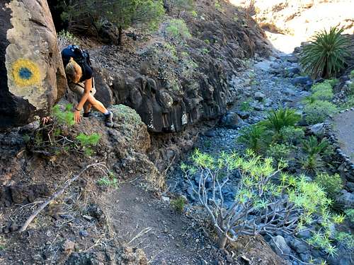
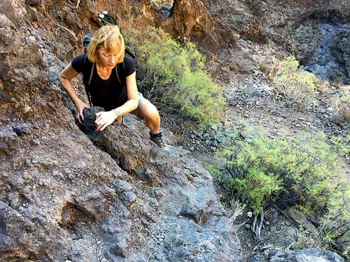
My favourite hike of the trip. Described as possibly the hardest route on the island, I expected us to be in a queue of hikers making the ascent up the steep gorge. The fact we were doing it on a Sunday increased my apprehension that we would be amongst a crowd.
We walked to the old port at Vueltas at 8.15am and onwards along the shore, passing the people sleeping in their campervans at the side of the road, to enter the Barranco at Argayall around 8.45am.
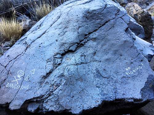
The route started off on a concreted road before following the dry riverbed on a rough path. Deep in the shade of the Barranco, it was cool and quiet. I couldn’t see anyone in front or behind us but I feared that would change. There is an ominous warning near the start of the difficulties – “Dangerous – No Kidding” – and soon after a few testing moves over a short but steep drop to deter any inexperienced holiday makers!
After this, the route scrambles up the loose, right hand side of the Barranco following a poor path.
I’m not going to try to describe the whole route. It traverses from the right back to the riverbed and then up again, rarely straying on to the left hand cliffs.
The route wanders back and forth on very loose ground and the only way to do it is to follow the markers painted onto the rocks at various intervals. My rule became “If I haven’t seen a marker for a while, check I haven’t gone wrong!”
|
|
The route went one way across a cliff, up a little and back above where we had just been. I looked back down the Barranco, still no one was following us.
Now, I understood the warnings in the guidebook – do not try to descend once started, do not attempt in wet weather. It would be easy to go the wrong way descending and any slip would have serious consequences.
After about 1 hour 45 mins, we reached a huge open cave and then emerged into the sunlight. From there, the walking increased and the scrambling decreased, soon we were passing manmade terraces and Palm trees.
We reached the hamlet of Gerian at the top of the Barranco at 11.55 am, just over 3 hours after entering it, a challenging and exhilarating route and on this day, we had it all to ourselves.
It wasn’t over yet though. It was a clear blue-sky day with a cool breeze off of the sea, we still had to get back down.
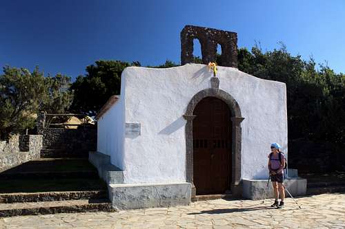
We continued up to the Ermita de Nuestra Senora de Guadalupe – a small chapel sitting in a quiet and serene spot overlooking a fantastic view. A local man sat reading on its terrace. We stopped for some lunch and then continued along the GR132 looking into the upper reaches of the Barranco de Argaga.
|
|
We joined the old water channel and the route across the wild Barranco to return to VGR. We had already traversed this earlier in the trip and then it had been cloudy and looked a bit flat but now it looked fantastic, the Aloe Vera seemed to glow in the sunshine. We stopped near the Degollada del Cerrillal for more photographs and then, reluctantly turned away and down on the steep GR132 into the valley.
The rough path changed to rocky steps.
“It’s not too bad.” Marie called out. “It’s like descending a stairway.”
“Like a Stairway from Heaven.” I replied, subverting the famous song title.
The path assumed that name for the rest of our trip!
A magnificent day in more, perfect weather.
We had changed our plans as the “Calima” was expected. This is a strong, eastern wind that blows sand from the Sahara across the Canary Islands and we weren’t sure what to expect.
The early bus got us to Vallehermoso by 9.30 am, it was a lot warmer now than it had been at the start of the trip. We set off up an easy path in the wide Barranco de la Nouva. We were glad of the shade from the trees and the bamboo and as we got higher, a cooling breeze appeared and then a great view of the Laursilva forest.
We reached the Ermita Santa Clara, another tiny chapel overlooking the cliffs of the north coast and a view across to La Palma. Traversing the beautiful clifftop path and looking out to sea, I was convinced I could see a group of Whales or Dolphins but it was just the wind on the sea causing the whitetops.
We visited the deserted hamlet of Chijere and ate our lunch amongst the ruined buildings. Then, we returned to the clifftop track to pass the Ermita de Coromoto and admire the views of Tenerife through the gathering haze of windblown sand.
Reaching the viewpoint at Montana de Alcala, we rested on the benches to photograph the views of the north coast and debated whether we should retrace our steps back to Vallehermoso or descend from there towards Playa de Vallehermoso. We decided on the latter option and took the steep and unshaded path downhill. The view changed very little as we descended – I think next time I would opt to return the other way.
At the road, we realised we had to re-ascend about a kilometer in distance and about 180m of height to get back to the town. Perhaps this doesn’t sound like much but we had little water left and what we had was lukewarm in the sun and difficult to drink!
By the time we reach the café in the town square we were gasping, the temperature on the local Pharmacy electronic sign showed as 30 C, so we ordered two drinks each with our toastie!
A fantastic cliff walk with a tough ending.
We returned on the bus ok but not everyone was so lucky. Probably around 20 people were left at the bus stops to walk back, hitch a ride or call a taxi!
The following day the main Calima wind struck La Gomera. We stayed inside for most of the day as the wind felled trees and any plants in pots! A small sand dune formed in our room where we had left the French window open for ventilation!
Over the time of the holiday, the memory of the outward journey had faded a little. We were used to part of the bus journey across the island and surely, it wouldn’t be too bad?
We were wrong!
The well-known package tour company we were booked with had put us on a far too early ferry, so we had to leave the hotel at 4.30 am to catch it! We arrived at Tenerife airport at 9.30 am, for the 2.30 pm flight! Subsequently, the flight was delayed for an hour, then 90 minutes more sitting on the runway before leaving for the UK at 5.00 pm. We eventually arrived home just after 10.30 pm, 18 hours after leaving the hotel.
Again, the abiding memory was of the bus journey across La Gomera in the pre-dawn light. Careering around bends, trees flashing by in the headlight beams and fighting motion sickness.
As the bus swooped down into San Sebastian, a woman on the other side of the aisle to Marie and the man sitting behind us both started to vomit into bags they had bought with them. I gritted my teeth and tried to resist the temptation to join them but one thought kept coming back to me….Cherry-Garrard had it easy!
La Gomera - Rother walking guide
Walk! La Gomera - Discovery walking guides
La Gomera and Southern Tenerife - Sunflower Books
La Gomera and El Hierro tour and trail maps - Discovery walking guides