
Comments
No comments posted yet.
|
|
Trip Report |
|---|---|
|
|
28.08939°N / 17.33902°W |
|
|
Mar 7, 2022 |
|
|
Hiking |
|
|
Spring, Winter |
I hear a lot of people say that one should never return to a special place for the fear of being disappointed the second time. Generally, I don’t agree with that sentiment and I enjoy returning to places that are familiar to me and that I like. Some places in the world I have returned to many times and I have had some great experiences time and time again.
The journey to La Gomera from the UK was just as long as it had been two years ago and this time we had the extra frustrations caused by the regulations surrounding the Covid pandemic. On the last trip, we both hated the bus journey from San Sebastian across the island to Valle Gran Rey. The bus driver swooped around the countless hairpin bends and made us feel really queasy. We were pleasantly surprised this time to find the bus was driven slowly and carefully around the bends and the journey featured a stop to “have a breather” after about 30 minutes. We arrived feeling fine, who said “Change is always bad?”
We stayed in the same hotel and it seemed to be quieter at night (good!) but breakfast now started an hour later (bad!) this meant we would have to skip it if we wanted to get the early bus. We could get the later 11.00 am bus some days and finish later. We visited the bus station to find the 11.00 am buses no longer ran and are now at lunch time… never mind, we will cope!
We walked down to the port at Vueltas to find that the road along the coast to the Playa Argaga and the excellent route at the Barranco de Argaga, was now blocked by a sturdy and imposing wire fence with several signs warning the public away. Thank goodness we did that route last time!
(Upon returning to the UK, I found on a website that the road had been subjected to an enormous rock fall – complete with a video of it happening. It has now been closed permanently to the public and it looks like access to the Barranco de Argaga route has probably gone forever.)
Valle Gran Rey was much the same as it was 2 years ago. Although, it seemed quieter and the number of old German hippies living in even older camper vans had been reduced and they were replaced by younger, trendy Spaniards, holidaying in their new motor homes.
Something was different about the beach too, it seemed more crowded but I couldn’t put my finger on what was bugging me.
When we got home and I checked my photos from 2 years before, it became clear. The rough, stony beach is now nearly all sand! Surely that hasn’t happened naturally in just 2 years? Sometime in those 2 years it seems, a decision has been made to attract more families at the expense of the hippies and the walkers.
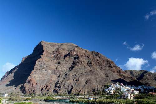
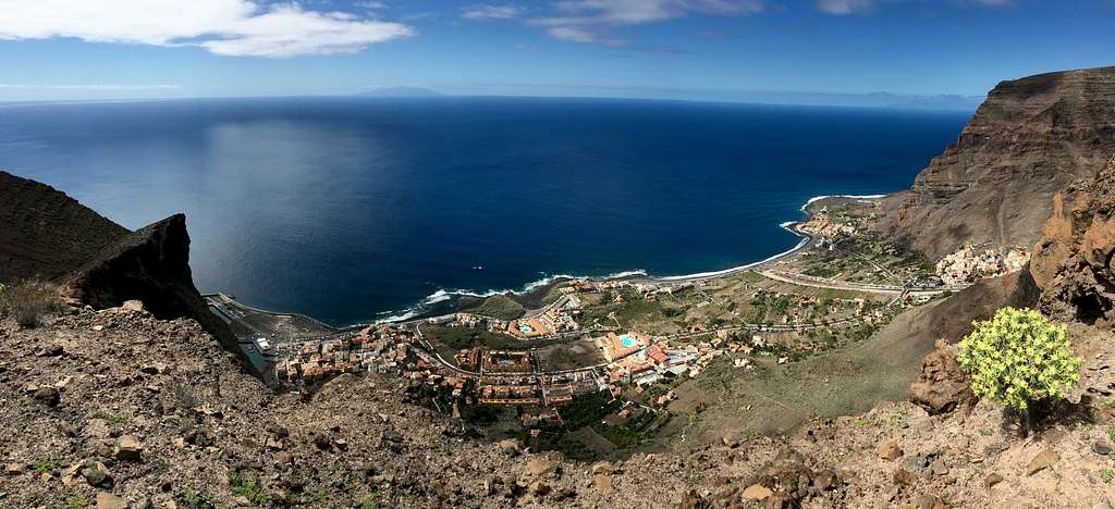
We managed a warmup walk by getting the lunch time bus to Arure and descending La Merica, the volcanic buttress to the west of Valle Gran Rey. We did this 2 years ago but this time we took in the tour of the west side of the plateau. We could look down on the fantastic cliffs only otherwise visible from a boat at sea. Somewhere far below we could hear the cry of a sheep or goat that had wandered down and would probably not find its way back up. Southwards, across the sea we could make out the island of El Hierro, the most southern point of Europe. A lovely way to start the holiday.
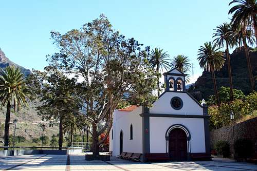
We decided to endure the breakfast bunfight and left the hotel at 9.00 am. We headed uphill to the bus station at La Calera then followed the well-worn trail up the dry valley to the Ermita de Los Reyes. This route had not changed and we had a rest and a drink sitting on one of the shady benches around the Ermita, very pleasant.
After this, we continued along the valley then up the steep GR132 trail that on our last trip we nick named “The Stairway from Heaven”! It was just as steep and the views as we ascended were just as beautiful as we had remembered. It was hot and sunny but we also had some shady parts along the trail and we felt we were going quite well as we arrived at the Degollada del Cerrillal 2 hours and 15 minutes after leaving our hotel.
Having said that, we had been easily overtaken by a very tanned and older, Germanic couple who were carrying nothing but a water bottle each
“That’s how we should be doing it.” Marie remarked as she gestured at our rucksacks.
Somehow, I couldn’t imagine going out into the hills like that!
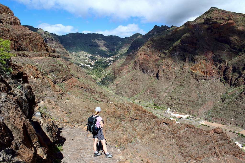
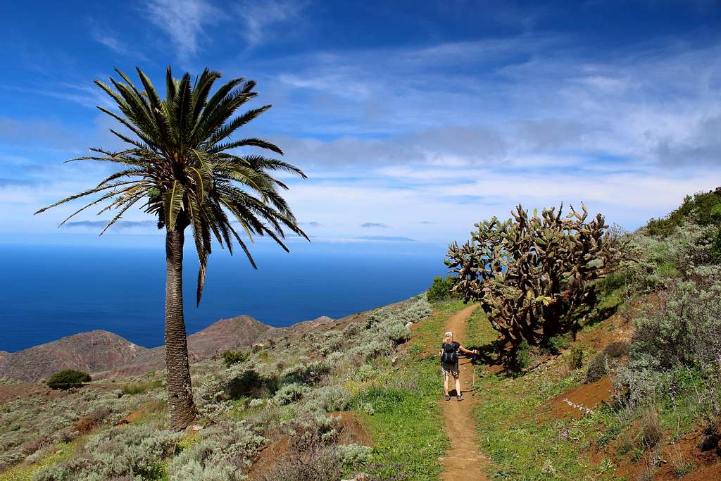
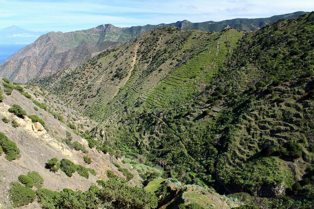
We turned right at the Degollada and headed southwest towards the sea on what was completely new ground for us. I noticed the lonely Ermita de Nuestra Senora de Guadalupe sitting on its buttress across the valley and above the hamlet of Gerian, idyllic in its isolation. The Barranco de Argaga looked beautiful beneath us in the sunshine and in the distance in front of us, the sea shimmered in the heat haze.
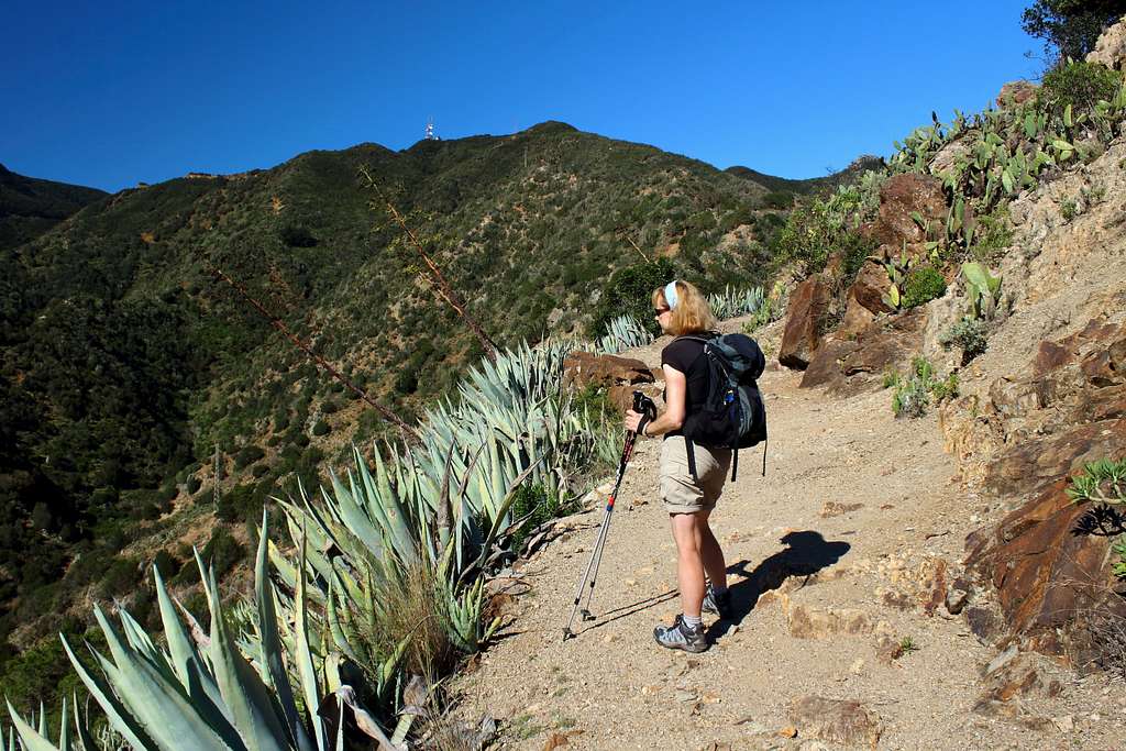
The landscape here is made of red and brown, broken volcanic rock. We continued on the rough, trail around the south side of the Montana del Adivine, threaded our way through the large Agava cacti and the occasional Euphorbia to a dramatic viewpoint over the Degollada de Los Bueyes and the top of Las Pilas farther on.
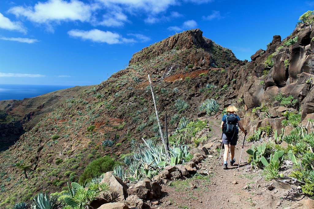
We descended to the Degollada and up the other side on the narrow path. Suddenly, the rather enclosed path opened out and we realised we were coming to the summit of Las Pilas (667m), a small cairn on top of a prominent Basalt “bubble” of rock. Great views out to sea and the distant island of El Hierro and inland the trapezium shaped Fortaleeza stood out.
After a short stop we continued past the derelict farmhouses and descended on a path, if anything, rougher and less distinct than before. The tanned german couple had already turned back, they passed us as we found a way through the sparse vegetation to a saddle. The path reappeared and we found ourselves following a dry-stone wall looking westwards over the sea.
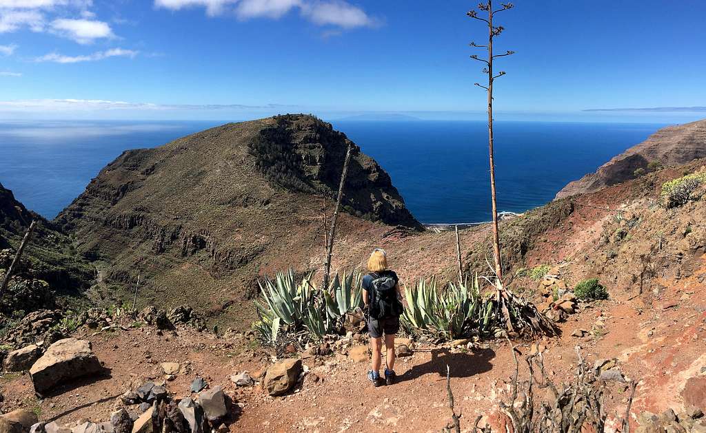
We sat on the wall and ate some lunch, enjoying the views and the warmth. Once we decided to continue, we were surprised to find we got to the viewpoint at Tequergenche very quickly. The cliffs drop around 500m here to the sea and I spent some time capturing the dramatic scenery.
Around 1.00 pm, we set off to retrace our steps past the dry-stone wall and back to the saddle. At this point, we knew a footpath followed the cliff on the west side but we couldn’t see it at first. Gradually we spied a vague way through the rocks and onto the cliffs above Valle Gran Rey.
We had spectacular views down to the old port, the town and our hotel and the steep descent path from La Merica on the other side of the valley. We followed the trail for a while, then headed back towards Las Pilas and found a way to rejoin the trail on the east wide of the mountain.
It was hot work re-tracing our steps in the afternoon sun and it was 3.30 pm before we found our way back to the Degollada del Cerrillal. It took us another hour to descend to the Ermita de Los Reyes – I kept stopping to take photos only to later realise that a lot of them were the exact same views I had taken 2 years before!
A great day out with fabulous views over Valle Gran Rey. Around 12 km long and with height gain and loss of about 800m altogether. A beautiful and surprisingly peaceful part of the island.
We were up early, skipped breakfast and got the bus to the town of Vallehermoso to arrive at 8.45am. We followed other walkers into the café in the town square for a coffee and a chance to study the map and get our bearings. We had visited this area last time but wanted to try a different route up to the scenic northwest of the island.
The long-distance footpath GR 132 was signposted out of the town and onto a sandy ridge. We very quickly made the height as it was a little cloudy and cool but this soon cleared and we were on a sunny trail following the ridge up towards a distant communications aerial on Montana Blanca.
There were no route-finding issues following this route and we were surprised to find we had the whole trail to ourselves. We quickly gained height and reached the road leading to the aerial around 11.30 am. The vegetation had changed from small bushes, through the now familiar Agave and onto the giant Laurisilva ferns that cover the high ridges of the island. Up high it was cool and windy and we descended the ridge overlooking Epina with views of the farms of Alojera and Tazo. This is an area that is famous for producing Palm syrup (Miel de Palma) so has lots of the trees dotted across the slopes.
The views of the northwest coast are beautiful here – we were lucky to be doing this route in now perfect weather - and the island of Las Palmas was a constant draw to the eyes.
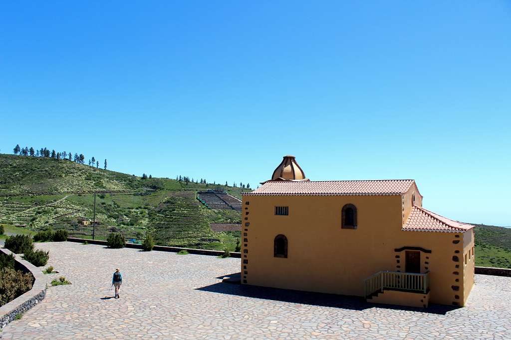
The route turned north, joined a rough road from Epina and soon we reached the beautifully situated Ermita de Santa Clara. We sat in the sun here and watched the black chickens scratching in the dust, then continued following the trail along the top of the Cumbre de Chijere above the sea.
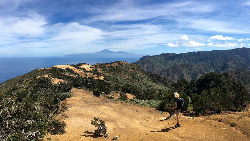
As the route turned further eastwards, we had fantastic views across the sea to Mt Teide on Tenerife. Just before the Ermita de Nuestra Senora de Coromoto, the path re-joined the dusty track from Ermita de Santa Clara and we followed it to the “Buenavista” at Montana de Alcala.
The views here are lovely – this whole area is probably the most beautiful part of La Gomera – and we lingered to enjoy the view perhaps longer than we should have.
“Why don’t we just go back along the ridge to Santa Clara and descend that easy path to Vallehermoso?” Marie asked.
2 years ago, we had walked up the path in the Barranco de la Era Nueva but I wanted to try to descend a different route.
We followed the track until a signpost indicated we descend eastwards towards Vallehermoso, 4.8 Km away via the Barranco de los Guanches. It looked easy so we set off just after 3.00 pm, a couple of women were a little ahead of us, some of the few people we had seen all day.
It wasn’t long before the path deteriorated and became a lot steeper. We slowed down to avoid falling but kept going. Did I mention there was only one bus back to Valle Gran Rey leaving Vallehermoso at 5.00 pm and time was now slipping away?
We caught up to the two women, passed them and didn’t see them again! We hurried on, taking care on the loose ground. Ahead, I could see a path snaking its way across the hillside. Surely, that couldn’t be our path… could it?
It could.
Marie was muttering something about how the other way would have been easier as we descended to a farmhouse, crossed the small river and set off across the hillside, running the flatter parts where we could.
Time ticked on. 4.00pm…4.15pm. I didn’t think we would make it.
Eventually, we rounded the dusty hillside and plunged on and down on yet another rough path towards Vallehermoso, it was hard going.
We got to the bus station in plenty of time (4.40 pm!)
We were tired but it had been a great day and a beautiful route in the rugged northeast part of the island.
The following day, the weather was lovely again but we were so tired, we decided to have a rest. The long-range weather forecast was predicting two days of poor weather at the beginning of the second week but nothing bad. We believed it.
We got the later bus up to Arure, it was quite windy with more of the fluffy white clouds around, a sign of the change in the weather. We found the path up to the viewpoint at Los Barranquillos, it was an ok sort of route. Then, we descended and found the path to the town of Las Hayas and on towards El Cercado.
We had great views of Barranco del Agua and saw many of the local Kestrels wheeling and diving around. From the Bar Maria in El Cercado, we crossed the road and descended the road down the hillside. We were happy the wind was behind us, it battered us and increased as we continued.
Our guidebook described this as “the most beautiful descent route into Valle Gran Rey” and it certainly is spectacular. The road continued but the path descended into the barranco. I looked back to see a wall of cloud towering above us and thought we were in for a soaking but the cloud stayed high and we were looking into the afternoon sun all the way down the exciting switch backed path.
For the next two days, high winds and thick clouds in the mountains kept us close to the hotel. The occasional shower blew through which seemed incongruous in this environment.
The forecast after that was for clear weather but that didn’t happen.
We had an interesting day mostly under a mixture of grey skies and sunny intervals walking from Vallehermoso to the hamlet of El Tion. From here we had a glimpse of Mt Teide, now with fresh snow on its slopes. Then we descended to the reservoir at Las Rosas before returning to Vallehermoso via the Roque El Cano.
We got back up to El Cercado to find it was grey, damp and cloudy, so we descended via La Matanza and back into some warmth.
On another day we walked upwards from Valle Gran Rey on the original descent route from Arure which crossed the main road frequently, just to say we had done it! We visited the now derelict Mirador del Palmarejo restaurant and tried to imagine what it would have been like if we could have afforded to eat there on a sunny evening!
Another late start saw us walking from Arure to the town of Chipude. We started in sunshine but arrived in rain and got the bus back down.
All in all, we did what we could in a period of very unsettled weather. Except in the weather forecast of course, that was mostly full sun!
Somewhere along the way, we agreed that La Gomera had lost a bit of its allure. Was it the poorer weather, the various changes in comparison to our previous visit, the Covid restrictions or our perceived attitude of some of the locals we encountered – they seemed a little unfriendly – it was difficult to say.
On our last day we were promised great weather by the forecast but we found ourselves up at El Cercado again in cloud, drizzle and a strong wind.
We had a coffee in the Bar Maria and decided to walk down but Chipude looked a little brighter.
“Let’s just walk to Chipude and go down from there?” Marie suggested.
We set off, the low cloud scudded across the hillside with occasional glimpses of sunshine. By the time we reached Chipude, the Fortaleeza looked clear, so we continued on. This was a repeat of the route we did in brilliant sunshine 2 years ago.
The cloud started to break up around 10.00 am and by the time we reached the GR131 overlooking Erque, it was sunny and warmer. We walked through a pine forest, the warm sun heating the fallen needles and generating a lovely aromatic scent.
At Igualero, we visited the Ermita at the Mirador de Igualero which we hadn’t seen before. The views were beautiful under the now clear, sunny skies.
We carried on upwards towards the Garajonay, the highest point of the island. The views south and west were clear but as we crested the spine of La Gomera and looked north and east we could only see cloud.
At 1.00 pm we headed west and back towards Chipude. We crossed the fire damaged hillside – burnt in 2012, it is slowly recovering – on and down to Los Manantiales. My memory of this from before was of a long walk but we covered it quickly and by 2.00 pm we were enjoying a Coke and Almond cake on the terrace of the Bar Sonia in Chipude.
At 2.30 pm we set off for the descent down through the Matanza valley. White daises in the grass and Almonds on the trees – we only saw pink blossom before! The Kestrels came out to see us off and as we descended it got warmer. We descended on the GR 132, the “Stairway from Heaven” in t-shirts and shorts and had a final rest stop at the Ermita de los Reyes at 5.10 pm.
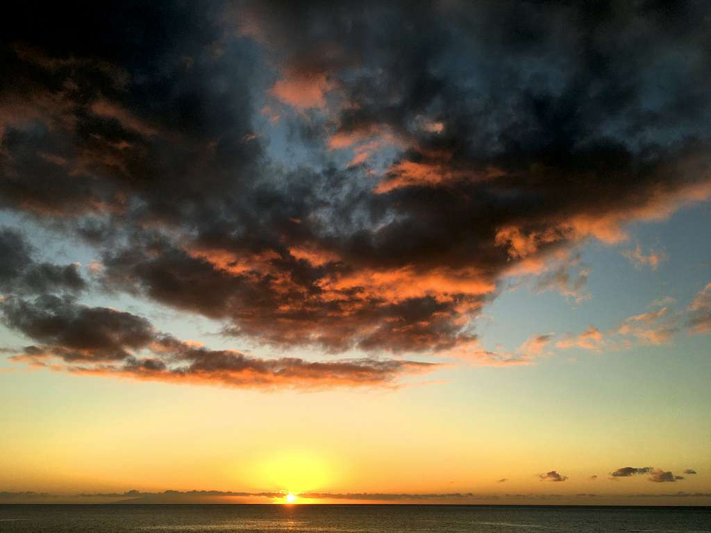
We finished by descending into the setting sun, a really good day to end on.
Everything changes… of course it does. If things were always the same, always predictable, then that would be boring. It is the changes that give us variety. Sometimes the change is good sometimes bad but it is always different.
However, we did leave with a sense of disappointment. We were wondering if we should not have returned so quickly. La Gomera is still beautiful, the walking is still excellent and the weather, when it is good, is lovely. Perhaps on this trip, it was just because it was different from last time that we felt this. Maybe it was the change itself that was the disappointment?