
|
|
Route |
|---|---|
|
|
35.86296°N / 14.56146°E |
|
|
Hiking |
|
|
Spring, Fall, Winter |
|
|
Most of a day |
|
|
Overview
Length approx 17.7km/11 miles
There are many options for coastal walks on Malta and this is one of the best. Whilst the east coast is very built up, the south and west coasts are less so and consequently, a little quieter. Having said that, you will never be far from a road or a house. Malta is quite a barren island and although this is no mountain route, sturdy footwear is recommended.

Spring and Autumn (Fall) are the best times to walk on Malta. In Summer it will be too hot to walk (expect temperatures in the high 30 ‘s C) especially as there is virtually no shade on the rocky coast. Winter can be ok but the weather could be unpredictable, beware of strong winds.
This walk features two of Malta’s picture box fishing villages – Marsaskala and Marsaxlokk – the latter of these is famous for its open-air fish restaurant on the quayside. Whether you have time for a meal or not, it’s worth seeing it on a warm, sunny afternoon.
There are very few signposts on this walk other than some home-made ones and few other markers. Whilst the route follows the coast for the most part care is needed in certain sections. There are no legal rights of way across private land in Malta and access is maintained through the good will of the landowners. Having said that, this is a popular walk and should present few problems.
Getting There and accomodation
Malta is justly famous for its bus services. Frequent and regular services can bring you from wherever you are based to just about anywhere on the island. See the online timetable for more up to date information.
There are plenty of hotels, villas, apartments or campsites throughout the island. Whilst Valletta (the capital) and the east coast just north of Valletta is very busy, virtually all the bus routes go there so travel options increase by way of compensation.
Valletta is very interesting from an historical perspective if you are so inclined.
Route Description
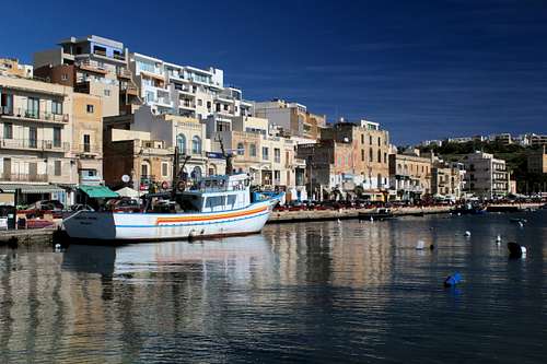
Having found your way to Marsaskala in the south east of Malta, it should be easy to find the seashore. This is obviously a fishing village although, in recent times it has become popular as a holiday retreat for those who can afford one of the sea view plots. Fishermen sell their produce on the quayside and the bay is popular as a destination for divers, something that is true for most of Malta.
Follow the quayside pavement southwards and look down on the salt pans that have been carved in the rock for hundreds of years. Continue around the coast, past Mignuna point and onto St Thomas bay. Up to here, the walk has been on a mix of obvious paths either on the pavement or across the broken rocky shore. As you reach the south side of St Thomas bay, the road peters out into a track and then a path. This path heads out to Il Munxar, a rocky spit of land pointing out into the sea.
(As the road peters out, it’s possible to take a shortcut on the track to cut out Il Munxar but you will miss some of the views!)
Continue on the path to the point for views back to St Thomas bay and onto cliffs above the blue sea.
Take care! It’s worth pointing out that a lot of the cliff edges are undercut by the battering from the elements. Don’t stray too near the edge and risk precipitating a fall.
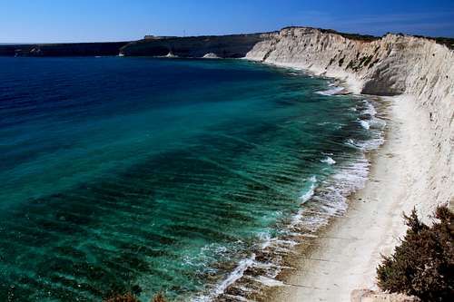
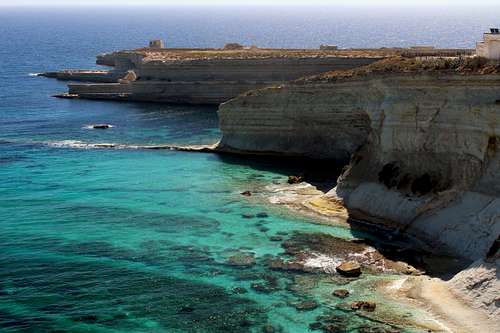
The white cliffs arc around the coast and ahead is the headland of Xrobb il – Ghagin.
Instead of following the cliff top, the track continues onwards across the “neck” of the headland to a junction. On the left here is a chapel dedicated to St Paul. It’s possible to turn left onto the headland and visit the nature reserve there but you will need to return to this spot to continue along the dusty track away from the cliffs.
Continue along the track, passing entrances to private properties until you turn left at the Battery Tas Silg an old fortification to explore the Delimara peninsula. This track now continues between farmers plantations, headlining downwards towards the sea. The track appears to end at the entrances to two properties with “Keep out” signs but an arrow painted on a rock points the way to the path along the cliff top.
You will soon see a beautiful bay marked as Il – Hofra iz- Zghira on the map.
|
|
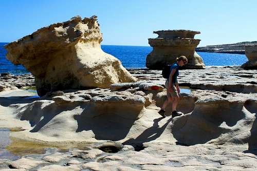
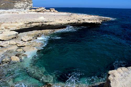
Whilst our path continues along the undercut cliff path, it’s possible to descend to a small beach at this point. The path joins a concrete road and descends to a rocky bay known as St Peter’s Pool.
The rock features here are quite spectacular. The harder limestone at the top of the cliffs had been undercut by the elements as the layers of rock beneath it are a mixture of softer clay and sandstone layers, causing large boulders to fall from the top of the cliffs onto the rocky outcrops below. It’s interesting to explore these features but take care not to linger underneath the crumbling cliffs!
Instead, leave the rocky shore and follow a track parallel to the coastline heading for Tumbrell point. Before reaching the headland, follow the track parallel to the shore but further inland, passing a house above some salt pans defended by several (chained up) barking dogs. Continue along this track to the hamlet of Delimara, a few buildings above a bay.
Here is a junction of several roads and it’s possible to do a loop out to Delimara point along a dusty track.
Ahead is a section where salt pans are carved into the rock and a group of old houses sit on a headland. Don’t make the mistake of following the coast through the salt pans to the houses, you won’t be able to continue from there – guess how I know!
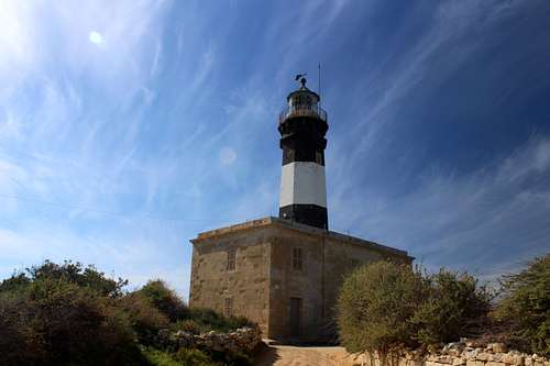
Stay on the track and pass a house on the point itself before returning inland along the track and passing the old Delimara lighthouse, then return to the road junction previously mentioned.
Head north from here along a tarmac road parallel to the sea. On your left and completely incongruously, is a huge tanker, seemingly permanently anchored in the deep-water bay (it is visible on Google Earth!). Unfortunately, your views will be dominated by the docks and power station from here on. Apparently, the Cold War ended here in 1989 when George W Bush and Mikhail Gorbachev held the “Malta summit” on a warship anchored in this bay.
Continue along the tarmac road passing private houses. You are looking for a concrete track on your left heading down towards the bay. A group in front of us turned left down a track but we thought they had turned too soon and continued on.
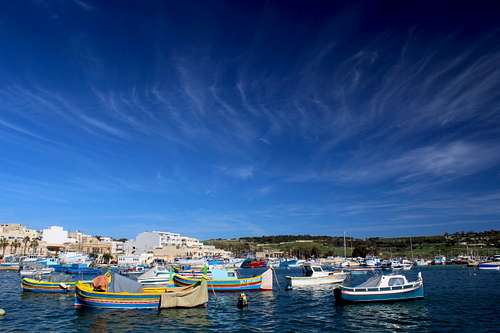
Just before reaching the Battery Tas Silg, turn down a farm track which takes you down to the road just above the bay and from here, turn right and soon left to walk into Marsaxlokk. This is a busy fishing port and on the afternoon we arrived, it was full of coaches bringing tourists to the quayside fish restaurant and market. Thread your way through the crowds and admire the colourful fishing boats (luzzu) in the harbour, the quayside road will take you out of the town.
Join a dirt track and continue around the headland of Il Fossa. Again, the scenery is marred by oil refinery tanks and other industrial buildings along the shore.
Continue towards Fort St Lucian, the historic bastioned watchtower near the headland is rounded and a main road is joined to take you past more oil refinery workings that lead you into Birzebbuga, a quieter town to finish in. Keep a look out for your bus stop along the shore line to take you back to Valetta – the bus arrived as we walked along and we ran to grab it whilst we had the chance.
It’s possible to continue walking for a short way along the coast into the poorly named “Pretty bay” but the ever increasing industrial presence adds nothing to the memory of the coastal walking you have already done.
Essential Gear
Sturdy footwear for the rocky ground, appropriate clothing for the weather including a fleece in case of a cool wind and waterproof in case of rain. A hat, sunglasses and suncream. Water and food.
Map - Kompass No 235 1:25,000 Malta, Gozo
External Links
https://www.publictransport.com.mt/en/timetables