All pictures of this article are by Antonio Giani, om, SalVal & Osw
This ancient tower has a strange location in Aosta Valley, because it can not communicate with other signaling points. Even through the smoke of fires. A good choice is that from the junction on the main road of Moulin (777/65m) after the Municipality of Roisan (
643m; Churches of San Vittore and S.S. Sebastiano, Fabiano), reached also by Senin's Fraction, rather than the San Bernardo there shall Northeast towards Valpelline.
Connection variant: it is also possible to
"bind" the two routes through the return from San Bernardo to the Municipalities of Allein (
1253m; Church of Santo Stefano) and Doues (
1251m; Parish Church) with descent from the latter to Valpelline (
938m; Church of St. Pantaleon). Otherwise from the crossroads of Moulin continuing on Regional Road next to the Torrent Buthier you first reach the village of Rhins (
785m; Château de Rhins. *** Even from here with Road Regional towards Doues) and little ones of Collin, Avillier, Creusevy, Chanodaz, Liarey
(+; 904m) and Valpelline. This valley, in turn, gives two opportunities:
1)- Valpelline just after the junction
1029 metres between Cleyval and Chosoz take toward North Regional Road to Ollomont Commune (
1356m; Parish Church in Cognen; or
2)- continue to Est-northeast reaching Villages Lavod, Berrio, Thoules
(+; 1045m) and the Municipality of Oyace (
1316m; Church of St. Michel), at the foot of the Mountain Chain of Mont Morion and dominated by the
Tour d'Oyace (1477m). The last part of this secluded valley and wild moves towards the Bionaz with the gigantic dam of the same name, also known as the Places de Moulin. Oyace from the Regional Road reaches the Villages of Serignan, Close, Place, Balme (
1515m; Church of Saint-Roch), the Lexert Lake
(1552m) with its small
"Area Naturalistic" Dzovenno (
1564/77m; Church of "Notre Dame des Neiges"; ex ancient copper mine), Perquis and Bionaz
(1622m). From there reaches Ferrère, Chamin, Léchère (
1812m; Church of Saint-Roch) to finish at Place Moulin
(1980m) to West front of the Dam. But it is also possible to completely this big stage in a single day traveling by car all the ways indicated; certainly this choice will go at the expense of a more detailed visit, watching the whole thing
"in passing", but also renouncing to up some short and pleasant walk on foot through the new path that starts from both the Northwest Grenier Fraction than from that of Chez les Brédy in the North. It is advisable to divide it into two parts, making choices. Staying to the cultural aspect, to emphasize the difference between the
Tornalla, former home of the Lords of Quart with large lounge and spiral staircase, from
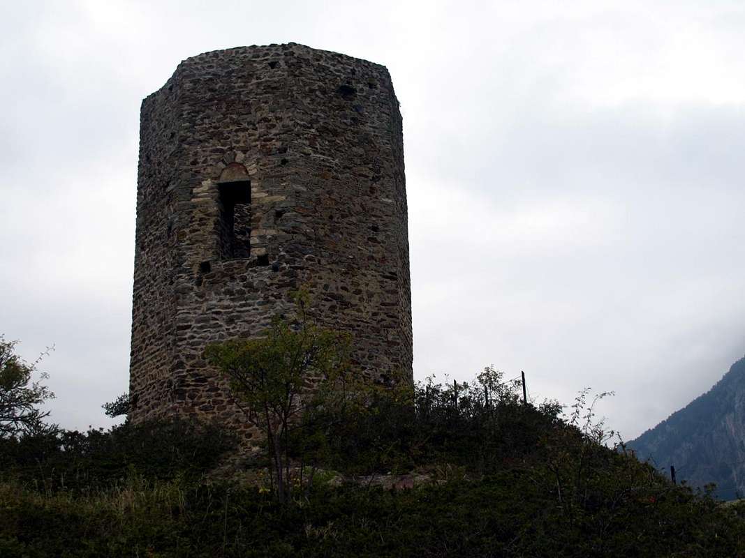
La Tour always old fortified house in 1100 and subsequently amended several times until the Savoy properties until about 1500 years. Inside this building was born Rodolfo de la Tour, Bishop of Aosta Valley. The Oyace Tour rather late built around the year 1300, again by a
Lords of Quart. We have to note that in those days the Central Valley of Baltea was somewhat related, purely commercial purposes, with the adjacent Valpelline through their hills and passes. In it the Lords of Quart held the hearings and the same served as Court of Law. Where to now has remained only the Tour, most likely in times past there was a castle with walls of stone walls, although, actually, the building was protected enough by the surrounding cliffs that plunge to the North towards Oyace and South above the
Buthier de Valpelline. The large tower has a single opening, 7 meters high and facing North; foundations of the tower they should date of 900/950 years. Measuring 5.36 meters in diameter with walls at the base of 1.80 metres. While the Legend gets back to the time of the
Saracens. However, they are only legends, but still handed down from century to century by inhabitants here by forever.
There are several other roads leading in all cardinal directions allowing you to make good discoveries. Of all kinds and for all tastes. Seeing is believing ...
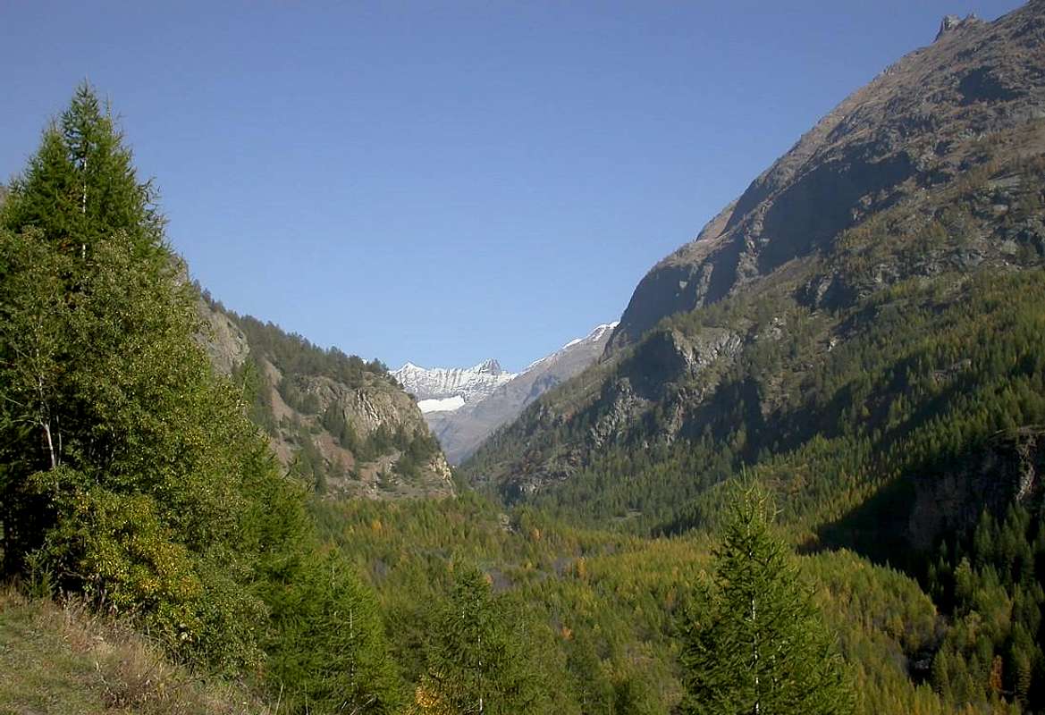
![]() Tall Valpelline Valley from West
Oyace-Voisinal or Crétaz to Tornalla Tower
Quest'antica torre ha una collocazione strana in Valle di Aosta, perché non può comunicare con gli altri punti di segnalazione. Neppure tramite il fumo dei fuochi. Una buona scelta consiste che dal bivio sulla Statale di Moulin (777/65 m) dopo il Comune di Roisan (643 m; Chiese di San Vittore e S.S. Sebastiano e Fabiano), raggiungibile anche dalla Frazione di Senin a St. Christophe ed appena sopra Aosta, invece che per il San Bernardo si proceda a Nordest verso la Valpelline. Variante di collegamento: inoltre é possibile "legare" i due itinerari passando al ritorno dal San Bernardo per i Comuni di Allein (1253 m; Chiesa di Santo Stefano) e di Doues (1251 m; Chiesa Parrocchiale) con discesa da questo ultimo sempre a Valpelline (938 m; Chiesa di St.-Pantaléon). Altrimenti dal bivio di Moulin continuando sulla Strada Regionale a fianco del Torrent Buthier si raggiunge dapprima il Villaggio di Rhins, appena oltre il ponte sopra il Rio Artanavaz o Buthier des Bosses che quivi si riunisce al precedente (785 m; Château de Rhins. *** Anche da qui Strada Regionale per Doues) e poi quelli di Collin, Avillier, Creusevy, Chanodaz, Liarey (+; 904 m) e Valpelline. Questa valle, a sua volta, concede due opportunità: 1)- subito dopo Valpelline al bivio 1029 metri tra Cleyval e Chosoz prendere verso Nord la Strada Regionale per Ollomont (1356 m; Chiesa Parrocchiale a Cognen; oppure 2)- continuare verso Est-nordest raggiungendo i Villaggi di Lavod, Berrio, Thoules (+; 1045 m) ed il Comune di Oyace (1316 m; Chiesa di St. Michel), ai piedi della Catena del Mont Morion e sovrastato dalla Tour d'Oyace (1477 m). L'ultima parte di questa valle isolata e selvaggia si indirizza verso il Comune di Bionaz con la mastodontica omonima Diga, conosciuta anche con il nome di Place Moulin o, meglio, Places de Moulin. Da Oyace la Strada Regionale raggiunge i Villaggi di Serignan, Close, Place, Balme (1515 m; Chiesa di Saint-Roch, il Lago Lexert (1552 m) con la sua piccola "Area Naturalistica", Dzovenno (1564/77 m; Chiesa di "Notre Dame des Neiges"; ex Miniera di rame), Perquis e Bionaz (1622 m); da qui raggiunge Ferrère, Chamin, Léchère (1812 m; Chiesa di Saint-Roch) per terminare a Place Moulin (1980 m) al fronte Occidentale della Diga. Ma é anche possibile effettuare completamente questo tappone in un'unica giornata percorrendo in auto tutte le vie indicate; certamente questa scelta andrà a discapito di una visita più approfondita, osservando il tutto "en passant", ma soprattutto rinunciando a qualche breve e simpatica passeggiatina a piedi col nuovo sentiero che parte sia dalla Frazione di Grenier a Nordovest che da quella di Chez les Brédy a Settentrione. Restando all'aspetto culturale, da sottolineare la differenza che esiste tra La Tornalla, vecchia dimora dei Signori di Quart con grande salone e scala a chiocciola, da La Tour sempre vecchia casaforte del 1100, ed in seguito varie volte modificata, di proprietà di Casa Savoia fino al 1500 circa. In essa i Signori di Quart tenevano le udienze e la stessa fungeva da Tribunale. All'interno di questo edificio era nato Rodolfo de la Tour, Vescovo della Valle di Aosta. La Tour di Oyace invece fù costruita intorno all'anno 1300, sempre da un Signore di Quart. Dobbiamo fare notare che a quei tempi la Valle Centrale della Dora Baltea era alquanto connessa, a scopi prettamente commerciali, con l'adiacente Valpelline tramite i relativi colli. Dove oggi é rimasta esclusivamente la Tour, molto probabilmente nei tempi passati esisteva un castello con la cinta di mura in pietra, anche se, per la verità, l'edificio era già abbastanza protetto dai circostanti dirupi che precipitano a Settentrione verso Oyace ed a Meridione al di sopra del qui turbolento Buthier de Valpelline. La grande torre presenta un'unica apertura, alta 7 metri e rivolta a Nord; le fondamenta dell'antica torre invece dovrebbero datare degli anni tra 900 e 950. Misura 5,36 metri di diametro con muratura alla base di 1,80 metri. Mentre la Leggenda la fà risalire al tempo dei Saraceni. Comunque sono esclusivamente Leggende, ma pur sempre tramandate di secolo in secolo dalla popolazione qui residente pressocché da sempre.
E comunque esistono diverse altre strade che conducono in tutte le direzioni cardinali permettendo di fare belle scoperte. Di ogni tipo e proprio per tutti i gusti ...
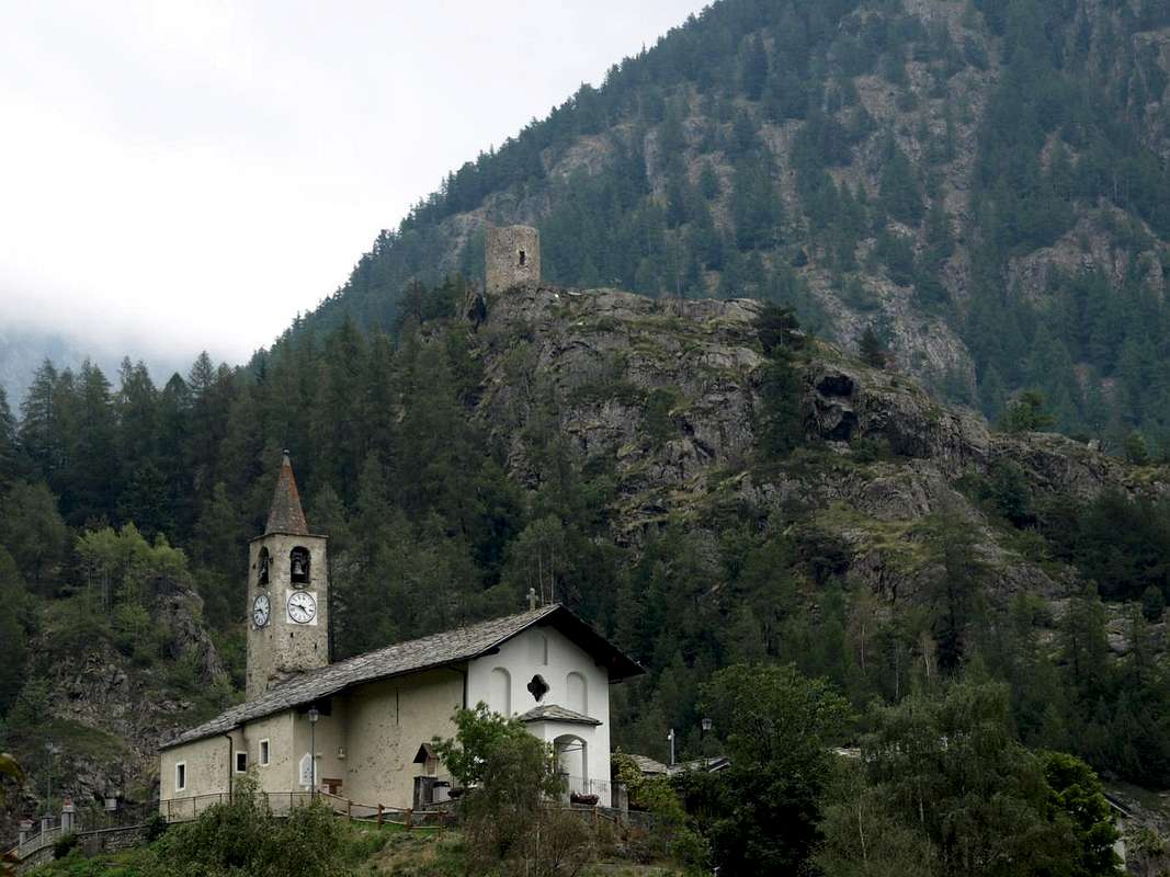
Northwestern entrance towards the Tour de la Tornalla
Tall Valpelline Valley from West
Oyace-Voisinal or Crétaz to Tornalla Tower
Quest'antica torre ha una collocazione strana in Valle di Aosta, perché non può comunicare con gli altri punti di segnalazione. Neppure tramite il fumo dei fuochi. Una buona scelta consiste che dal bivio sulla Statale di Moulin (777/65 m) dopo il Comune di Roisan (643 m; Chiese di San Vittore e S.S. Sebastiano e Fabiano), raggiungibile anche dalla Frazione di Senin a St. Christophe ed appena sopra Aosta, invece che per il San Bernardo si proceda a Nordest verso la Valpelline. Variante di collegamento: inoltre é possibile "legare" i due itinerari passando al ritorno dal San Bernardo per i Comuni di Allein (1253 m; Chiesa di Santo Stefano) e di Doues (1251 m; Chiesa Parrocchiale) con discesa da questo ultimo sempre a Valpelline (938 m; Chiesa di St.-Pantaléon). Altrimenti dal bivio di Moulin continuando sulla Strada Regionale a fianco del Torrent Buthier si raggiunge dapprima il Villaggio di Rhins, appena oltre il ponte sopra il Rio Artanavaz o Buthier des Bosses che quivi si riunisce al precedente (785 m; Château de Rhins. *** Anche da qui Strada Regionale per Doues) e poi quelli di Collin, Avillier, Creusevy, Chanodaz, Liarey (+; 904 m) e Valpelline. Questa valle, a sua volta, concede due opportunità: 1)- subito dopo Valpelline al bivio 1029 metri tra Cleyval e Chosoz prendere verso Nord la Strada Regionale per Ollomont (1356 m; Chiesa Parrocchiale a Cognen; oppure 2)- continuare verso Est-nordest raggiungendo i Villaggi di Lavod, Berrio, Thoules (+; 1045 m) ed il Comune di Oyace (1316 m; Chiesa di St. Michel), ai piedi della Catena del Mont Morion e sovrastato dalla Tour d'Oyace (1477 m). L'ultima parte di questa valle isolata e selvaggia si indirizza verso il Comune di Bionaz con la mastodontica omonima Diga, conosciuta anche con il nome di Place Moulin o, meglio, Places de Moulin. Da Oyace la Strada Regionale raggiunge i Villaggi di Serignan, Close, Place, Balme (1515 m; Chiesa di Saint-Roch, il Lago Lexert (1552 m) con la sua piccola "Area Naturalistica", Dzovenno (1564/77 m; Chiesa di "Notre Dame des Neiges"; ex Miniera di rame), Perquis e Bionaz (1622 m); da qui raggiunge Ferrère, Chamin, Léchère (1812 m; Chiesa di Saint-Roch) per terminare a Place Moulin (1980 m) al fronte Occidentale della Diga. Ma é anche possibile effettuare completamente questo tappone in un'unica giornata percorrendo in auto tutte le vie indicate; certamente questa scelta andrà a discapito di una visita più approfondita, osservando il tutto "en passant", ma soprattutto rinunciando a qualche breve e simpatica passeggiatina a piedi col nuovo sentiero che parte sia dalla Frazione di Grenier a Nordovest che da quella di Chez les Brédy a Settentrione. Restando all'aspetto culturale, da sottolineare la differenza che esiste tra La Tornalla, vecchia dimora dei Signori di Quart con grande salone e scala a chiocciola, da La Tour sempre vecchia casaforte del 1100, ed in seguito varie volte modificata, di proprietà di Casa Savoia fino al 1500 circa. In essa i Signori di Quart tenevano le udienze e la stessa fungeva da Tribunale. All'interno di questo edificio era nato Rodolfo de la Tour, Vescovo della Valle di Aosta. La Tour di Oyace invece fù costruita intorno all'anno 1300, sempre da un Signore di Quart. Dobbiamo fare notare che a quei tempi la Valle Centrale della Dora Baltea era alquanto connessa, a scopi prettamente commerciali, con l'adiacente Valpelline tramite i relativi colli. Dove oggi é rimasta esclusivamente la Tour, molto probabilmente nei tempi passati esisteva un castello con la cinta di mura in pietra, anche se, per la verità, l'edificio era già abbastanza protetto dai circostanti dirupi che precipitano a Settentrione verso Oyace ed a Meridione al di sopra del qui turbolento Buthier de Valpelline. La grande torre presenta un'unica apertura, alta 7 metri e rivolta a Nord; le fondamenta dell'antica torre invece dovrebbero datare degli anni tra 900 e 950. Misura 5,36 metri di diametro con muratura alla base di 1,80 metri. Mentre la Leggenda la fà risalire al tempo dei Saraceni. Comunque sono esclusivamente Leggende, ma pur sempre tramandate di secolo in secolo dalla popolazione qui residente pressocché da sempre.
E comunque esistono diverse altre strade che conducono in tutte le direzioni cardinali permettendo di fare belle scoperte. Di ogni tipo e proprio per tutti i gusti ...
Northwestern entrance towards the Tour de la Tornalla
![]()
Getting There from Aosta towards Oyace
By car:
- From TORINO, MILANO, etc: Motorway A5. Exit at IVREA or Quincinetto (PIEDMONT)
From IVREA Town: before in West to Aosta, after in Northwest to Gignod, Etroubles, Saint-Oyen, Saint Rhémy en Bosses, (Southwestern and Northwestern Sides) and in North to Allein, Doues, Valpelline (Northeastern Side) Municipalities.
![]() By Roisan fork among Etroubles, Ollomont & Valpelline
By Roisan fork among Etroubles, Ollomont & Valpelline
From
Courmayeur Resort: before in East to Aosta, after in Northwest to Gignod and in North to Allain, Doues, Valpelline and Ollomont Municipalities.
![]() Valley of three Buthiers
Valley of three Buthiers
From Aosta towards Valpelline, by this Oyace and Bionaz Communes in Valpelline Valley
From
Aosta City towards the crossroads before
Gignod Commune and from this last to
Valpelline (580m), alwayswith Regional, to
Oyace Common (1316-1377m); this to North and South Vallons (Brison, Crête Sèche, Vertsan, Tsa Comba, Grand Chamin Comba, Comba des Lacs and d'Orein up to the entrance into the vallon between Gran Vanna-Braoulé-Bouquetins and Petite/Grande Murailles, below Valpelline Pass.
From
Oyace (1377m), with Regional Road, to
Bionaz Commune (1612m) and Places Moulin artificial Dam
(1970/80m) and Northern and Southern Vallons (Bella Tsa, Combes de Valcornière, Livourneaz, Montagnayes; Vessonaz, Verdonaz, Vieille, Verdzignolaz, Arpisson, Gran Comba and Roisan-Praperiaz Basin.
In North: above Ruz
Crêtes Sèches Refuge (2389m) under Arolletta small crest and Mont Berlon and
Franco Spataro Bivouac (2600m); above Chamen or Chamin
Sassa's Bivouac (2973m). From Praz Raye with the
Prarayer Refuge (2005m) in Comba d'Orein
Nacamouli Refuge (2828m) and
Col Collon Bivouac (2818m) at Collon Pass. Towards
North: "Capanna" Aosta (2788) at Dent d'Hèrens;
North-northeast: Perelli Bivouac (3831m) on Col des Grandes Murailles.
East-northeast: Bivouac de la Tête des Roèses (3170m) below the Grandes Murailles and over
Paoluccio Bivouac (3582m).
East: Fiorio Bivouac (3307m) at Col de Creton. From Oyace or from Valpelline
In South or Southeast: Lière Bivouac (2423m) nearby the Arpeyssaou Hill. Valpelline
in South-southeast: "Penne Nere" Bivouac (2730m) near Viou Hill and Becca.
- From FRANCE: through the Mont Blanc Tunnel to Entrèves-crossroads to Vény/Ferret Valleys - Mountain Guides of Courmayeur - La Saxe Rock Gym - Courmayeur. By Little Saint Bernard Pass, closed since November until half May to La Thuile Valley - Pré Saint Didier - Courmayeur.
It is not necessary to take Motorway A5: you can drive on State Road n° 26, in the direction of AOSTA - IVREA - TURIN.
By plane:
- Aeroporto Internazionale "Corrado Gex" Saint Christophe (Aosta).
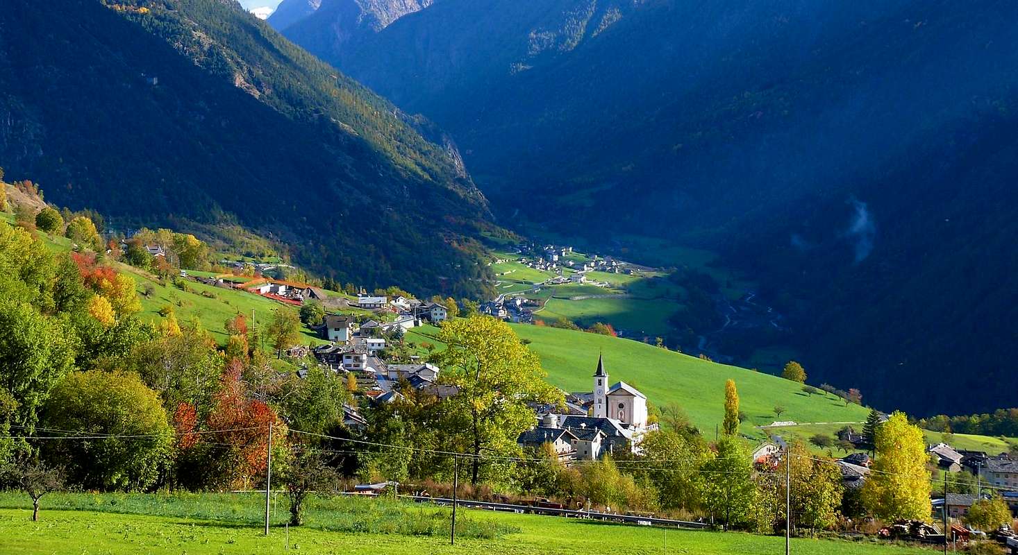
![]() Valpelline Commune at beginning of wild & green Val Pelline
Valpelline Commune at beginning of wild & green Val Pelline
One beautiful walk above the Buthier de Valpelline with Betenda's Bridge
![]() A small Trip to the Tour de la Tornalla the XII° Century
A small Trip to the Tour de la Tornalla the XII° Century
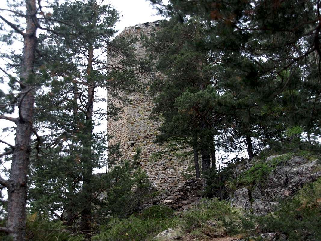
From small Villages Voisinal, Grenier, and Crétaz Serignan you can reach with a short walk this Tower "holed up" on the above-wooded rocky promontory.
A first trail
n° 3 starts by Grenier-Vernoce Fraction (1257m), addressed first to the East, then Northeast and across the Bois
"Les Crêtes" reaches the Tornalla's Tower on its West side. The second, also well marked with signs in brown, always starts as
n° 3 by the Village of Serignan-Chez les Bredy
(1385m), soon after the Church of St. Michel and Crétaz Fraction, and begins the ascent to the East for then fall back strongly in the South. At the junction with the trail, down towards the underlying Betenda Bridge above the Buthier de Valpelline, turn sharply to the right (West) and drive past some small basins reaching a fence in a protective timber. A final more steep section and exposed to the South, by means of some steps on the rocky plates, leads to the Tour de la Tornalla, which is reached on its Eastern side (
T/F; 0h'30). Currently at the start and at the
"Bouc Plan" is under construction a direct variant that runs along the Northern side of the interior of the forest of
"Plan Bouc". In any case, be very careful when children are present, since the grassy-rocky promontory summit, with some wooden benches on the side West, is very scenic but also very exposed on all sides, especially to the South and West.
![]() Una piccola Gita alla Tour de la Tornalla del XII° Secolo
Una piccola Gita alla Tour de la Tornalla del XII° Secolo
Da Voisinal, Grenier, Crétaz e Serignan si può raggiungere con breve camminata questa Tour
"asserragliata" sul soprastante promontorio boschivo-roccioso.
Un primo sentiero
n° 3 parte da Grenier-Vernoce
(1257 m), rivolto dapprima ad Est e poi Nordest ed attraverso il Bois
"les Crêtes" raggiunge la Tour sul suo lato Occidentale.
Il secondo, anche esso ben segnalato con cartelli in marron, parte sempre come
n° 3 dal Villaggio di Serignan-Chez les Bredy
(1385 m), subito dopo la Chiesa di St. Michel e Crétaz, e inizia la salita verso Est per poi ripiegare decisamente a Mezzogiorno. Al bivio con il sentiero per il Ponte della Betenda svoltare decisamente a destra (Ovest) ed oltrepassate alcune piccole conche raggiungere una staccionata in legno protettiva. Un ultimo tratto più ripido ed esposto a Sud conduce, per mezzo di alcuni gradinamenti sulle placche rocciose, alla Tour de la Tornalla, che si raggiunge sul suo lato Orientale (
T/F; 0h'30). Attualmente nella parte iniziale e presso il
"Plan Bouc" é in fase di costruzione una variante diretta percorrente il lato Settentrionale all'interno della Foresta del
"Plan Bouc". In ogni caso prestare molta attenzione in presenza di bambini, poiché il promontorio erboso-roccioso sommitale, con alcune panche in legno sul fianco Ovest, risulta molto panoramico ma anche alquanto esposto su ogni lato, soprattutto a Sud e ad Occidente.
![]()
Comments
No comments posted yet.