
-
 2541 Hits
-
 71.06% Score
-
 1 Votes
|
|
Route |
|---|---|
|
|
40.07290°N / 20.90986°E |
|
|
Download GPX » View Route on Map |
|
|
Hiking, Mountaineering |
|
|
Spring, Summer, Fall, Winter |
|
|
Half a day |
|
|
Class 3 |
|
|
II |
|
|
Overview
This is the shortest possible route to summit Mt Smolikas, you can use the forest service road to drive up to 2000m of elevation and hike the rest 700m of elevation. Be wary though, the road is only open when the snow has melted and the route is not perfect whilst the snows are melting as you will have to cross 2 creeks and multiple water exit points on the steeper sections. More on this on the hazard chapter.
Getting There
To reach the village of Pades you must either reach the city of Konitsa or the city of Grevena. From the city of Grevena you will have to drive towards the Vasilitsa ski centre and then follow the winding bad condition mountain road to the village of Pades. The road might not open during large storm cycles. The drive is long and in all honesty unpleasant as f**k, preferably drive slowly and be patient.
Route Description
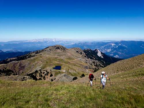
The route is a beautiful mid-length easy hike. It is easy relative to the fact that Smolikas is the second-highest mountain in Greece. The route begins in the low meadows at 2000m of elevation near an area called 'Stani' where there are sheep, from there you can see and follow the well-marked trail up to Drakolimni at 2200m. The trail up to that point is not steep and is on wide well designated and well-carved trail, be wary that in a couple of points we got lost (for around 20m out of the trail but we found it again) and at some points, it is exposed and crosses dry creek beds.
After reaching Drakolmni (after about 1 hour) you will have to climb the remaining 500m of elevation, this section is steeper and more exposed. The first parts are switchbacks on badly corroded gravel and steep terrain so be wary; then after a large creekbed crossing, where you cross the outflow (the beginning) of a river, where the snowpack melts to. This section is very exposed and does not have marks for the trail. If you are hiking and there is snow there try to hike up the snow rather then traversing especially if it is during May, June where the snow melts. From there you will hike the generally steep trail on the lush green fields under the summit. From car to summit it took around 3 hours and about 2 hours to get back, including breaks (which we took plenty).
 High on Smolikas
Essential Gear
It depends on the season but, be sure to pack water as there are no springs, and if you attempt the route during the winter months you will definitely need crampons and an ice axe. Be sure to pack hiking poles and some snacks as it is quite a long hike.Hazards
As I stated in the beginning there are plenty of hazards on the route. Note that the route requires multiple creek crossing that might not be possible during Spring and early Summer (it was fine when we went during the last days of July) also some of the exposed sections would be impossible with snow so be sure to know how to properly re-route if you attempt during the winter months.