

-
 23613 Hits
-
 77.26% Score
-
 8 Votes
|
|
Mountain/Rock |
|---|---|
|
|
40.08962°N / 20.92588°E |
|
|
Ioannina |
|
|
Hiking, Mountaineering, Skiing |
|
|
Spring, Summer, Fall, Winter |
|
|
8652 ft / 2637 m |
|
|
Overview
Smolikas (2,637m) [“Σμόλικας”] is the second highest mountain in Greece after Olympus (2,917m) and is located in the Northern reaches of the Pindos Mountain Range, making it the range’s highest summit. It is surrounded by rivers and all sides, with the Aoos (Vjosa) river passing through its South, forming the Valley of Aoos, and separating it from the nearby mountain of Timfi (2,497m). It is situated in a high precipitation area leading to its lush forests of Oak and Pine, and is home to several villages including Samarina ["Σαμαρινα"], built at 1,1515m making it the second highest one in the country.
The mountain encompasses more than 20,000ha, mostly forested in Black and Bosnian Pine, and Oak, and is very remote, thus, acting as a refuge for local animal populations of bears, wolves, and wildcats. The biodiversity of the region is staggering, more than 120 species of bird, 40 mammals, 30 reptiles, and hundreds of plants call the slopes of the mountain their home. This plethora of animal life, wood, and water attracted human habitation for millennia, however, the cold and rouged conditions of winter were not for the weak. Even today, the lack of snow-removal during the winter leads to closure of roads between villages, thus, residents often live in nearby cities during winter.
History & Area Guide
The mountain of Smolikas is generally unexplored historically but its post-roman history is known through the traditions of the Vlachs, with Smolikas being one of their strongholds in Northern Pindos – alongside Tzoumerka and Grammos. On it Northeast is the head village of Samarina located at a maximum (cited) altitude of 1,515m – making it the second highest in the country. The location played host to a settlement of Neanderthals c. 70,000 years ago, while further evidence of human settlement arises from Levallois-technique Paleolithic (c. 50k ya) tools and Neolithic (c. 10th century BC) buildings. The recorded history of the village starts around the 16th century, referred as “Santa Maria de Praitoria”, while the earliest mention of the modern “Samarina” is made in 1819 on a monastery plaque. The village was primarily inhabited by Vlachs who engaged in animal husbandry and logging, while women are known for producing woven blankets and other thick fabrics. Before becoming a unified village is was made up of several smaller farmsteads (Katounes), the most notable of which being Ag. Paraskeui in which residents stayed year-round. Today residents also rely on tourism, with the village seeing more than 7,000 visitors during the August 15th holidays. Notable sights in the village include the churches and monasteries with Ag. Paraskeui being the oldest; also, the Vasilitsa Ski Center is located 15km to the East of the village, however, it is on Mt. Vasilitsa and not Smolikas.
|

|
|
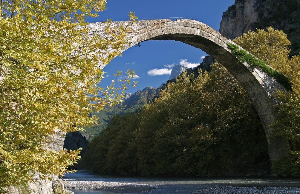
On the South the mountain is separated from Timfi (2,497m) by the gorge of Aoos river which starts at Distrato and descends to Konitsa ("Κονιτσα"), it has a number of traditional stone-arched-bridges throughout, while its final section (usually starting from Konitsa), is a somewhat popular hiking area. Although shadowed by the gorge of Vikos a few kilometers South, home to Voidomatis river, this area is arguably both lusher and more biodiverse than it. Aoos and its tributaries in this area are home to populations of Trout and Briána. There are also several waterfalls, some which can be swam in, around the different ravines connecting Smolikas to Aoos.
At the edge of the village of Pades on the South of the mountain, is the "Stontzi" ("Στοντζι"), a vertical rockface within the forest which has a number of marked climbing routes. The longest route is 40m and classified as a 7b ("Tsarlaman").
Getting There
The main villages and at each side of the mountain are Palioselli (S) and Samarina (N), directions to here are provided through Google Maps links. There are many other villages around the mountain to explore or stay at. The one nearest the access road on the South is Pades.
From nearby Konitsa or Grevena to the villages, the road is not very well maintained, and there are potholes, rocks, and tortoises (!) on the road. In good weather the drive from Konitsa to Palioselli is about an hour. While from Grevena it is about 2 hours.
During the winter access to Samarina is easier since roads to the village are cleared of snow and well paved.
From Greece
Smolikas is located in the Northwest of Greece near Grevena (“Γρεβενα”), nearly a 6-hour drive from Athens. Here is how to reach the two main villages from nearby Greek cities with airports.
- Athens
- Thessaloniki
- Ioannina
From Albania
Smolikas is nearby the Greek-Albanian border crossing of Konitsa, it is thus easy to visit and hike (or ski) in combination with mountains in the South of Albania. Directions follow:
Trailhead Access
There are six villages which give access to the mountain, three on the South and three on the North. Some of the villages have trails starting from their bounds, while others have access roads which go much higher. The access roads require a 4x4 and can be in questionable or outright unknown condition.
Route(s)
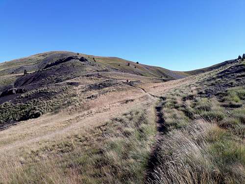
The mountain features an extensive system of trails that pass through almost all the high peaks of the mountain. The trails start as we said from six or seven villages, the trails are of variable difficulty, and most can be climbed year-round. There are technically seven different summit routes so:
From Palioselli
Normal Route Palioselli (South Face) – Route Page - Thomas Gurviez.
Starting from the village of Palioselli this route follows the main trail O3. It passes by the refuges at 1,750m and then links into the shoulder trail below the Dragonlake.
Distance: 9.6km (one-way)
Duration:
Elevation Gain: 1,700m
Difficulty: Medium
From Pades (Pades Normal)
Pades Normal – Route Page – The_Cat_Guy
Starting from Pades village this route meets with the O3 trail under the peak of Mougkourida (2,080m). It is possible to drive up the access roads and cut out about 4-5km from the route.
Distance: 13.3km to 8.3km (one-way) [depends on access road use]
Duration:
Elevation Gain: 1,500m
Difficulty: Easy
From Armata (via Mosia Traverse)
Starting from Armata village this is the longest route on the South face, it takes you over Mosia () and the exposed “crater” and summit ridge of the mountain.
Distance: 15km (one-way)
Duration:
Elevation Gain: 1,820m
Difficulty: Hard
From Samarina (East Ridge + Mosia)
Starting from inside the village of Samarina the trail takes one up through a birch forest on the NE and continues via the East Ridge – the only trail to do so. It heads to the summit of Mosia (2,530m) before meeting the trail from Armata and doing the Mosia Traverse towards the Smolikas summit.
Distance: 13.5k
Duration:
Elevation Gain: 1,820m
Difficulty: Hard
From Ag. Paraskeui (North Face)
From the village of Ag. Paraskeui, this trail is the most direct on the North face of the mountain and follows a couple of ravines up the slopes.
Distance: 9km (one-way)
Duration:
Elevation Gain: 1,602m
Difficulty: Medium
From Pournia
From the village of Pournia, this trail is the longest, it tackles the North face from below the summit of Kleftis (1,846m) before traversing West to East passing Misoraxi (2,227m) and meeting the O3 trail.
Distance: 14.3km (one-way)
Duration:
Elevation Gain: 2,900m
Difficulty: Hard
List of Highest Peaks
[Will add]
When to Climb
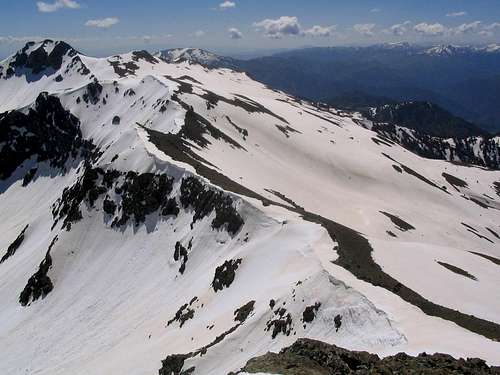
Smolikas is in one of the wettest locations in the country and has its own microclimate. It has a lot of low-slung peaks with vegetation and is boxed in by mountains on all sides. For hikers it is recommended to attempt in July and August. Temperatures should be up to 25C in the valley and the lack of rain will make road access near guaranteed. For mountaineers and skiers, it is best to attempt from late-March to May, road access should be ok and the snowpack more stable.
"In late May 2006 it was still possible to ski from 1800 meters on north sloped and 2000 meters on south slopes... -Thomas Gurviez"
Huts & Camping
Smolikas Refuge
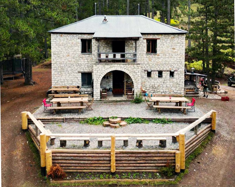
The Smolikas Refuge is maintained and operated just above the village of Palioselli at an elevation of 1,750m on “La Nane” place. It can accommodate up to 24 people in 4 rooms – in bunks – and has a dining room, kitchen, bathrooms, and showers with hot water. There is also electricity, supplied by a generator. The is open from May to November given there is not too much snow. For bookings contact them on Facebook or Instagram.
While it is unclear if the refuge operated in the winter, they are also operators of the nearby emergency hut, which might be able to be opened upon request during the winter months.
Camping
Like usually in Greece, wild camping is allowed, however, it is strongly discouraged on this mountain. Other than extreme weather visitors may have to deal with wildlife (including wolves and bears) and be nearly inaccessible to rescuers – especially in winter. Furthermore, the unique environmental health of the region can be put at risk by excessive camping. Thus, camping is only recommended to those looking to conduct through-hikes and are very experienced.
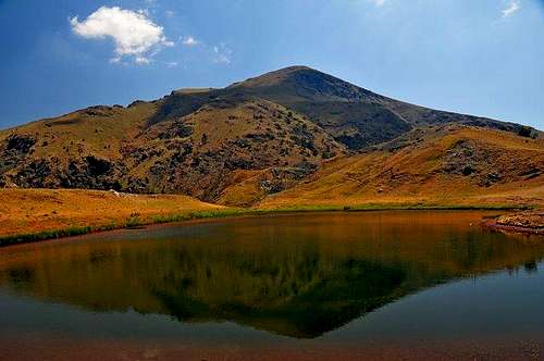
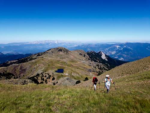
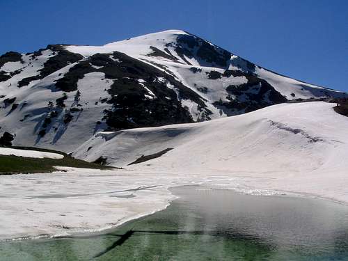
Dragonlake of Smolikas (Lyga)
Smolikas is home to Greece’s second highest alpine lake, the Smolikas Dragonlake (Lyga) on the West shoulder, and an elevation of 2,150m. The lake is about 375 steps in perimeter, being rather deep and shaped like a heart. Its shores showcase the red dirt of the mountain while from elevation it looks a blinding blue. At the Western edge of the lake the tree trails meet to travel to the summit.
|

|
|
The lake has gotten its name from the Alpine Newts (Triturus alpestris) which live in its waters, one of 4 such alpine lakes in the country. These are semiaquatic Salamanders of about 8-12cm in length which live in both permanent and temporary bodies of water in the alpine and sub-alpine. They are considered “Least Concern” but have seen local extinction. They feed on invertebrates and themselves may fall prey to dragonfly larvae, large beetles, fish, snakes, birds, or mammals.
Natura 2000 (et. al.)
The mountain is classified as a Natura 2000 protected site, in fact one of the oldest in Greece, established in 1996, and protecting 52 species of animals and 10 habitats. Covering 20,000ha and elevations from as low as 500m to as high as 2,637m, its main inhabitants are birds and plants. There are 48 species of protected birds including Kingfishers, Horned Owls, and Striped Woodpeckers. There is one species of protected fish, the Briana, one protected mammal, the Otter, and one protected amphibian, the Macedonian Newt. Additionally, it is home to forests of Birch, Beech, and the endangered Macedonian Oak. Find out more on the Natura 2000 viewer.

|

|

|
This area is considered as a “Important Area for Birds in Greece” by the Hellenic Ornithologic Society (HOS), an according to their data is (was?) home to Eagles, Egyptian vultures and Wallcreepers among others. Find out more about the rare birds potentially living here from the HOS site-page.
It is also notable that Smolikas is within the known territory for Brown Bears and Wolves as well as, supposedly, home to Eurasian Lynx.
Backcountry Skiing & Snowboarding
Due to its plentiful snowfall and relatively easy access up to Samarina, especially during late spring, the mountain is a popular destination for experienced backcountry riders. The terrain of the mountain is usually quite conducive to ski mountaineering but is vast and has several steep and exposed sections, especially in its upper reaches. In late winter and early spring, it is common for riders to tackle the North approach from Samarina; in good conditions this may entail skiing through the birch forest. Later in spring it becomes possible, and easier, to approach from the South. Attempting later in the season might confine one to the upper reaches of the mountain.
In 2016 the annual Snow Leopard Day ski mountaineering event took place on the mountain, based out of Samarina, summiting Mosia (2,530m).
Learn more about Backcountry Skiing & Snowboarding in Smolikas
- Lost Ski on Smolikas, Frozen Ambrosia, 2017, Blog Post.
- Smolikas - Ski tour through a wintry primeval landscape, Chillaz, 2022, Trip Report.
- A Line in the Snow, Ben Tibbetts, 2017, Youtube.
- Freeride Skiing in Greece Mt Smolikas, TeoGrevena2249, 2011, Youtube.