
|
|
Area/Range |
|---|---|
|
|
40.46576°N / 7.55173°W |
|
|
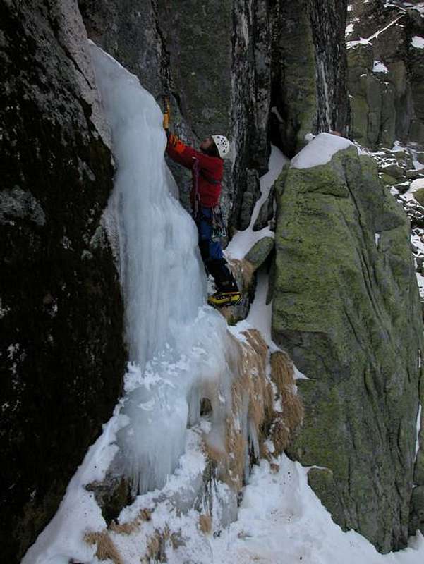
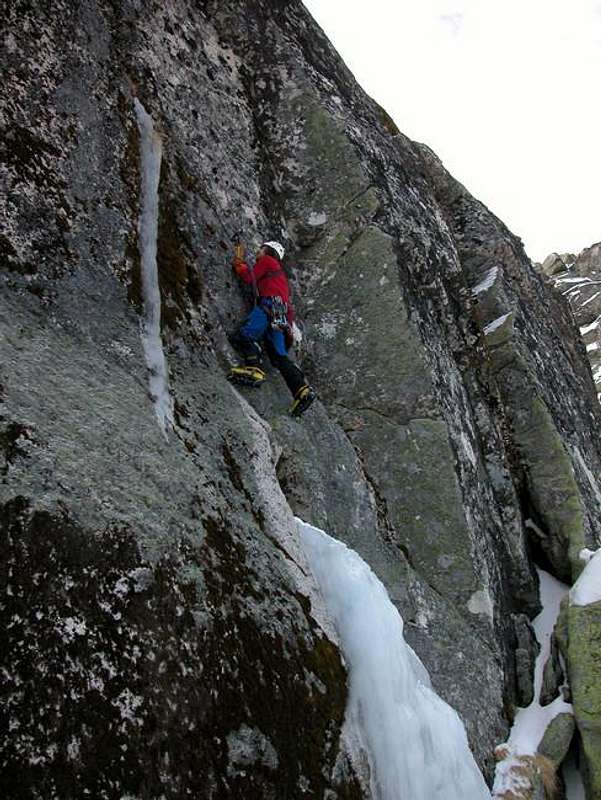
Hiking, Mountaineering, Trad Climbing, Scrambling, Canyoneering, Skiing |
|
|
Spring, Summer, Fall, Winter |
|
|
6552 ft / 1997 m |
|
|
Overview
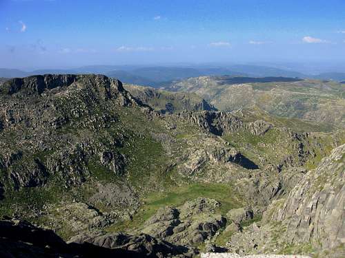 View from the highest point in Portugal... View from the highest point in Portugal... |
Serra da Estrela means something like 'mountain range of the stars'. Well, the name on it's own should already make one curious of what this area offers and looks like. When you think about Portugal you would not immediately think about summitpost material. All tourists, well at least most of them, are here to visit the beaches and enjoy the sun. The more adventurous people might know about this area though. Located somewhat in the north-east of Portugal is the one 'real' mountain range of the country: Serra da Estrela. Estrela is home to the highest mountains of the mainland of the country. The highest peak of the country lies on the Azores islands, being officially part of Portugal.
The highest point of Estrela is just 3 meters short of the 2000 meter barrier, with 'Torre' at 1997meter being the highest point of Portugal's mainland.
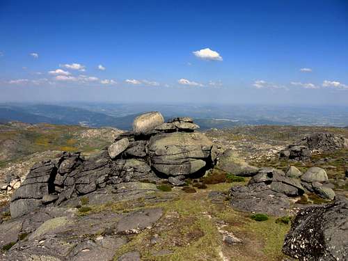
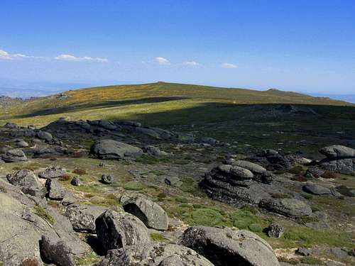
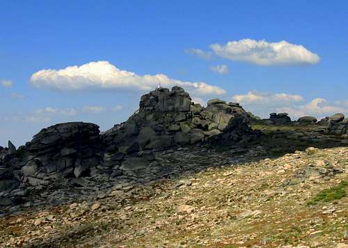
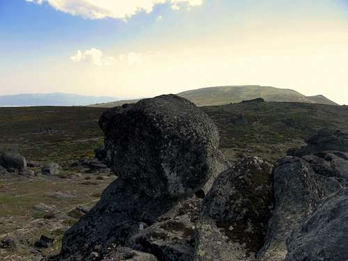
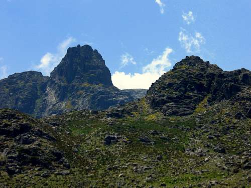
Visiting Estrela when getting the change is a must for every nature / mountain lover. The area consists of old glacial valleys, peaks with heavily eroded Paleozoic rocks as well as some impressive, steep peaks with Cantaro Magro as the prime example.
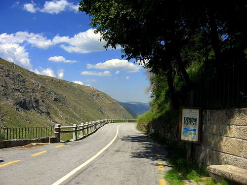
Because of these features Estrela is a place for every type of nature lover: Steep peaks like Cantaro Magro are a challenge for every climber, there are many marked trails for hikers and for the less active people it might be interesting that the highest point of Portugal's mainland (which is actually a plateau) can be reached by car. A small paved road passes trough the entire region end finds it's way up to the 1997 meters high Torre. Estrela is just one of those places that has something to offer to any person who visits!
A Moby Dick Legend
A legend associated with Serra da Estrela is mentioned in chapter 41 of the American literary classic, Moby-Dick:
"...the prodigies related in old times of the inland Strello mountain in Portugal (near whose top there was said to be a lake in which the wrecks of ships floated up to the surface)..."
 Typical Estrela Typical Estrela |
 Colors Colors |
Main Mountains
1) Curral da Nave (1457m)
Peak that can be easily climbed. No marked route leads there, but no gear is needed to get to the summit, good walking shoes and a topographical Estrela Map are sufficient.2) Poios Brancos (1704m)
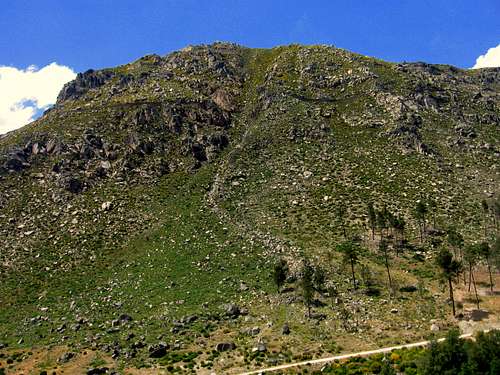
Nice outlook peak for the Estrela region. From the summit you have a fantastic view over the Zezere valley and over the highest Estrela (and Portugals) mountains. You can see for example Cantaro Raso, Cantaro Magro and the highest point of Portugals main land: Torre. Poios Brancos is a ''hiking peak''. The actual summit is a large, heavily eroded granite outcrop. There is some scrambling involved to reach the actual summit, but actual climbing involved here. Good walking shoes and a topographical Estrela Map are sufficient to access this mountain.
 |
 |
 |
3) Alto da Pedrice (1759m)
Peak that can be easily climbed. No marked route leads there, but no gear is needed to get to the summit, good walking shoes and a topographical Estrela Map are sufficient.4) Navo de Sanio (1541m)
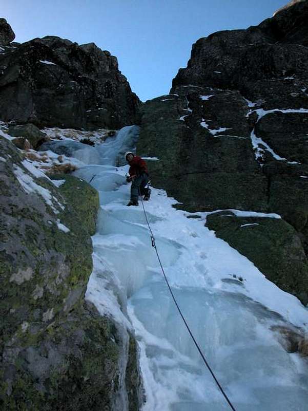
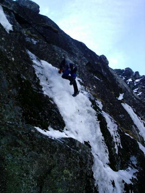
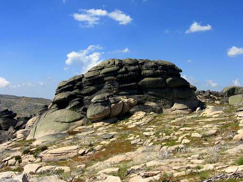
Peak that can be easily climbed. No marked route leads there, but no gear is needed to get to the summit, good walking shoes and a topographical Estrela Map are sufficient.5) Cantaro Magro (1928m)
Cantaro Magro is the ideal peak for the real climbers amongst us. There are several routes leading to the summit. Climbing experience and gear are essential. For more information about this peak see the SP page of Cantaro Magro.
 |
 |
 |
 |
6) Torre (1997m)
The highest peak of the mainland of Portugal offers great views over the Estrela mountains and over the rest of Portugal. On clear days you can see as far as 100 kilometers. The sad part is that a paved road leads up to Torre, so you can reach it by car. Well, some of you might like this, but personally I think it is quite sad. Nonetheless Torre is also reachable for hikers, no specific gear needed, just some good hiking shoes.
 |
 |
 |
7) Cantaro Raso (1916m)
Cantaro Raso also is a nice destination for the 'real' climbers amongst us. It is the smaller brother of Cantaro Magro but offers some nice routes to the summit. Unfortunately I have no detailed information about this climb. If you want to climb this peak I suggest you get your information by one of the Tourist Offices of the Estrela National Park (adresses given below on this page).Facts
A-Estrela is home to many water springs, waterfalls and rivers. The result is that one of the biggest natural water brands of Portugal finds it's origin in Serra da EstrelaB-Serra da Estrela is home to Portugal's only ski area (!) A chairlift goes up to the upper plateau at 1997 meters where in winter there is a skiing possibility. In my personal opinion it is a shame: The perfect view from the highest point of Portugal gets severely damaged by this lift. But of course there will be many people who enjoy it.
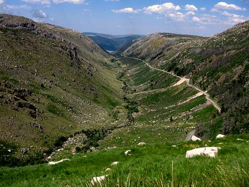
C-Some years ago (2004/2005) The main valley (ancient glacial valley) which is called 'Zezere' was completely burned down. All vegetation was burned down and the story goes that the valley was completely black.... During my visit in 2008, the area recovered well, it was completely green again, fortunately!
D-The Serra da Estrela Dog (Cão da Serra da Estrela) is a breed of mountain dog that takes its name from this region.
-Queijo Serra da Estrela (Serra da Estrela cheese) is a cheese from the region of Serra da Estrela.
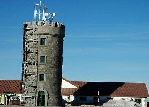
E- The Torre, 1993m is the highest peak on Portugal's main land. Dom João VI built a tower here in the early 19th century in order to extend the mountain to a more acceptable 2000m, becasue he was unsatisfied with it's height.
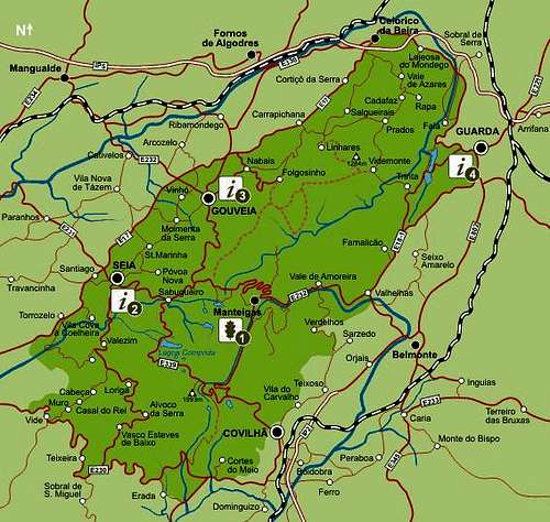
Overview Map of Serra da Estrela National Park
Geography

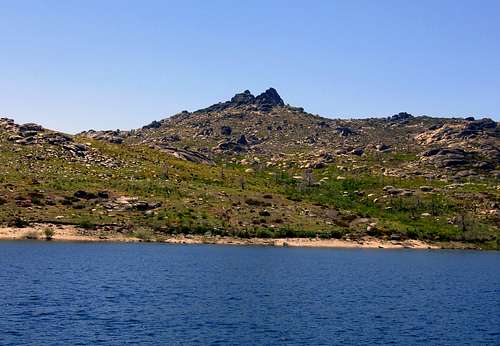
Estrela Dam

Zezere Valley
Officially, the highest peak of Portugal is Pico mountain, which is located on the Azores islands. If the Azores islands are not included though, the highest mountain of Portugal is Torre, with an elevation of 1997 meters the highest point of Serra da Estrela and Portugal's mainland.
The main municipalities of this National Park are Seia and Covilha, which is the biggest town in this area.
The Serra da Estrela region is located in the North-Eastern part Portugal, with a distance of 300 Km of Lisbon, 200 Km of Porto and 400Km of Madrid.
The Serra da Estrela region is located in the North-Eastern part Portugal, with a distance of 300 Km of Lisbon, 200 Km of Porto and 400Km of Madrid.
Geology

Rock versus Houses

Granite formation

Poios brancos

Poisos Brancos summit
The older deposits disappeared, as a result these granite layers came at the surface. While time continued the mouintain area eroded more and more. Then, 65 million years ago it came once again to a clash of the continents. The African continent moved north towards Eurasia. As a result the Pyrrennees formed at the border of what is now France and Spain. But this was not the only mountain range formed. Also older mountain ranges where pushed up once again, one of them is Serra da Estrela.
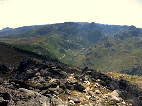
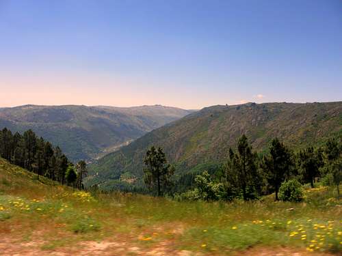
During the Glacial ages the top of the Estrela massive was covered by a thick ice layer: an ice cap was formed on the Tower Plateau, which had a surface area of around 70km2 and a thickness of 80m. In all directions the ice was pudhed down by the force of gravity creating all kinds of glacial valleys. A prime example is the extremely straight glacial valley of the Zezere.
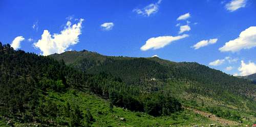
After the last glacial age all snow and ice disappeared. What was left is high mountaineous plateau coverd with pine forest. Due to deforestation and agriculture the present landscape arised: Beautiful rock formations with heavily polished granite blocks surrounded by grassy areas. These formations once again surrounded by ancient glacial valleys and high steep peaks (like for example Cantaro Magro)
Climate

Magro

Estrela Lake
The climate is also seen as a special one: At the end of the 19th century Estrela was seen as the perfect place to recover from Tuberculoses, in those days Public Enemy number one. From that moment on, multiple Sanatoria where build in the area and still exist in present day.
Flora and Fauna

Flora Colours

Burned Tree
Estrela is a National Park and also a Bature reserve, it therefore is home to many animals. Much places are cultivated, but still many animal species can be found. You could spot Bore, Foxes or wild cats in the region. The Iberian wolf was also an inhabitant of Estrela, but unfortunately he lost the unfair batte with the sheep farmers and therefore is now extinct in this part of the world.
A special animal that does still exist in this area is the Lacerta monticola monticola, the Iberian mountain Lizard. Estrela is the only place in the world where this animal lives free in nature. Furthermore, many bird species like owls and also snakes and rats can be seen here.
Economy
Polos Brancos
The road....
Within the territory of the Serra da Estrela National Park, over 40.000 people inhabit the region. Most of these people live of agriculture and lately also of tourism. Another special fenomena is the breeding of dogs. The 'Cão da Serra da Estrela' is a very wanted dog in Portugal and is bred here in Estrela. Next this there are some barrier lakes in the areas where drinking water is made and electricity is generated. From the once blooming wool industry is not much left.
Visitors Centres / Tourist Information
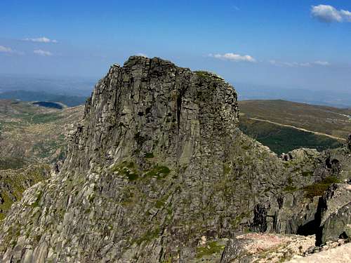 Beautiful Cantaro Magro Beautiful Cantaro Magro |
The Information Offices offer a wide range of information and leaflets including the books with English language called: "Discovering Serra da Estrela" and "Estrela: A Natural Approach".
The "Discovering Serra da Estrela" is the most complete guide to the hiking trails that have been marked for the entire National Park. There are three main routes,namely: T1, T2 and T3 and then six additional routes that split off from the main routes: T11, T12, T13, T14, T31 and T32. In total this accounts for a 357 kilometer network of hiking trails. Estrela therefore offers the biggest network of hiking trails compared to any other National Park in Portugal.
There is also a visitors guide called "Guia de sensibilizacao do visitante da Serra da Estrela",it is only available in Portuguese but it does have lots of maps with symbols and the hiking trails marked on it, so you can gain a little understanding if you do not speak the Portugese language.
The bigger part of the people at the Natural Park offices speak English. The ones that do not, are very helpfull as well.
 Ancient Glacial Valley Ancient Glacial Valley |
 Colorful view Colorful view |
 Cantaro Magro Cantaro Magro |
These are the adresses of the Estrela visitors Centres (locations shown on the map!):
1) Rua 1º de Maio, 2
6260-101 MANTEIGAS
Tel.: (351) 275 980060/1
Fax: (351) 275 980069
e-mail: pnse@icn.pt
2) Pr. da República, 28
6270-496 SEIA
Tel.: (351) 238 310 440
Fax. (351) 238 310 441
3) Casa da Torre, Av. Bombeiros Voluntários, 8
6290-520 GOUVEIA
Tel.: (351) 238 492 411
Fax. (351) 238 494 183
4) R. D. Sancho I, 3
6300-548 GUARDA
Tel.: (351) 271 225 454
Hiking & Hiking Trails
 Houses and Rocks Houses and Rocks |
Estrela Plateau |
The Serra da Estrela is the only region in Portugal to boast a network of marked routes, which cover the whole of the National Park. There are three main trails present. These trails are named T1, T2 and T3.
Each of these trails takes between three to four days to complete; they are considered overall to be moderately difficult to difficult walking, because there are some steep hikes involved and long distances have to be covered. Of course it is possible to follow just shorter sections of each trail. Furthermore there are six side trails, namely T11, T12, T13, T14, T31 and T32.
But if you want to follow a trail for only one day, starting and ending at the same place, there are 2 routes present: The Manteigas-walk starts at the Pousada near Manteigas, by following a part of one of the main trails and then making a wonderful loop around the plateau by returning via another main trail, which leads you trough the Vale do Rossim on the way back.
The Azinheira-walk is in a forgotten corner of the park on the bank of the Beijames River. This beautiful watershed is lined with traditional stone and wooden houses, built in a loosely common architectural style that melds perfectly with its surroundings. There's a circular walk around the valley, which goes up to the waterfalls of Poço do Inferno and to the peak of Azinheira (1035m). For more information about the starting points of all these routes see the paragraph 'Visitors Centre/Tourist information' At these visitors centres there are many leaflets with all infromation you need for hiking along one of the beautiful trails.
 Estrela Lake Estrela Lake |
 Typical eroded rocks Typical eroded rocks |
A proposed day trip by www.quintadoriodao.com is as follows:
The trip is starting and ending at Quinta do Rio Dão - Santa Comba Dão:
• Take the IC12 highway to Nelas and then turn to Seia (approximate 55 minutes from Santa Comba Dão) where the Serra da Estrela begins.
• Take the road to S. Romão (3 km) and than go into the mountains. At only 1 km from S.Romão lies Senhora do Desterro, a sanctuary with its chapels and centenary oaks.
• Continuo the road, always climbing, passing the Logoa Cumprida ("Long Lake") up to the top called Torre.Leave the Torre and the ski-lifts behind and turn to Manteigas on a beautiful road with spectacular views.
• If you want to do the Azinheira-walk, turn right, along the border of the river Zézere, passing Sameiro and Vale de Amoreira, until Valhelhas, where the walk starts.
• Then return to Manteigas. From Manteigas go up in direction of Gouveia / Seia.
• If you want to do the Manteigas-walk, park at the Pousada of Manteigas where the walk starts.
• Half way Manteigas -Gouveia turn to the left, to Sabugueira and Seia (good restaurant in Seia: Camelo e Camelo). Than back to Santa Comba Dão via Nelas.
Maps and Practical Information
 Wonderful colours of Zezere Valley Wonderful colours of Zezere Valley |
When you head out in Serra da Estrela it is very recommended that you are in the posession of a good topographical map of the area. The tourist information centres offer a 1:50.000 Carta Turistica Sreea da Estrela map. Other options are:
1:50,000 Gouveia 17D,
Guarda 18C and/or Covilha 20C maps,
the 1:10,000 Viseu Fl17, Guarda Fl18, Covilha fl20,
or the 1:200,000 Beiras Fl14 maps.
These are available from the Instituto Geografico e Cadastral in Lisbon or regional offices in Porto, Castelo Branco and Coimbra.
Furthermore, the weather in Estrela can change very rapidly. So for these reasons: Buy yourself a map before you head out!
And still Covilha is one of the major wool producing centers in Europe.
Back in the Middle Age Covilhã was one of the main towns in the kingdom, further enhanced by the fact that some important people born in the city itself or in the surrounding district were determining personalities in all the major discoveries made in the fifteenth and sixteenth centuries: crossing the Atlantic, the sea route to India, the discovery of America and Brazil, the first voyage to circumnavigate the globe.
Last but not least, Covilha therefore is a great place to stay when you are planning to climb or hike in the Estrela mountains. It has a rich culture and many hotels to stay. The distance to the Estrela park is less then 10 km so easy to reach by car or bus.
The history of Manteigas dates from the pre-Christian era, but its first charter was granted in 1188 by King Sancho I. Obvious Typical shepherds jackets, wood carvings, tin work, sheep-skin items and granite carving are also among handicrafts that are a reflection of the past. Other flavours from the past and the mountains can be savoured in the roast kid, mountain style stew, bean stew trout, smoked sausages, whey cheese, Serra cheese, milk cakes and Crista cakes, "cavacas" (a kind of hard, sweet cake or biscuit) and "queijadas" (type of cheese-cake).
If you are planning a trip to Estrela and you want to be 'in the mountains' then Manteigas is the right place. Hiking trails start within the village and the main mountains are within a reach of 5 kilometers.
Guarda 18C and/or Covilha 20C maps,
the 1:10,000 Viseu Fl17, Guarda Fl18, Covilha fl20,
or the 1:200,000 Beiras Fl14 maps.
These are available from the Instituto Geografico e Cadastral in Lisbon or regional offices in Porto, Castelo Branco and Coimbra.
Furthermore, the weather in Estrela can change very rapidly. So for these reasons: Buy yourself a map before you head out!
The main Towns: Covilha and Manteigas
COVILHA
Covilha is the centre of the regional tourism in the area. It is located to the south-east of Serra da Estrela and is home to 50.000 inhabitants. Furthermore, it is one of Portugal's major cities. The city differs in elevation from 400meters at it's lowest point until 850 meters at it's highest point. The city has lived on the wool industry for over 800 years.And still Covilha is one of the major wool producing centers in Europe.
Back in the Middle Age Covilhã was one of the main towns in the kingdom, further enhanced by the fact that some important people born in the city itself or in the surrounding district were determining personalities in all the major discoveries made in the fifteenth and sixteenth centuries: crossing the Atlantic, the sea route to India, the discovery of America and Brazil, the first voyage to circumnavigate the globe.
Last but not least, Covilha therefore is a great place to stay when you are planning to climb or hike in the Estrela mountains. It has a rich culture and many hotels to stay. The distance to the Estrela park is less then 10 km so easy to reach by car or bus.
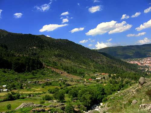
MANTEIGAS
Manteigas is a smaller town in comparison with Covilha. It is located inside the Estrela Park and therefore closer to the mountains. It is located at an altitude of 700 meters at the end of the famous Zezere valley, which is an ancient, extremely straight, glacial valley. From this mountain town you have great views over the Estrela mountains.The history of Manteigas dates from the pre-Christian era, but its first charter was granted in 1188 by King Sancho I. Obvious Typical shepherds jackets, wood carvings, tin work, sheep-skin items and granite carving are also among handicrafts that are a reflection of the past. Other flavours from the past and the mountains can be savoured in the roast kid, mountain style stew, bean stew trout, smoked sausages, whey cheese, Serra cheese, milk cakes and Crista cakes, "cavacas" (a kind of hard, sweet cake or biscuit) and "queijadas" (type of cheese-cake).
If you are planning a trip to Estrela and you want to be 'in the mountains' then Manteigas is the right place. Hiking trails start within the village and the main mountains are within a reach of 5 kilometers.

Manteigas
How to get there
Access Routes
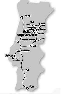
The A25 highway when you are coming from Porto
THe A1 and IC 16 when you are coming from Lisbon
The A2 and A23 when you are coming from Faro
The A23 when you are coming from Spain
Distances:
Lisboa – Manteigas: 315 km (3h45)
Porto – Manteigas: 200 km (2h50)
Coimbra - Manteigas: 131 Km (2h10)
Faro – Manteigas: 548 km (5h45)
Vilar Formoso - Manteigas: 105 Km (1h30)