
-
 1893 Hits
-
 70.83% Score
-
 1 Votes
|
|
Mountain/Rock |
|---|---|
|
|
38.01219°N / 23.76310°E |
|
|
Mixed |
|
|
Fall |
|
|
1066 ft / 325 m |
|
|
Overview
This rock is the highest point on the Phsyxiko plateau rising 325m high, it ranks at the hardest rock climb in the area and it offers amazing views of the area. The rock features three distinct ridges and multiple steep faces, most of them unclimbable; being a hard and outstanding summit it stands still unclimbed.
Getting There
Summit(s)
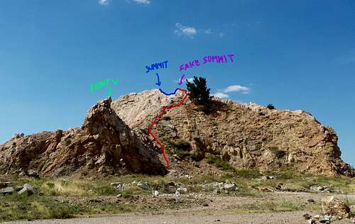
There are three 'peaks' on the mountain with point A (320 m), point 315 (315 m), Point V (31? m).
This was the highest point i reached during my expedition. This is the second summit accompanied by a tree and situated at the E most point of the rock. It is part of the standard route to summit and is still higher in comparison to other neighboring rocks.Point V
This point is a high almost 8-10m high rock from the base that is on the south ridge (part of the standard route), it is still unsummited and requires high rock climbing expertise. Built from red rock and packed dirt it is a dangerous endeavor to climb with or without equipment. The altitude of the summit is unknown so get out there and reach it.The fake summit is point 315, on red you can see the route.
Routes
I used the south route to attempt the summit. As after trying all the East faces and the SE ridge we ended up using the S ridge to make the attempt. Even the S ridge has a very large level of difficulty.
South Ridge
The entrance of the south ridge route is at (38.011777, 23.763243) and continues northbound until the ridge top is reached. At this position you should be about 10m N of Point V rock and should continue N pressing up towards the tree (should be on the right). Its time for the hard scarmbe part, at this point you should have reached the crux rock. This is a step rock you should push up this section and leave the tree to be on the right and behind. At this point you rached point 315 and have to cross the knife edge ridge that runs across point 315 and point A, this is undoubtably the most dangerous part since then drops on either side are about 20 m and the only thing that can stop you is the ground. Stay safe.
When to Climb
It is a perfect all-weather summit to climb just don't even bother if there is any rain. Most of the rock is red rock and sand and so water really destroys the hill and can take you to the ground.
Icehunter - Apr 10, 2022 7:55 am - Voted 9/10
Altitude of the 2 highest peaksI believe that the highest peak in the whole area is the Outcrop tower and not the Three Trees Rock. I did not have a GPS with me but as you can see in one of my photos the Outcrop tower 'cuts' the horizon a little bit whereas the opposite doesn't happen.