
-
 10896 Hits
-
 81.84% Score
-
 14 Votes
|
|
Mountain/Rock |
|---|---|
|
|
29.00529°N / 13.67892°W |
|
|
Hiking, Scrambling |
|
|
Spring, Summer, Fall, Winter |
|
|
1506 ft / 459 m |
|
|
Overview
 Caldera Colorada south-west face Caldera Colorada south-west face |
When in the time between 1730 and 1736 the Montañas del Fuego erupted on Lanzarote, the northernmost island of the Islas Canarias the last volcano to erupt was Caldera Colorada. It lies at the easternmost end of the fault line along which the Montañas del Fuego erupted and thus lies at the outskirts of the 200 square kilometres which were devastated by the huge outbreak. In contrast to many of its neighbours the crater which formed during this eruption is a very wild and unstructured one. From the outside a smooth cinder volcano the inside of the crateris a complete mess of rocks, thrown across each other in a giant jumble.
During the eruption northern winds must have prevailed as the highpoint of the caldera is in the south while its opening faces to the north. Caldera Colorada received its name from its coloured south-east slopes, which shine in a violent red, the likes of which are rare even for volcanoes of recent origin. This part of the crater is made up from cinder, rich in iron oxide, quite in contrast to the black north-east face and the dirty grey west slopes of the mountain.
 |  |  |
Before the Parque Natural de los Volcanes was established (of which Caldera Colorada is part of), the north-west slopes of the volcano were quarried for Lapilli, the volcanic cinder, which the Lanzaroteños use to cover the roots of their wine plants. With the advent of the natural park, however, quarying was forbidden so that most of Caldera Colorada was left untouched.
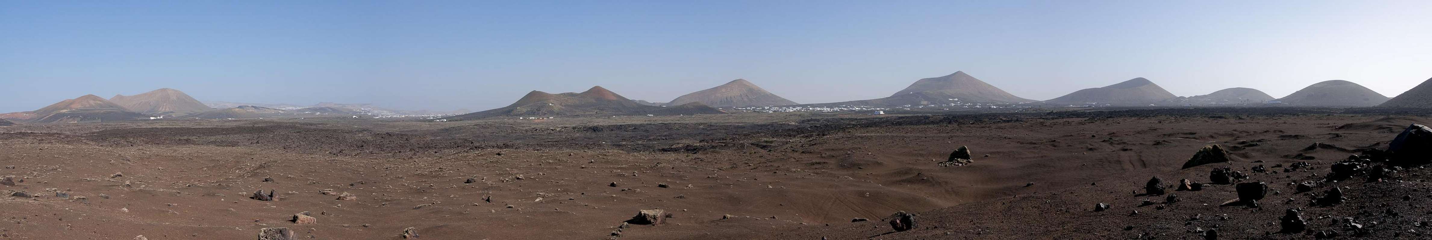
 Montañas del Fuego as seen from Caldera Colorada
Caldera Colorada is one of the few volcanoes of the 1730 - 1736 eruptions which may be climbed. There is a path, which circles the caldera and a short but very steep cinder scramble can take you to the summit. Thanks to its solitary location on the central plain of Lanzarote, Caldera Colorada is a good while not perfect lookout mountain. It is located on the borderline between the Montañas del Fuego in its west and the older Tinajo and San Bartolomé chains in its north-east and south-east.
 |  |  |  |  |
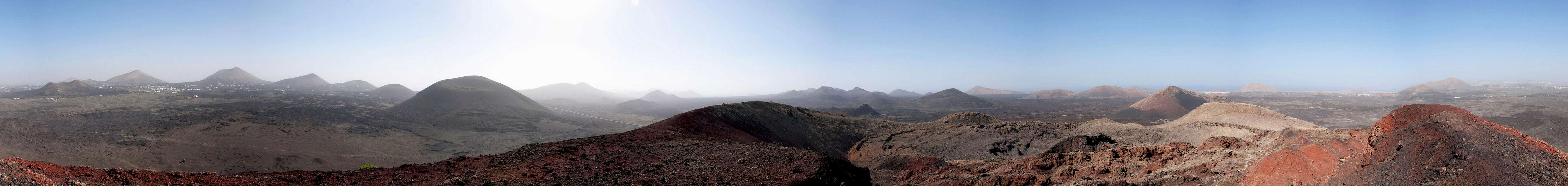
360° Summit Panorama
  |
Getting There
 |
Though there are ferries from the Spanish mainland to the Canary Islands, they take more than 24h for the trip. Therefore most visitors therefore go by plane. Every travel agency in Europe offers flights, hotel rooms, apartments, rental cars etc. so that reaching the Canaries is rather a matter of money than opportunity. During the summer season flight fares can be reasonable but during the Easter and Christmas holidays you have to be prepared for additional fees of 500€ per person.
Lanzarote has its own airport between the capital Arrecife and one of the main tourist centres, Puerto del Carmen. There are public bus lines but – like on all the islands – they don't run too regularly. If you plan to stay on your own, better take a rental car right at the airport.
The best trailhead for Caldera Colorada is south of the village of Mancha Blanca on LZ56. You can also start from Mancha Blanca itself, in which case you can hike a 3h loop, touching Caldera Colorada, Caldera Santa Catalina, Montaña de los Rodeos. The best itinerary (not the shortest but most impressive one) is as follows:
- From Arrecife follow LZ20 through San Bartolomé.
- At the Monumento del Campesino turn onto LZ30 west.
- Drive through Masdache and at the intersection with LZ56 turn northward in direction Tinajo.
- On the highest point of the lava sea, which LZ56 crosses, you pass between Caldera Santa Catalina to the left and Caldera Colorada to the right. Right at the base of Caldera Colorada there is a small parking lot. The Mancha Blanca trailhead is some 3km further northwards, where a paved side road joins LZ56 from the left.
Red Tape
 Caldera Colorada South Face
Caldera Colorada is located at the eastern end of the Parque Natural de los Volcanes. For locals, farming is allowed in the park but all construction or quarrying activities are restricted to some very few areas. It took flora and founa hundreds of years to conquer the volcanic cones so please leave everything in its place.
Accommodation
 |
For holiday homes, hotels or apartments either consult your nearest travel office, or – search for lodgings on Google. There are several sites on the web, dedicated to rent privately owned houses or apartments. Prices are generally a bit less expensive than for tour operators but you don't have as much security.
Weather Conditions
As stated in the overview section, Lanzarote, is usually swept by fierce north-western trade winds. Though they deposit their humidity on almost all of the other Canary Islands, Lanzarote is simply too low to form a decent obstacle. Therefore the climate is very arid.For some time of the year, eastern winds prevail, which almost always carry clouds of Sahara dust with them. Usually this means reduced visibility but in some occasions "Calima" occurs. Fierce storms take up the dust from the Sahara and sweep it across the islands. In these times visibility is nil and sometimes even the planes are grounded.
Maps & Books
Maps
Regular Maps
- Lanzarote
Kompass Map WK241
Kompass Verlag
1:50000
ISBN 3-85491-175-0
Digital Maps
Kompass is the only company known to me which offers GPS digital Maps. In addition for those of you with Garmin GPS receivers there is a map source map set of all Canary islands out there.
- Lanzarote
Kompass GPS4241
Kompass Verlag
ISBN 3-85491-223-4
- Islas Canarias
Map Source custom map
By Manfred Pepper
downloadable zip-file
Books
My recommendation is a guidebook by Rother Verlag, available in German. The book is an excellent hiking guide covering all the interesting areas of the island. Since it comes with small maps for each excursion it might even be used without a map to support them.
- Lanzarote
Rolf Goetz
Rother Verlag
ISBN 3-7633-4302-4