
-
 7828 Hits
-
 77.48% Score
-
 8 Votes
|
|
Mountain/Rock |
|---|---|
|
|
29.00618°N / 13.68866°W |
|
|
Hiking, Scrambling |
|
|
Spring, Summer, Fall, Winter |
|
|
1329 ft / 405 m |
|
|
Overview
 Caldera Santa Catalina as seen from the west Caldera Santa Catalina as seen from the west |
When in September 1730 the first volcanoes started spitting fire in the Timanfaya Region of Lanzarote in what turned into one of the longest living volcanic eruption the village of Santa Catalina in the north-west of the island was one of the first ones to vanish. Don Andres Lorenzo Curbelo, the parish priest of nearby Yaiza, wrote in his diary: "[...] But on Sept 7th a huge rock rose out of the earth with an ominous rumble, forcing the lava to flow west and north-westward. There it destroyed Maretas and Santa Catalina [...] But on October 18th three new craters opened up directly above the burned Santa Catilina, spilling huge clouds of fumes, which covering the whole island with sands and ashes.".
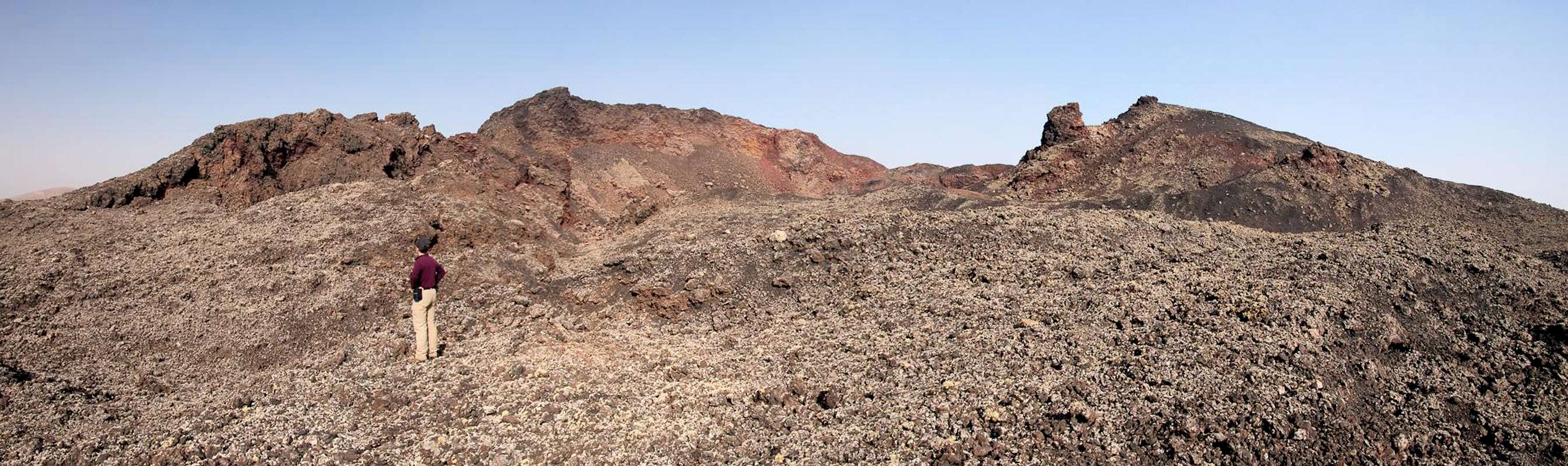
One of these three craters is Caldera Santa Catalina, named after the village it buried and nowadays located not far from the centre of the island (the Timanfaya eruptions moved the Lanzarote coastline further northwards). The crater is one of the wildest one on the island, mostly because only little of its caldera is covered by volcanic ashes. Instead high walls of lava have piled up, seemingly affording vies into the innards of the earth. Crevices have broken up the ground at the western base and inside the crater. Its lava is extremely brittle and often breaks underneath your step so that climbing to the rocky summit volcano is absolutely impossible. The southern summit, however can be climbed though even here danger lurks at every step.
  |
Caldera Santa Catalina is located directly on LZ56, a road which connects the villages Mancha Blanca and Masdache, both of which have only barely been touched by the eruptions, and which runs through the volcanic scenery of the Parque Natural de los Volcanes. Together with its direct neighbour Caldera Colorada it forms a saddle through which the road leads and which serves as a trailhead for both volcanoes. In the past it also served for a different kind of activity: quarrying for Lapilli, the volcanic ashes, which locals use to cover their fields (and which hold back humidity). While at Caldera Colorada there was a quarry, digging directly into the heart of the volcano from its northern side, at Caldera Santa Catalina the Lapilli were spread across the plain to the south of the crater. Here intense quarrying took place so that the whole area is criss-crossed by road tracks. Fortunately the volcano protected itself with walls of lava.
The dirt tracks amount to a big danger in the area: orientation can become difficult. There is a famous (hiking) loop trail from Mancha Blanca, which touches Montaña Ortiz, Caldera Colorada, Caldera Santa Catalina and Montaña de los Rodeos. It leads through the quarrying site south of Caldera Santa Catalina, where it is easy to get lost. Suddenly you find yourself deep inside the huge lava field, which separates Caldera Santa Catalina from Montaña de los Rodeos. If you don't find a track with cairns to follow, turn back! The lava breaks up underneath each step and you can suddenly find yourself several metres beneath the place you stood seconds before. Rescue is possible only on foot so that potential rescuers run the same danger as you.
Getting There
 |
Though there are ferries from the Spanish mainland to the Canary Islands, they take more than 24h for the trip. Therefore most visitors therefore go by plane. Every travel agency in Europe offers flights, hotel rooms, apartments, rental cars etc. so that reaching the Canaries is rather a matter of money than opportunity. During the summer season flight fares can be reasonable but during the Easter and Christmas holidays you have to be prepared for additional fees of 500€ per person.
Lanzarote has its own airport between the capital Arrecife and one of the main tourist centres, Puerto del Carmen. There are public bus lines but – like on all the islands – they don't run too regularly. If you plan to stay on your own, better take a rental car right at the airport.
The best trailhead for Caldera Santa Catalina is south of the village of Mancha Blanca on LZ56. You can also start from Mancha Blanca itself, in which case you can hike a 3h loop, touching Caldera Colorada, Caldera Santa Catalina, Montaña de los Rodeos. The best itinerary (not the shortest but most impressive one) to reach Mancha Blanca is as follows:
- From Arrecife follow LZ20 through San Bartolomé.
- At the Monumento del Campesino turn onto LZ30 west.
- Drive through Masdache and at the intersection with LZ56 turn northward in direction Tinajo.
- On the highest point of the lava sea, which LZ56 crosses, you pass between Caldera Santa Catalina to the left and Caldera Colorada to the right. Right at the base of Caldera Colorada there is a small parking lot. The Mancha Blanca trailhead is some 3km further northwards, where a paved side road joins LZ56 from the left.
Red Tape
 Caldera Santa Catalina as seen from the west
Caldera Santa Catalina is located at the eastern end of the Parque Natural de los Volcanes. For locals, farming is allowed in the park but all construction or quarrying activities are restricted to some very few areas (see overview section). It took flora and fauna hundreds of years to conquer the volcanic cones so please leave everything in its place.
Accommodation
 Caldera Santa Catalina as seen from Caldera Colorada
For holiday homes, hotels or apartments either consult your nearest travel office, or – search for lodgings on Google. There are several sites on the web, dedicated to rent privately owned houses or apartments. Prices are generally a bit less expensive than for tour operators but you don't have as much security.
Weather Conditions
As stated in the overview section, Lanzarote, is usually swept by fierce north-western trade winds. Though they deposit their humidity on almost all of the other Canary Islands, Lanzarote is simply too low to form a decent obstacle. Therefore the climate is very arid.
For some time of the year, eastern winds prevail, which almost always carry clouds of Sahara dust with them. Usually this means reduced visibility but in some occasions "Calima" occurs. Fierce storms take up the dust from the Sahara and sweep it across the islands. In these times visibility is nil and sometimes even the planes are grounded.
Maps & Books
Maps
Regular Maps
- Lanzarote
Kompass Map WK241
Kompass Verlag
1:50000
ISBN 3-85491-175-0
Digital Maps
Kompass is the only company known to me which offers GPS digital Maps. In addition for those of you with Garmin GPS receivers there is a map source map set of all Canary islands out there.
- Lanzarote
Kompass GPS4241
Kompass Verlag
ISBN 3-85491-223-4
- Islas Canarias
Map Source custom map
By Manfred Pepper
downloadable zip-file
Books
My recommendation is a guidebook by Rother Verlag, available in German. The book is an excellent hiking guide covering all the interesting areas of the island. Since it comes with small maps for each excursion it might even be used without a map to support them.
- Lanzarote
Rolf Goetz
Rother Verlag
ISBN 3-7633-4302-4