
-
 4968 Hits
-
 79.04% Score
-
 10 Votes
|
|
Mountain/Rock |
|---|---|
|
|
29.00437°N / 13.70682°W |
|
|
Download GPX » View Route on Map |
|
|
Hiking |
|
|
Spring, Summer, Fall, Winter |
|
|
1339 ft / 408 m |
|
|
Overview
 The crater of Caldera de la Rilla The crater of Caldera de la Rilla |
First of all I have to apologize to post another of these very small mountains of Lanzarote, a volcano called Caldera de la Rilla. However, being part of the Montañas del Fuego, the volcanoes which were created on Lanzarote about 300 years ago during eruptions which lasted three years, it can tell us quite a lot about the Canaries recent volcanism. Moreover, being located out of the way of most of Lanzarote's sight only few people get to see the crater and it seems obvious from what you see around the islands that access to the mountain will be restricted of even forbidden completely. Thus I take the chance to present the wonderful crater of Caldera de la Rilla.
 |  |  |
It is located near the Señalo - Partido Complex where the eruptions, which created the mountains of fire were fiercest. Caldera de la Rilla lies on the east slopes of Montaña del Señalo, which like its northern neighbour, Pico Partido, created a vast jumble of chaotic llava flows, sometimes with very large, sharp-edged boulders. The area is impossible to penetrate so that our caldera is protected from access on that side. To the north-east lies the long-stretched back of Montaña de los Rodeos, a much older volcano, an island in the sea of lava around.
 Caldera de la Rilla, Montaña de Señalo, Pico Partido and a nameless cinder cone
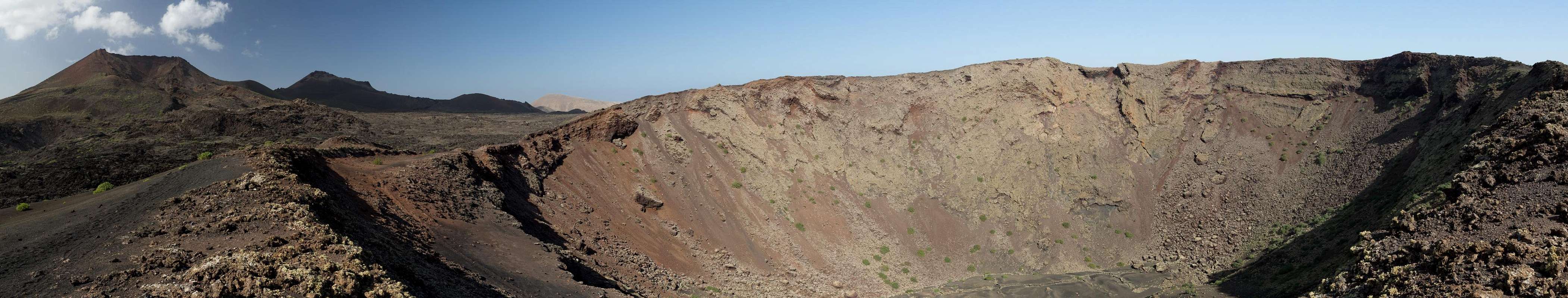
Caldera de la Rilla erupted late during the large Timanfaya outbreaks. Much of the Señalo - Partido activity must have already have subsided as the ashes thrown out of the crater cover a vast area, burying the chaotig blocks underneath. Today it looks like a sea of tranquility among the chaos which rules around. Caldera de la Rilla''s eruption created a perfectly shaped crater, an oval 400m long (east-west) and 300m broad (north-south). It is almost purely made up from cinder with a few rocky blocks at its eastern end. During the eruption a crater lake developed, which nowadays can be witnessed by a giant slab in the centre of the caldera.
 |  |  |
While both routes to Caldera de la Rilla reach it from the east, the actual mouth of the crater is in its west. Two paths circle the caldera, one on the outside where the cinder meets the Señalo lava, the other on the very rim, offering great views inside the crater. The latter is bound to be closed to protect the cinder slopes, as happened at Montaña de los Cuervos, a similar crate nearby (with easy acces from a road, however). Anyway, hiking the rim route usually results in a double circle around Caldera de la Rilla as can be seen from the attached GPS-track.
Crater Panorama
  |
Getting There
 Caldera de la Rilla and Montaña Negra
Though there are ferries from the Spanish mainland to the Canary Islands, they take more than 24h for the trip. Therefore most visitors therefore go by plane. Every travel agency in Europe offers flights, hotel rooms, apartments, rental cars etc. so that reaching the Canaries is rather a matter of money than opportunity. During the summer season flight fares can be reasonable but during the Easter and Christmas holidays you have to be prepared for additional fees of 500€ per person.
Lanzarote has its own airport between the capital Arrecife and one of the main tourist centres, Puerto del Carmen. There are public bus lines but – like on all the islands – they don't run too regularly. If you plan to stay on your own, better take a rental car right at the airport.
There are two possible trailheads, both on LZ-57 between La Geria and Tinguatón. One is in the village Tinguatón itself, the other a small parking lot between Montaña de los Cuervos and Montaña Negra. The latter requires the traverse of a large lava field and is somewhat dangerous if you stray from the path (brittle lava with caves underneath!). You can reach the trailheads as follows:
- From Arrecife follow LZ20 through San Bartolomé.
- At the Monumento del Campesino turn onto LZ30 west.
- Drive through Masdache and at the intersection with LZ56 turn northward in direction Tinajo.
- The first trailhead is on the left hand (western) side at a parking lot north of Montaña de los Cuervos.
- For the second trailhead is also a parking lot on the left hand side, at an intersection just before the village Tinguatón
Routes
 Caldera de la Rilla (left)
Tinguatón Route
From the parking lot follow the dirt road which leads towards the south-west. After a while it turns to the south, now heading directly towards Montaña de los Rodeos. You can pass the mountain on either side as both roads recombine on the broad south ridge of the mountain. However, the shortest route is along the western side, leading into a small cinder valley at the southern base of Caldera de la Rilla. Turn right and follow a narrow path around the crater towards its western end, where the rim circle route starts.
Los Cuervos Route
Follow LZ-56 northward for around 700m. Turn left onto a dirt road which heads westwards. After you passed Caldera Santa Catalina the road turns north but loses itself in a quarry-like maze. After about 100m turn left (west) onto a broad path which soon turns to the north. It passes an elevation (ambiguous here), decends towards the lava plain underneath. You can see the dirt road around Montaña de los Rodeos from here, which the path turns to. It reaches the road in its very end. Turn northward for a few steps until you reach a path which heads up (south-west) towards the broad south ridge of Montaña de los Rodeos. Follow a well worn path across the cinder slopes which leads to the southern side of Caldera de la Rilla. Follow the circle path towards the crater mouth in the west.
Red Tape
 The crater of Caldera de la Rilla
As mentioned in the overview section, access to cinder cones on the Canaries is being restricted. Currently Caldera de la Rilla still can be hiked but it is obvious that signs will be put up soon. The crater is located in the Parque Natural los Volcanes, where - unless you leave trails - you are allowed to hike.
Also, there are tour operators who will guide you to the mountain. However, they won't lead you across the rim path.
Accommodation
For holiday homes, hotels or apartments either consult your nearest travel office, or – search for lodgings on Google. There are several sites on the web, dedicated to rent privately owned houses or apartments. Prices are generally a bit less expensive than for tour operators but you don't have as much security.Weather Conditions
Lanzarote is usually swept by fierce north-western trade winds. Though they deposit their humidity on almost all of the other Canary Islands, Lanzarote is simply too low to form a decent obstacle. Therefore the climate is very arid.
For some time of the year, eastern winds prevail, which almost always carry clouds of Sahara dust with them. Usually this means reduced visibility but in some occasions "Calima" occurs. Fierce storms take up the dust from the Sahara and sweep it across the islands. In these times visibility is nil and sometimes even the planes are grounded.
Maps & Books
Maps
Regular Maps
- Lanzarote
Kompass Map WK241
Kompass Verlag
1:50000
ISBN 3-85491-175-0
Digital Maps
Kompass is the only company known to me which offers GPS digital Maps. In addition for those of you with Garmin GPS receivers there is a map source map set of all Canary islands out there.
- Lanzarote
Kompass GPS4241
Kompass Verlag
ISBN 3-85491-223-4
Inselkarte (Island Map)
Downlaoadable at www.wanderreitkarte.de
Books
My recommendation is a guidebook by Rother Verlag, available in German. The book is an excellent hiking guide covering all the interesting areas of the island. Since it comes with small maps for each excursion it might even be used without a map to support them.
- Lanzarote
Rolf Goetz
Rother Verlag
ISBN 978-3-7633-4302-7