
-
 5489 Hits
-
 70.83% Score
-
 1 Votes
|
|
Mountain/Rock |
|---|---|
|
|
37.97206°N / 22.20073°E |
|
|
Axaia |
|
|
Hiking, Mountaineering, Scrambling, Skiing |
|
|
Spring, Summer, Fall, Winter |
|
|
7726 ft / 2355 m |
|
|
Overview
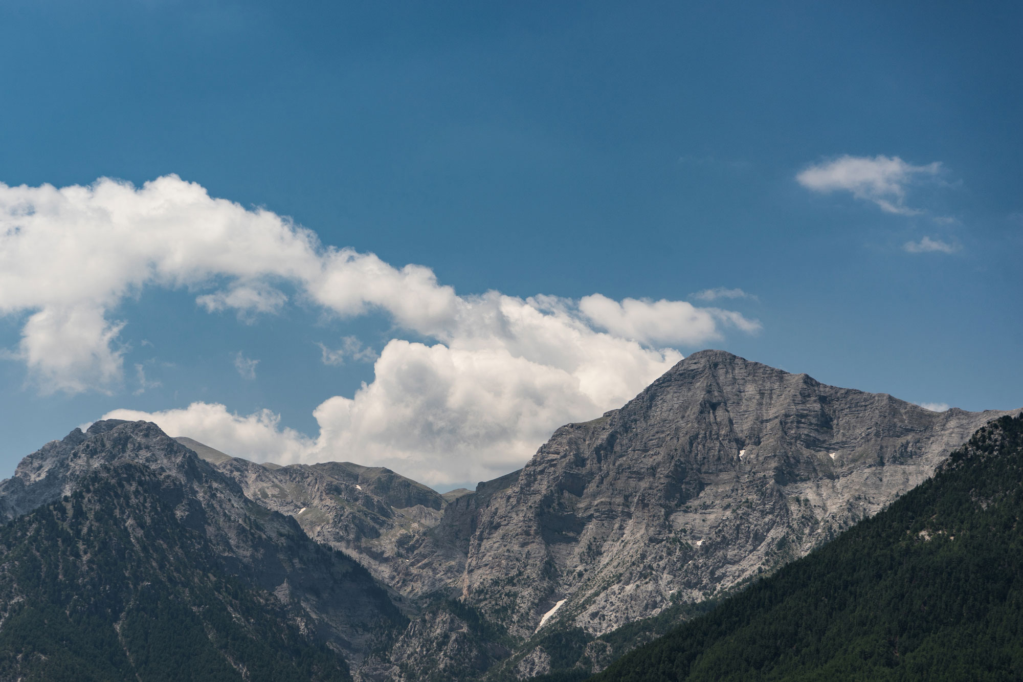
Mt Chelmos (“Χελμός”) or Mt Aroania (“Αροάνια Όρη”) is the Peloponnese's 3rd highest mountain with Psili Korifi (2,355m) [“Ψηλή Κορυφή”] following Taygetos (2,407m) and Killini (2,374m). The massif is well known and popular with a total area of 100 sq. km, it is home to a large ski resort and multiple summits above 2,000m. The massif is also home to three significant gorges, one of them being the famed Styx Gorge (“Στυγα”) to the SE. Further, it is also home to the Arisraechus (“Αρίσταρχος”) space telescope built at an elevation of 2,338m on the shoulder of Neraidoraxi (2,341m), just next to the top of the ski lifts; this is because the mountain is located in one of the least light poluted areas in Southern Europe.
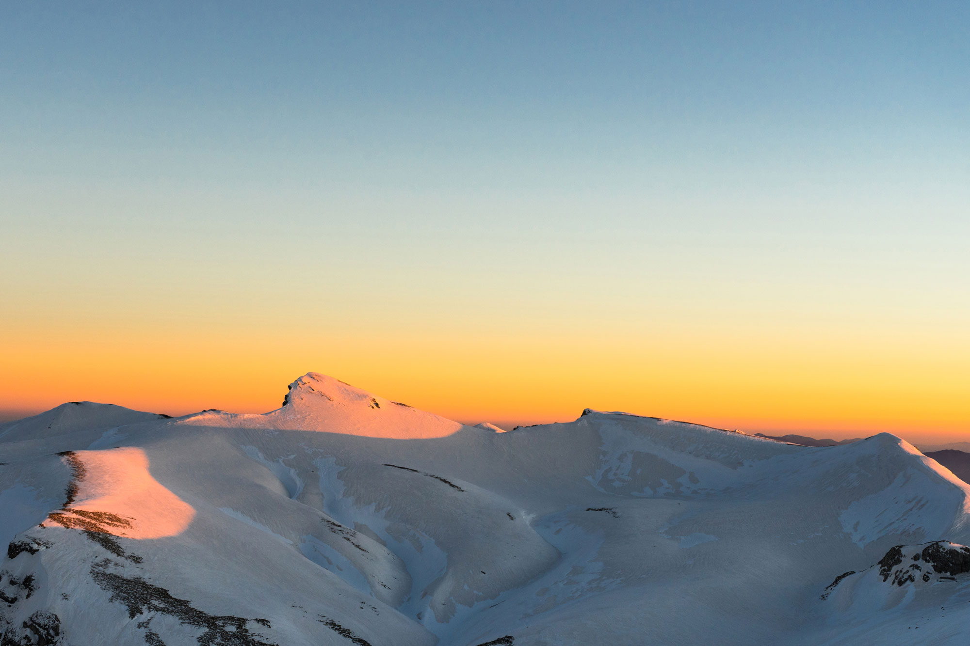
The high peaks of Chelmos
The mountain offers excellent views of the Giona and Vardousia mountains to the North as well as most of the Peloponnese mountains to the South on clear days. In peculiar fashion, the mountain has a high tree line at around 1,900m – 2,000m under the peak of Avgo (2,138m) [“Αυγό”], a local favorite for lift accessible tree skiing.
The general area of the mountain has a deep history being linked, with ancient, medieval, and modern events, it is also one of the most well-protected and developed areas of natural beauty in Greece. It is home to five Natura 2000 protected areas all under the UNESCO Geopark designation - covering the wider region. The mountain and its general area showcase both interesting nature such as lakes, caves, rock formations, etc. but also cultural heritage such as ancient sites and vibrant villages.
History & Area Guide
|
|
|
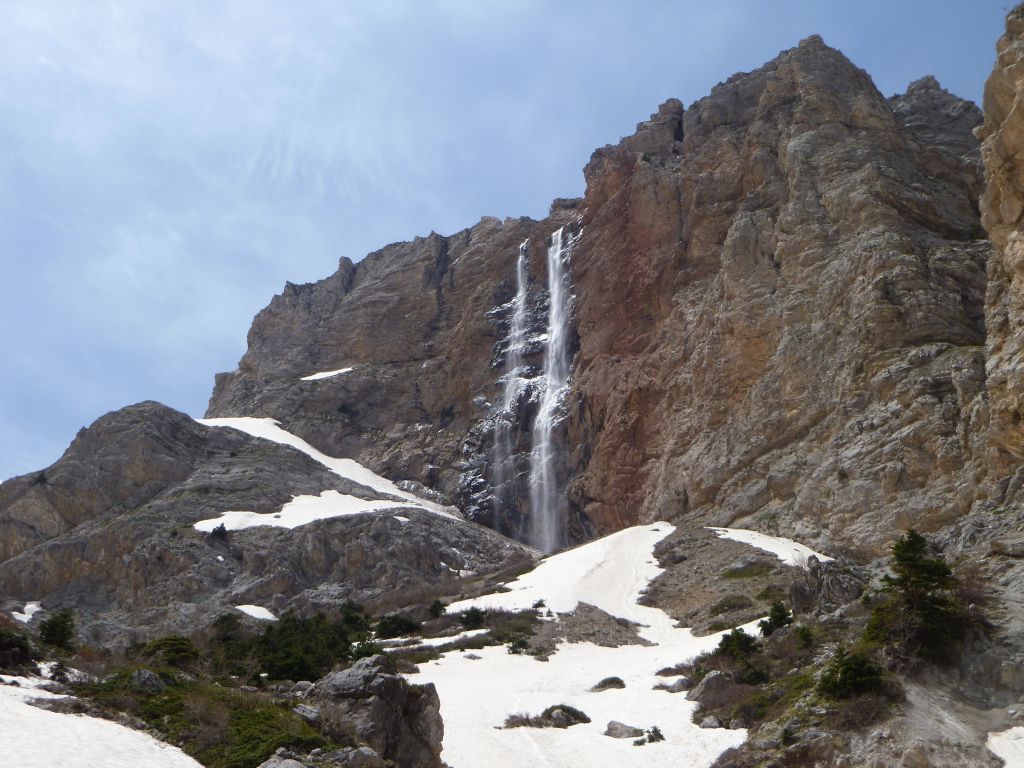
The mountain of Chelmos is mainly related to ancient mythology, and thus, being very early recorded in (oral) history, through the "Waters of Styx" ("Υδατα Στυγος") the springs of the river Krathis ("Κραθη") at 2,100m elevation on the East of the massif. It is said that Styx ("Στυγα") was an Oceanis (a pre-goddess of water of sorts) whose palace waters ran through to the earthly spring on the mountain and were the gates to the underworld. At the spring all Greek gods including Helios ("Ηλιος") would make their oaths, as well as being banished there when they were being punished. Additionally, it is related to the myth of Illiad hero Achilles ("Αχιλεας") who was said to have been baptized in the waters of Styx which gave him his immortality, famously being held up by his heel, causing his storied weekness (achiles heel).
In the medieval period the Castle of Kalavryta or Castle of Oria, situated above the village of the same name was built in around 1208 by Othon de Turnay or de Durnay who was a barron of the "Principality of Achaia" which was acquired through crusader conquest from the Byzantines. Following the battle Pellagonia in 1259 the Byzantines would re-occupy the castle, although it was very far from their other centers of power. It would continue under Byzantine knight rule as political turmoil continued and would come under the Venetians in 1686. The Ottomans would recapture it in 1715 for just over 100 years as the 1821 Greek Revolution, which in folk legend began at the village of Kalavryta, saw it fall into Greek hands. It became disused in 1829 as it was in "core" territory and had no strategic utility.
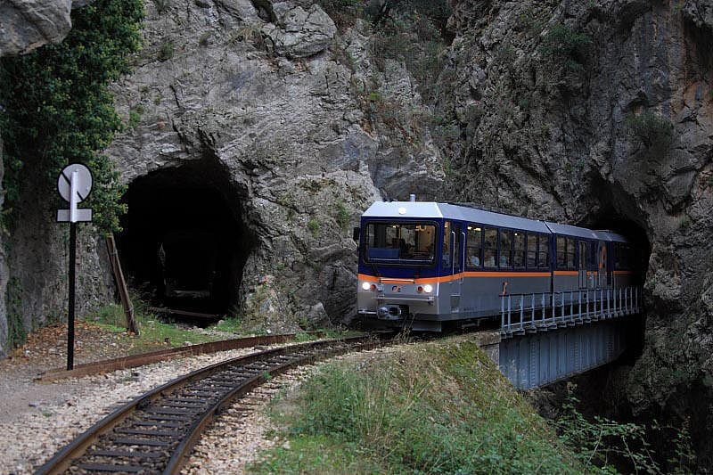
The "Odontotos" railway connecting Diakopto with Kalavryta was built in 1896 following the Vouraikos gorge up towards the mountain. At the time this was considered a feat of engineering given the steep terrain as well as the overall location of the track within the narrow and deep canyon. The total length of the line is 22km.
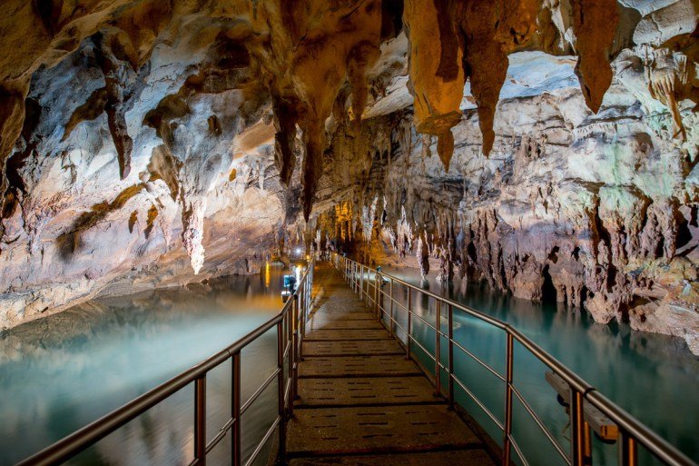
The "Cave Lakes" ("Σπιλαιο Λιμνων") while known since ancient times was first conclusively explored in 1964 by inhabitants of the nearby village of Kastria. The cave is located on the South West side of the mountain and is about 2km long, contains 13 lakes, all bunched together in a section of about 300m, while at its deepest it is nearly 400m below the surface of the peak above. The entrance of the cave is at an elevation of 800m above sea level and its latest part was opened to the public in 2001. The cave is home to one of the most important winter bat colonies in Europe, with a population exceeding 18,000 during the season.
Getting There
Access to the mountain is generally performed from the North and the area of Kalavryta. The valley of Zarouchla (“Ζαρουχλα”) to the East is also a point of access via the village of Solos (“Σολος”) and has road access to the ski center – when cleared – as well as a dedicated trail going up the “Waters of Styx”. Additionally, one can access the North-South trails – which are much harder – from the village of Planitero (“Πλανητερο”).
Via Car
If you are driving into the area you can go to a number of villages, either in the area of Vouraikos – below or at Kalavryta –, Zarouchla or Planitero. If you are aiming to hike from the North (standard route) or go skiing you must get to the ski center parking lot, about 20 minutes from Kalavryta town center. The following are directions to common locations:
If approaching from the North in the summer and early fall, it is possible to drive all the way to the Arisraechus telescope using the logging road from the ski center base.
Via Public Transport
It is possible to get to the city of Kalavryta from Athens using public transport! Starting from the Airport take the subway (blue line) to the Port of Piraeus. From there continue on the suburban train towards Kiato (“Κιατο”). Once at Kiato get on the regional bus (so called KTEL) from Kiato to Patras and get off at the town of Diakopto. Up to this point the trip is over 4 hours. From Diakpto take the Odontotos train to Kalavryta, this should take about 1 hour. In total you should be there in about 5-6 hours. About twice as long as via a car.
Via Ski Bus
During the winter months there is regular daily and weekend bus service to the Kalavryta ski center and by extension the town of Kalavryta. The buses usually pick up passengers on the main roadways of Athens between 4 and 5am, arriving at the resort at around 9.30 to 10am.
For more information check out the Kalavryta Ski Center Ski Bus info page.
Route(s)
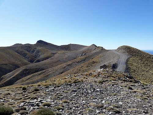
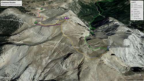
There are two main routes to tackle an accent to Psili Korifi (2,355m), one starting from the ski resort parking lot and one from the village of Solos which hikes through the Styga gorge and above the "Waters of Styx", this is considered the "long" route. There are additional trails with access from the South, as well as a famed mountaineering route using a ridge on the South East. The Styx route is visible in Green while the Direct routes are in orange and red.
Ski Center Direct (North to South)
- Distance:
- Duration:
- Elevation Gain: 605m
- Difficulty: Medium
- Water: None
Overview
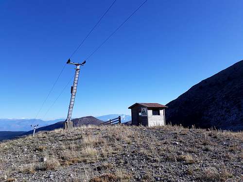
This is the primary route to access the summit of Psili Korifi (2,355m) ["Ψηλη Κορυφη"] - meaning tall summit - from the ski resort and parking lot on the North base of the mountain. It begins at 1,750m thus has a total gain of 605m, most between "Vatheia Lakka" at 1,900m and the Arisraechus telescope at 2,338m. The final section between the telecope and summit is a ridge walk with little elevation gain. There is variation between the parking lot and the emergency hut at about 2,000m.
Through the Slopes
Head from the base of the anchor lift to the East of the parking lot up towards "Vatheia Lakka" by following the slopes. From there one can follow the slopes on the left or right to head towards the hut. The trail moves towards the right, following the slopes will increase the overall steepness of the route.
Hut to Telescope
From the Emergency Hut the route follows the ridge to across from the telescope. It is possible to hike up the slope (steepest here) to get to the telescope before moving on towards the summit.
Telescope to Summit
From the Telescope move south towards the pass while following along the road, where the dirt road bends at the pass, continue on the ridge and follow it across to the summit which sits at the Eastmost end of the ridge. This last section is less than 1 hour.
List of Highest Peaks
 |
 |
 |
| Psili Korifi | Profitis Ilias | Koukougeras |
| 2,355m | 2,282m | 2,280m |
| 37.9720N - 22.2008E | 37.9618N - 22.1985E | 37.9618N - 22.1985E |
 |
 |
 |
| Neraidoraxh | Gardiki | Avgo |
| 2,241m | 2,182m | 2,138m |
| 37.9903N - 22.2024E | 37.9619N - 22.2298E | 38.0025N - 22.1833E |
When to Climb
Due to the long distances of most of the routes on the mountain it is better to avoid warm months and general warm periods.
The best conditions are to be found between September and May.
Try avoiding the mountain during high avalanche risk days as well as cold storms, since it is exposed to winds and storms. There are usually lingering snow patches at high elevations all the way through May. In late spring and early summer the seasonal lake of Mavrolimni ("Black Lake") above the "Waters of Styx" can be seen.
Weather Conditions & Forecast
Weather and Condition Report from the Ski Center Including Avalanche Report!
View detailed snow forecast for Kalavryta Ski Resort at:
snow-forecast.com
Huts & Camping
As is usual wild camping is permited in Greece and no permits are required. In Chelmos it is common for people to camp on the alpine sections of the range, in "Vatheia Lakka" above the resort, below the telescope, around the disused refuge, and finally below the summit.The Chelmos mountain refuge V. Leontopoulos, located in the Avgo shoulder, is not completed and has remained locked. Its general structural integrity is questionable and thus, it is not used.
It may be possible to use some of the ski center facilities - such as the top lift hut - to stay on the mountain overnight although this must be organized with the resort.
Chelmos-Vouraikos UNESCO Geopark
The UNSECO Geopark links 5 Natural 2000 protected areas under a single umbrella, this initiative was started in 2002 and began operation in 2008, in 2015 it joined the UNESCO global Geopark network. In the territory there are rivers, lakes and the entire range of the Chelmos Mountains, as well as the Vouraikos Gorge. With an area of 654 km², 62 municipalities and for a total population of 27,125. The park is managed directly by the Greek Ministry of the Environment and Energy.
Learn more about the Geological aspects of the park via the Chelmos-Vouraikos Geopark Website.

|

|

|
Geology
The mountain of Chelmos is of high geological interest due to it being mainly composed of Limestone which has led to several complex water features being created such as the "Cave Lakes", the sinkhole "Eye of Ladon", and the alpine lake of "Tsivlos". Within the park there is a plethora of different rock types as well as, 10 geological periods and 3 geotectonic zones.
Flora
The geopark contains more than 1,100 unique species of flora many of which is endemic to Greece in general, and to the Peloponnese specifically, additionally, many are under conservation regimes or classified under the IUCN Red Data Book. In total thirty endemic species of the Peloponnese, more than one hundred Greek endemics and five local endemics of Chelmos can be found here. There is also a unique local plant with called "Globularia stygia", whose name was given after the waters of Styx; it grows on rocks and ledges between 1,150m and 2,300m on the mountain.
Fauna
The mountain is also home to protected fauna, in total 76 species of invertebrates, 4 species of fish, including 2 endemics, 9 species of amphibians, 23 species of reptiles, among them there are 9 endemic species, 18 species of mammals. Besides these, 149 bird species find permanent or temporary refuge in the area. Most notable are the endangered and rare alpine butterflies which live at high elevations on the mountain. The geological formations of the area including gorges, waterways, caves and, rocks play a key role in providing habitats for all these animals.
You can read more about the rare species of butterfly that live on the mountain in Alice Hunter's "Mount Chelmos and its endemic butterflies" from 2019.
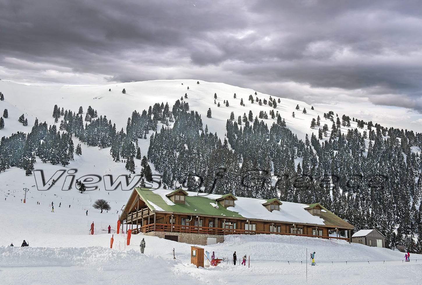
The Kalavryta Ski Center
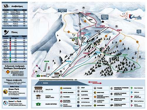
The Kalavryta Ski Center is located on the Northwest side of the mountain, above the village of Kalavryta (“Καλάβρυτα”), it has 7 ski lifts and 12km of slopes as well as the only large terrain park in Greece. Its base elevation is 1,750m and the highest point is at 2,340m for a total elevation delta of 590m. In total it has 2 chalets serving food and drinks, at the base and mid stations. The skiing is mainly in the North, and Northeast/West aspects as the mountain creates a bowl. There is quality tree skiing below Avgo (2,138m) and alpine faces below Neraidoraxi (2,341m), facing West.
In the 2023 season adult day ticket prices were €30 in the high and €20 in the low season.
In 2022 the Freeride World Qualified (FWQ) 2* event in Greece took place at the resort, the face “Charos” (“Χάρος”) was used.
- Athlete Fabian Lentsch shot a powder segment here for “Ya Mas – Snowmads in Greece” in 2017.
- Austrian rider Tom Steiner shot a short film about the resort and mountain in 2022 during the FWQ event week, “Hellas Powder Paradise”.
- It was featured in the 2016 full length film “Frozen Ambrosia” by Constantine Papanikolaou.
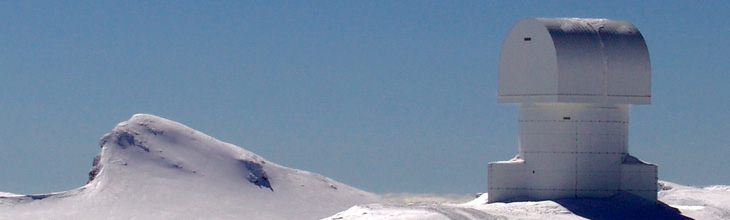
Chelmos Observatory
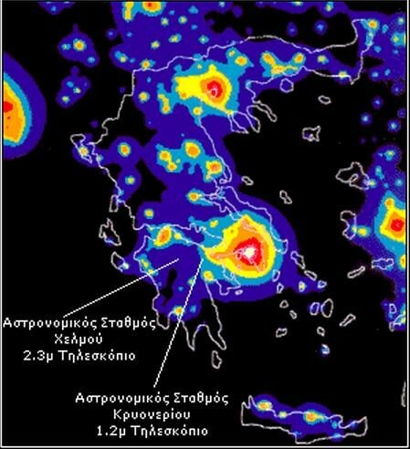
The Arisraechus Telescope is an infra-red Ritchey-Chretien telescope of 2.3m diameter built by Carl Zeiss in 2007 located at 2,438m on Neraidoraxi of Chelmos mountain, just next to the Styx double ski-lift top-station, it is the largest of its type in Southeastern Europe. It is operated by the Observatory of Athens and is part of the OPTICON European network of IR telescopes. Its location in a low light pollution area and at a high elevation making it extremely useful for scientific research. Its name is derived from the Greek philosopher, mathematician, and astronomer Arisraechus of Samos (310-230 BC) who was the first to suggest a heliocentric model of the solar-system.
In 2013 the researchers Panos Boumis and John Meaburn would utilize this telescope alongside the support observatory in Kryoneri to study the age of the KjPn8 bipolar planetary nebula which was discovered in 1971. Their study was successful and they were able to calculate the age of the nebula "waves" at 3,200, 7,200, and 50,000 years ago respectively. Supposedly this was a task which the Hubble Space Telescope was unsuccessful at in 2000.
External Links
The Greek Mountain Path Data Base (GPX Files)