
|
|
Mountain/Rock |
|---|---|
|
|
46.73370°N / 11.04020°E |
|
|
Mountaineering, Skiing |
|
|
Spring, Summer, Fall, Winter |
|
|
10591 ft / 3228 m |
|
|
Overview
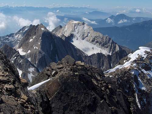
View from Hochwilde, with Lodner in the center and Hohe Weiße on the left
To be true, if you only look at the mountain from the surrounding valleys below, you won't be able to see this. But climb one of the higher mountains close by and you'll see. The best viewpoints are from the top of the Hohe Weiße, 50 m higher and a mere kilometer to the north, and from the Hochwilde, a bit further to the NNW and a few hundred meters higher. If you ever stand on top of either of these peaks in decent weather and look south, you'll instantly recognize the remarkable form of the Lodner.
View from the N, from Hohe Weiße. Note that, unlike the WNW ridge, the N ridge does not go all the way up to the sumit plateau.
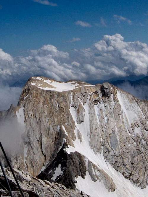
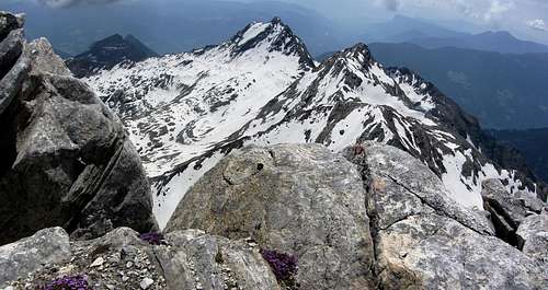
Apart from its shape, a second distinghuishing feature of the Lodner is that, especially from the north, it appears to be unusually light. The giant that beheaded it must have been rich, because a substantial part of the mountain is in fact made up of marble. It's a yellowish light grey. But unlike its shape, this property is less unique. Several mountains nearby show similarly light rocks, albeit not quite as abundant.
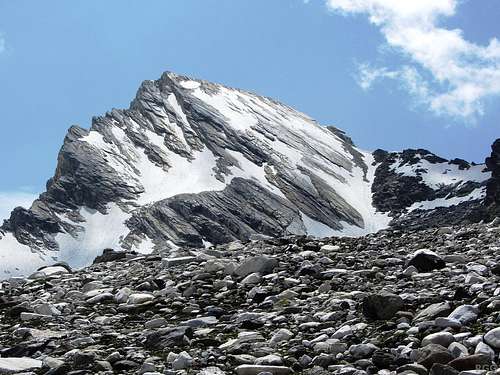
Lodner from the NNE, just below the former Andelsferner
Glaciers and Valleys
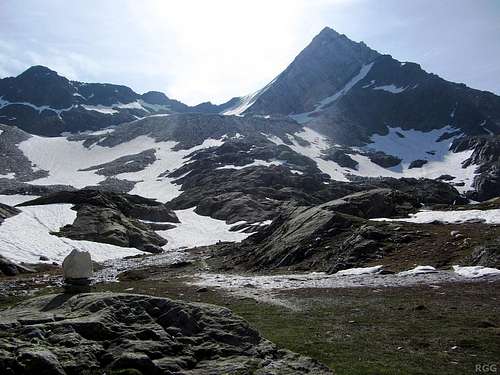
Until recently, several small glaciers lined the slopes of the Lodner. Northwest of the mountain, the Lodnerferner (ferner = glacier) filled a big bowl. However, by 2013, the glacier was reduced to a small ice field. A long time ago, this glacier went all the way to the summit and in 1872 it was the route of the first recorded ascent, by V. Hecht and J. Pinggera. These days the permanent ice doesn't reach higher than about 3100m, up to a shoulder on the N ridge.A smaller glacier, the Andelsferner, used to be on the slopes to the northeast. When I crossed it in 2013, the area still had an unusual amount of old spring snow, but I found no traces of ice under it. I can't rule out that there is still some left, but I don't think so.
At the time of writing, the Google satellite image for the area is poor, but, fortunately, Bing's aerial map is crystal clear.
It shows some snow and some bare ice in the top left, the location of the Lodnerferner, and only some snow in the top right, where the Andelsferner used to be. There may still be some ice under it, but the area covered with snow is small.
To the west lies the Zieltal valley. At the northern end of this valley is the Johannesschartl (2854m), with a difficult hiking trail across, down to the Pfossental on the other side.It shows some snow and some bare ice in the top left, the location of the Lodnerferner, and only some snow in the top right, where the Andelsferner used to be. There may still be some ice under it, but the area covered with snow is small.
The Zieltal is home of the Zielbach. It starts small, fed by melt water out of the Lodnerferner bowl, but it soon gets bigger. Further south in the valley, still not even 2 km southwest of the Lodner summit, lies the Lodnerhütte (2259m). At that point the Lafaisbach, coming from the southwest, adds its water to the Zielbach. The valley continues south, all the way out of the Texel group and down until it meets civilization in the large east-west running Vinschgau valley.
To the east is the Andelsboden. In summer, small herds of farm animals can be seen grazing there. There are some ponds, and a few streams flow down to the north, but they are small enough to simply step over.
A marked trail (nr 40) up the Andelsboden connects the Pfelderer valley further north with the Halsljoch saddle (2808m), which is just over 1.5 km southeast of the Lodner summit. On the south side of the Halsljoch the trail quickly turns west, passing a couple of tiny lakes called the Tablander Lacken and then descending to the Zieltal and the Lodnerhütte.
Ridges and Faces
A jagged ridge to the north connects with the Hohe Weiße. That is, just below the summit plateau it would be more appropriate to talk about a north face instead of a ridge, but soon the ridge starts to take shape and a further north it gets serious. See the photo above, taken from Hohe Weiße.The east ridge starts steep right off the summit plateau, but lower down it eases andt turns towards the northeast. Below 2900 it is real gentle. By now it would be more accurate to call it the edge of a gently sloped plateau than a ridge. That plateau is the home of the former Andelsferner. In stark contrast, the southeast side of the plateau features impressive sheer cliffs.
Another steep ridge drops off the plateau to the south, but then soon turns towards the southeast and gets easier. After several small, unnamed summits, the ridge eventually leads to the Lazinser Rötelspitze (2037m), and just beyond to the Halsljoch.
Finally, from the summit plateau, a fine looking ridge made of marble and granite stretches to the west by northwest. Overall, it is not quite as steep as the other ridges, but there are a few steep sections.
Between the ridges are a couple of faces. Some are steeper than others, but none are easy. In short, no matter from what side you come, all the ridges and faces are too steep to hike up. Even the easiest route to the summit involves a short section with climbing moves up to UIAA grade II.
View down from the summit plateau to the sheer cliffs, deep down below, at the edge of the old Andelsferner plateau
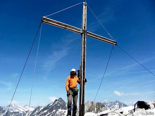
Summit cross
The Summit
A cross marks the true summit, close to the southeast edge of the plateau. By height, the Lodner is not much lower than Roteck (3337m), the highest peak in the group. As a result, the summit views are impressive. Apart from the Texelspitze, which is hidden behind Roteck, most of the other high peaks of the group can be seen, as well as many others further away.| S u m m i t V i e w s | ||
 Lodner summit view to the Spronser Rötelspitze, Tschigat, and the Lazinser Rötelspitze |  Nearby summits in the Texel group, and distant ones in the Ortler group | 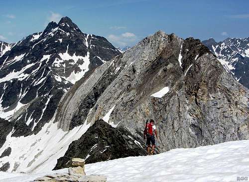 Hohe Weiße and, a bit further back, Hochwilde |
Getting There
The nearest city is Meran / Merano, a pleasant place southeast of the Texel Group. In summer, the area attracts a lot of visitors and for a small city it is well connected.By car
- From the north there are three options:
- Along the provincial road over the Reschenpass via Nauders and then down the Vinschgau valley;
- Via the mountain road over the Timmelsjoch (closed in winter) and then down the Passeiertal;
- Over the Brenner motorway via Sterzing, and then also down the Passeiertal.
- Along the provincial road over the Reschenpass via Nauders and then down the Vinschgau valley;
- From the south, the only way is by the motorway from Bozen / Bolzano.
- From Switzerland, in the west, the Ofenpass and then down the Vinschgau valley is the most logical route
By public transport
Meran has regular train connections with Bozen / Bolzano, which is well connected to the rest of the Italian rail network as well as to Austria and Germany to the north. In addition, a regional train heads up the Vinschgau valley, west of Meran, as far as the small village of Mals.From the north, from Austria, regular buses come over the Reschenpass to Mals. And likewise, from the west, from Swizerland, regular buses come over the Ofenpass to Mals.
Getting Closer
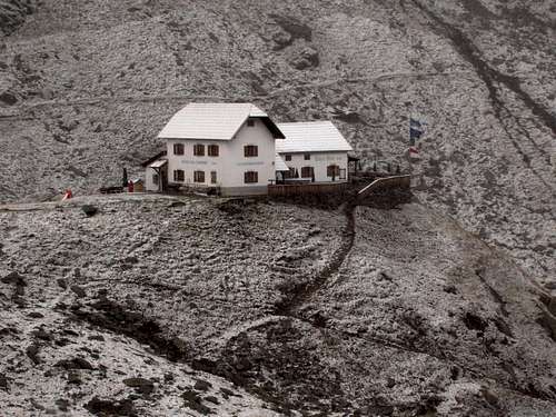
Summertime at the Lodnerhütte, 4 September 2007
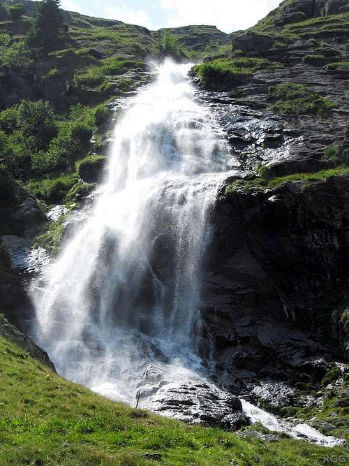
Waterfall in the Zieltal valley
In the northwestern part of the Texel Group lies the Pfossental, itself a side valley of the Schnalstal which in turn connects to the Vinschgau. The road up the Pfossental is only open to the public as far as Vorderkaser (1670m). You can park there. To climb the mountain from there, you would have to start early and be in pretty good shape. The route starts easy, by hiking up the Pfossental to the east. Just before it gets steeper, take a right turn to the Johannesschartl. A difficult hiking trail crosses this small saddle and descends into the Zieltal on the other side. It takes the better part of a day from Vorderkaser to the Lodnerhütte.
The Pfelderer valley, a side valley of the Passeier valley which stretches north from Meran, penetrates deep into the Texel Group from the northeast. To climb the mountain from the northeast, the head of the Pfelderer valley is a good place to start. Alternatively, from Pfelders to the Stettiner Hütte, north of the mountain, takes about 4 hours, and that's also a good alternative for the Lodnerhütte for some of the routes. Finally, the shortest route from Pfelders to the Lodnerhütte crosses the Halsljoch pass (2808m), requiring 5 to 6 hours. If you're in good shape, you could climb another peak along the way, such as the Lazinser Rötelspitze or Tschigat from the Halsljoch.
Routes
There are easy scrambling routes and sometimes even hiking trails to many summits the Texel Group, including most of the 3000-ers. But some of the mountains are reserved for climbers only, and the Lodner is the one of the highest in that group. There are quite a few alpine routes to the top; here is a short overview.| Route | UIAA grade | Key points |
|---|---|---|
| "Lodnerferner" or NW route | II | From the NW over the Lodnerferner, relatively easy up to the shoulder just N of the summit (±3100m). Then steep, including a short climbing section on slippery slabs to the edge of the summit plateau. Crampons are often necessary.See the separate route page for more details. |
| "Andelsferner" or NE route | II or III | Easiest in winter or spring, when the steep couloir below the NE side of the Lodner shoulder is filled with solid snow. First over the former Andelsferner, then up this couloir. It starts easy, but gets steeper higher up, and the last few meters are about 50°. The warden in the Lodnerhütte told me that he had skied down this couloir. From the shoulder the route is the same as the "Lodnerferner" route.When the couloir doesn't have enough solid snow, it is still possible to gain the ridge between Lodner and Hohe Weiße somewhat further north than directly at the saddle, and follow the ridge south from there (UIAA grade II or III). When I was coming up the Lodnerferner, I saw someone on that ridge, and when we met, I asked him about it. It's somewhat harder than the direct route up the couloir, and takes more time, but without snow it is the easiest option from this side. |
| E ridge | III | Exposed, not always solid rock. |
| S ridge | II | Difficult route finding, exposed, not always solid rock. |
| SW face | IV- | Longest route, not always solid rock |
| WNW ridge | III | Mostly grade II, exposed, good quality rock. Some sources call this the W ridge, others the NW ridge. |
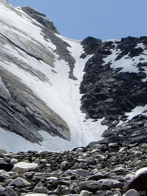
The couloir above the Andelsferner, leading up to the shoulder on the N ridge
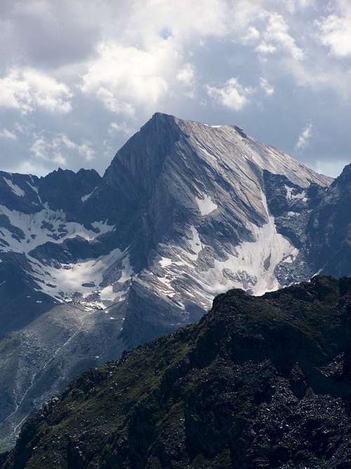
Lodner from the Sefiarspitze, looking directly at the E ridge. On the left is the steep S ridge, on the right is the couloir, but with little snow.
When to Climb
The best period depends on the route. The WNW ridge is best when there isn't to much snow anymore, which normally is from late spring to some time during the fall.The Lodnerferner route is easier and somewhat safer with a layer of solid snow. Without it, the lingering ice of the Lodnerferner, below the Lodner shoulder, means you'll need crampons there. In addition, above the saddle to the edge of the summit, solid snow on the route means good traction and less loose stuff, making it easier and safer than climbing the marble slabs. You may need crampons here too. In short, this makes winter, spring and sometimes early summer the best period.
The Andelsferner route variation via the couloir is only possible with solid snow in it, and when there is no serious avalanche risk. That makes it a winter and spring route. 2013 was exceptional as there was still enough snow by mid July. Without snow, you have to gain the ridge further to the north and then follow it south, which is somewhat harder.
These look like fine conditions.
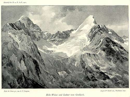
The drawing, by E. T. Compton in 1901, shows Hohe Weiße and Lodner from the Grubjoch, a nearby 2900m high saddle to the NW.
According to the caption, it is true-to-nature - but the steepness is slightly exaggerated
Lodner from high in the Zieltal, at around 2600 m, in 2013
Accommodation

The Texel group from the Rabland train station. Lodner isn't visible from here, because it's hidden behind the rounded peak on the left.
Note: Early 2014, the Stettiner Hütte was struck by an avalanche. It has reopened for day visitors, but until further notice staying overnight is not possible. For information about the latest situation, check the site of the hut.
Meran and the many villages in the valleys all around offer lots of options. On the south side of the Texel Group, the Vinschgau valley has numerous villages with plenty of accommodation options, ranging from simple camp sites to luxury hotels.
One of the last villages in the Pfelderer valley is Pfelders (1628m), in winter a ski village, and consequently it has plenty of hotels. In contrast, the Pfossental valley has no villages, but the last farm, Eishof Pfossental, offers simple accommodation and good food.
Wild camping is not allowed.
Red Tape
The Texel Group is a Natural Park, and is protected as such.Maps and books
- The 1:25000 Tobacco map Parco Naturale Gruppo di Tessa covers the whole national park. It is the most detailed map, but considering its scale, it gives relatively poor information.
- The 1:50000 Freytag&Berndt map WK S8, Passeiertal * Timmelsjoch * Jaufenpass is sufficient, although the 100m contours are rather coarse. It only covers part of the Pfossental, starting a little bit east of Eishof. Not that you really need a map to hike up the Pfossental to begin with.
- Excellent free topographic maps are available at the base station of the Texelbahn cable car. It covers a somewhat smaller area than the other maps, and highlights the the Meraner Höhenweg, but it has all the other trails and many details. The contours are 50 m. With a bit of fantasy, you could say that the Meraner Höhenweg circumnavigates the Lodner ;-). The higher scale and smaller area means it's a small map and it weighs very little. Just one minor point though: The map legend claims that it is scale 1:50000, but it is close to 1:60000.
- A good guidebook, in German, is the Alpenvereinsführer Ötztaler Alpen, Walter Klier, 14th edition, 2006. Bergverlag Rother GmbH, München. ISBN 3-7633-1123-8. However, the details about the Lodnerferner route in this book are outdated: The glacier must have been much bigger when these were valid.
External Links
VinschgauPfelders

On the far left is the Lodner WNW ridge. Scroll to the right, and eventually Hochwilde and Hohe Weiße will pop into view.