
-
 866 Hits
-
 77.48% Score
-
 8 Votes
|
|
Mountain/Rock |
|---|---|
|
|
Hiking, Scrambling |
|
|
Summer, Fall |
|
|
7306 ft / 2227 m |
|
|
Overview

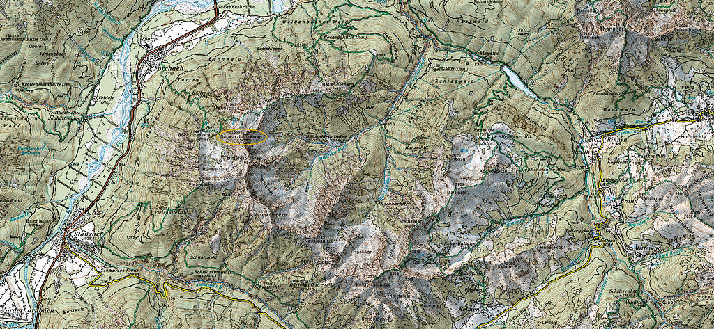
The wellknown and huge Lechtal Alps area end in the east with some lonely, rather unknown and remote ranges. The Liegfeist area is among those. Bordered by the Lechtal valley to the west, Liegfeist ridges build a huge W which is open to the northeast. The southernmost topo point of this W is the highest peak of the subgroup, Knittelkarspitze. The second highest peak is called Schwarzhanskarspitze, located at the northernmost topo point of the W. That´s our peak now.
Schwarzhanskar means black jack cirque – don´t ask me why the locals named the peak this way. Liegfeist, too, is a strange denomination and I have no guess from where it comes.
Schwarzhanskarspitze sends a short ridge to the northwest that drops down to a subsummit, called Mahdspitze, a nice and easy rock peak. To the northeast follow Schartenberg and Hallanderberg, the end of the main W-shaped ridge. Mittergrotzenspitze and Pleisjochspitze are located to the south. Whereas Schwarzhanskarspitze has at least two marked trails winding up to the summit, the southbound Liegfeist summits have none and are off-trail-adventures.


The west slopes of Schwarzhanskarspitze drop down to 1300 m lower Lechtal valley. There is a beautiful and remote cirque area, called Älpele and Hahnspiel, which give access to the summit regions of Schwarzhanskarspitze, Mittergrotzenspitze, Pleisjochspitze and tiny Pleisspitze, a subsummit of the latter. The cirques and valleys to the east are remote, without trails and tracks and end at Rotlech valley, another remote and lonely valley which separates Liegfeist area from Thaneller and Lorea ranges.
I summited Schwarzhanskarspitze two times, on the Hallanderberg route many years ago – in times without internet and digi cams - and on the Forchach route in 2022. I would like to return for the Älpele traverse route one day.
Getting There
- Trailhead for the Hallanderberg route is the village of Weißenbach am Lech, Schwimmbadweg. Look for possibilities to park your car.
- Trailhead for Forchach route or Älpele traverse route is the village of Forchach, hiker parking area Forchach (fee required).
- The complete traverse of Liegfeist area starts at the village of Rinnen and the hiker parking area Rotlech valley
Approach by car:
Weissenbach and Forchach are located alongside road number 198, the Lechtal valley main road.
- Use road number 200 and 198 from Lindau, Bregenz and Dornbirn region to the trailheads.
- Use highway A 7 and road numbers 179 (to Reutte) and 198 from Kempten and Füssen region to the trailheads.
- Use highway A 95 and road number B 2 to Oberau, road number B 23 to Ettal, road numbers St2060 (Germany) and L255 (Austria) to Reutte and proceed on road number 198 to the trailheads.


Public transportation:
Next railroad station is Reutte / Tirol.
- Bus numbers 110 and 120 go from Reutte railroad station to Weißenbach Kirchplatz station or Weißenbach Kreuz station.
- Bus number 110 goes to Forchach Dorf station.
Routes Overview
Hallanderberg route
Trailhead Weißenbach am Lech, Schwimmbadweg


Cross the river Lech on a footbridge. Follow the forest road up to Hochegg hunters cabin and take the trail navigating around the east ridge of Hallanderberg and the south slopes of this subsummit. From the col west of Hallanderberg (Hallanderberg can easily summited from this col) follow the ridge in western direction to Schartenberg subsummit and the col between Schartenberg and Schwarzhanskarspitze. The trail zigzags up the north ridge to the summit cross.
Forchach route

Trailhead Forchach village
Cross Forchach village and leave the village on a forest road to the southeast. Leave this road immediately where a trail branches off to the right. Follow this marked trail steeply up the woods, crossing the forest road several times, to “Beim Ruhebänkle” (a vistapoint) and to the hunters cabin “Hüttenhof”. The trail levels out at the Älpele cabins (also called Hochstanzer Alpe) with the Älpele and Hahnspiel cirques, a beautiful and remote part of the mountain.


Cross Älpele meadows on the trail and ascend the west slopes of Schwarzhanskarspitze. At some point, near level to this subsummit, Mahdspitze can be summited easily as an encore.
The trail reaches the col between Schartenberg and Schwarzhanskarspitze, follow the north ridge to the summit.


Älpele traverse route
Follow the Forchach route to Älpele and beyond. Leave the Forchach route above Älpele, where the trail bends to the left to leave Älpele cirque. Go straight on there into Hühnerspiel cirque and in the direction of Pleisspitze. There are some tracks up to the ridge Pleisspitze – Pleisjochspitze. Follow this ridge from Pleisspitze up to Pleisjochspitze – there is a very steep section involved. From Pleisjochspitze follow mainly the ridge crest unmarked and off-trail with scrambling and some climbing up to grade II to Schwarzhanskarspitze, traversing Mittergrotzenspitze. Wild, remote and impressive landscape.
Descend the Forchach route.


Liegfeist complete traverse
The complete Liegfeist traverse is a two days undertaking with a camping night on or near the ridge where it is convenient. The main problem is to have enough water with you! Forest roads, trails, a via ferrata and, starting from Knittelkarspitze to Schwarzhanskarspitze, lots of scrambling and easy climbing (grade II) is involved in this rather epic adventure.
It is best to do it with public transportation as the starting point and end point are not the same.


Route:
Rinnen – Rotlech valley – Ehenbichler Alm – Abendspitze – Galtjoch – Vordere Steinkarspitze – Reuttener Höhenweg (via ferrata) – Hintere Steinkarspitze – Knittelkarspitze (end of the marked routes) – Dürrekopfspitze – Neualpspitze – Mitterkarspitze – Pleisjochspitze – Mittergrotzenspitze – Schwarzhanskarspitze – Schartenberg – Hallanderberg – Weißenbach am Lech
Red Tape, Flora and Accommodation
There is no red tape as far as I know.
Nevertheless there is a rare and precious flora in summertimes around Schwarzhanskarspitze. Please respect the nature!


Accommodation can be found at
No mountain huts around.
Gear & Mountain Condition
Schwarzhanskarspitze is a late spring, summer and autumn hiking mountain.
Good hiking gear is required.
The trails are narrow, steep and sometimes the orientation is not easy.
For the Älpele traverse route and the full traverse you need to master grade II rocks and difficult and remote terrain. The rock is in parts bad and frail.
No ski tour route as far as I know!

Weather overview:
Weather valley:
Weather mountain:
Maps
The area is not covered by Alpenvereinskarte, which is a sad thing.
I do not recommend Kompass or Freytag & Berndt maps for the area because of the remote mountain condition.
Austrian topo maps are:
scale 1 : 50000, number 115, Reutte or
scale 1 : 25000, numbers 2214 Ost and 2220 Ost
