
-
 1423 Hits
-
 76.66% Score
-
 7 Votes
|
|
Mountain/Rock |
|---|---|
|
|
Hiking, Mountaineering |
|
|
Summer, Fall |
|
|
7070 ft / 2155 m |
|
|
Overview
Loreagruppe, one of the easternmost areas of Lechtaler Alpen, host some very lonely and rarely visited peaks. Suwaldspitzen are among them.
There are two summits, Vordere Suwaldspitze to the north and Hintere Suwaldspitze, a bit to the south of and 4 m higher than the northern twin. A nearby rock outcrop of the south ridge of Hintere Suwaldspitze is called Hoher Schrofen, unresting peak baggers will call that “summit”, too.
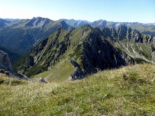
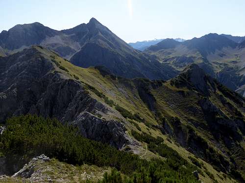
Suwaldspitzen are bordered by Älpelestal to the northeast and Loreatal / Rotlechtal to the southwest. The north – south runnig ridge, coming from Hönig / Sonnberg / Joch to the north of Vordere Suwaldspitze bends to the southeast, goes on to Hintere Suwaldspitze and bends there to the east, dropping down into a wide saddle and swinging up to Steinmanndlspitze, another unattended and lonely summit of Loreagruppe.
To summit Suwaldspitzen means hiking on unmarked trails and even off-trail, a traverse of these peaks requires rock scrambling and a short climb with grade I+ moves. The views to the south into the lonely and remote heart of Loreagruppe is fascinating, intriguing and a bit scary. Not without meaning one of the Lorea summits over there is called Unheimlicher Kopf, eerie peak ...........
Getting There
Trailhead for Suwaldspitzen is Berwang.
You reach the trailhead by car:
- From Reutte or Arlberg direction use road number 198 to Stanzach. Turn on the “Berwang-Namloser Landesstraße” (signs for Namlos, Berwang) and proceed to Berwang with the trailhead.
- Alternatively use road number 179 from Reutte to Bichlbach and turn on the “Berwang-Namloser Landesstraße” until you reach Berwang.
- From Innsbruck go on highway A 12 to the exit “Telfs”, proceed on road number 189 to Nassereith and on road number 179 to Fernpass, Lermoos and Bichlbach. Follow the signs to Berwang and Namlos to the Berwang trailhead.
- Take Highway A95 from Munich to its end and proceed on road number B2 and B23 / 187 to Lermoos. Turn on road number 179 to Bichlbach and go on like described above.


Berwang trailhead: At Berwang center follow the signs for Gröben, an upper part of Berwang village. There is a huge parking area at the Hönig ski lift valley station.
Public transportation:
Nearby railroad station is: Bichlbach. Bus number 151 goes to Berwang.
Routes Overview
Hönig, Suwaldspitzen and Steinmandlspitze Routes:
Best trailhead for Suwaldspitzen is Berwang / Höniglift parking area.
Route 1:
- Follow the road to the village of Gröben. Enter Älpelestal first on a road, then on a marked trail which leads up the valley to a trail junction. Turn right and ascend to Sonnberg col, also called Neederiger Sattel. Use the trail east of the north ridge of Vordere Suwaldspitze until it ends south of the east ridge of the mountain. Climb the peak off-trail directly over the east slope.
- Alternatively you can reach Sonnberg col via the Hönig traverse. After passing through Gröben take the righthand forest road going up the east slopes of Hönig until the road ends on the north ridge. Follow the zigzag trail up the north ridge to Hönig and traverse the ridge to Sonnberg, Joch and Sonnberg col. Go on as described above.


Route 2:
Follow the trail from the trail junction at Älpelestal to Sonnberg col until the trail starts to climb up to the col. Leave the trail to the left and ascend off-trail the northern slopes in front of you (some bushwacking required) until you reach an upper near level part of the valley. There is a scree field in front of you going up to the col between Steinmanndlspitze and Hintere Suwaldspitze. You soon will find an unmarked trail going up to this col. Turn right there and follow the rocky east ridge off-trail to Hintere Suwaldspitze (some grade I+ moves, interesting). Don´t use the visible and luring hunters trail south of the ridge to Hintere Suwaldspitze. You will get lost!
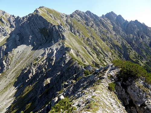

The traverse Vordere to Hintere Suwaldspitze is about 10 minutes on an unmarked track.
Hoher Schrofen can be reached in another ten minutes from Hintere Suwaldspitze.
The traverse Hintere Suwaldspitze - Steinmandlspitze uses the east ridge of the first and then the easy but off-trail west ridge of the latter; allow 1,5 hours for the traverse.


Red Tape & Accommodation
No Red Tape as far as I know
Accommodation:
No mountain huts in this area
Gear & Mountain Condition
Suwaldspitzen can be summited in late spring, summer and autumn. These summits require hiking gear and good shoes.
The traverse has some short grade I climbing moves along the east ridge of Hintere Suwaldspitze and some off-trail parts.

Weather at Berwang:
Maps
Alpenvereinskarte, scale 1 : 25000
Number 4/1, Wetterstein und Mieminger Gebirge West, edition 2016 with trails and UTM-grid

Österreichische Karte, scale 1 : 50000
Number 2221, Imst, with UTM-grid, BEV – Bundesamt für Eich- und Vermessungswesen, Wien
Österreichische Karte, scale 1 : 25000
Number 2221-Ost, Erwald, with UTM-grid, BEV – Bundesamt für Eich- und Vermessungswesen, Wien, edition 2013